
Turner, Maine facts for kids
Quick facts for kids
Turner, Maine
|
|
|---|---|

The Leavitt Institute building, now the public library
|
|

Location of Turner (in yellow) in Androscoggin County and the state of Maine
|
|

Turner, Maine
Location in the United States
|
|
| Country | United States |
| State | Maine |
| County | Androscoggin |
| Incorporated | 1786 |
| Villages | Turner Turner Center Chase Mills North Turner South Turner |
| Area | |
| • Total | 62.72 sq mi (162.44 km2) |
| • Land | 59.26 sq mi (153.48 km2) |
| • Water | 3.46 sq mi (8.96 km2) |
| Elevation | 417 ft (127 m) |
| Population
(2020)
|
|
| • Total | 5,817 |
| • Density | 98/sq mi (37.9/km2) |
| Time zone | UTC-5 (Eastern (EST)) |
| • Summer (DST) | UTC-4 (EDT) |
| ZIP codes |
04282 (Turner)
04266 (North Turner) |
| Area code(s) | 207 |
| FIPS code | 23-77800 |
| GNIS feature ID | 0582770 |
Turner is a small town located in Androscoggin County, Maine, United States. In 2020, about 5,817 people lived there. The town includes several smaller areas like Turner Center and North Turner. Turner is part of the larger Lewiston-Auburn metropolitan area.
Contents
History of Turner
Early Beginnings and Naming
Turner was first called Sylvester-Canada. This land was given on June 20, 1768. It was a reward to soldiers who fought in the 1690 Battle of Quebec. The original land grant was found to be invalid. So, a new area was chosen for them.
Reverend Charles Turner helped the soldiers get their new land. He later became the first minister of the town. The town was settled in 1772 by people like Daniel Staples and Joseph Leavitt. Many early settlers came from towns near Plymouth, Massachusetts.
After the Revolutionary War, more families moved to Turner. By 1784, there were 30 families living there. On July 7, 1786, Sylvester-Canada officially became a town. It was renamed Turner to honor Reverend Charles Turner.
Growing Industries
Turner was mainly a farming town. Farmers grew corn and apples. The town also had great water power from the Nezinscot River. This power was used to run mills.
In 1775, Samuel Blake built the first mill. It was both a sawmill (for cutting wood) and a gristmill (for grinding grain). A big flood in 1785 destroyed it, but it was rebuilt quickly. By 1886, Turner had many industries. These included:
- Sawmills and gristmills
- A box factory
- A carriage factory
- A shoe factory
- A tannery (for making leather)
- A paper pulp mill
- A cheese factory
- A fulling mill (for making cloth thicker)
- A pottery factory
Geography and Climate
Where Turner Is Located
Turner covers about 62.72 square miles (162.44 square kilometers). Most of this area is land. The Nezinscot River, Martin's Stream, and the Androscoggin River flow through Turner. The Androscoggin River forms the eastern border of the town.
Several state roads cross through Turner. These include Maine State Route 4, 117, and 219. Turner shares its borders with several other towns. These are Hartford, Buckfield, Hebron, Livermore, Minot, Auburn, Greene, and Leeds.
Turner's Weather
Turner has a humid continental climate. This means it has big changes in temperature throughout the year. Summers are usually warm to hot, and sometimes humid. Winters are cold, and can be very cold.
Population and People
How Many People Live Here?
The population of Turner has grown a lot over the years.
| Historical population | |||
|---|---|---|---|
| Census | Pop. | %± | |
| 1790 | 349 | — | |
| 1800 | 722 | 106.9% | |
| 1810 | 1,129 | 56.4% | |
| 1820 | 1,726 | 52.9% | |
| 1830 | 2,220 | 28.6% | |
| 1840 | 2,479 | 11.7% | |
| 1850 | 2,536 | 2.3% | |
| 1860 | 2,682 | 5.8% | |
| 1870 | 2,380 | −11.3% | |
| 1880 | 2,285 | −4.0% | |
| 1890 | 2,016 | −11.8% | |
| 1900 | 1,842 | −8.6% | |
| 1910 | 1,708 | −7.3% | |
| 1920 | 1,382 | −19.1% | |
| 1930 | 1,362 | −1.4% | |
| 1940 | 1,415 | 3.9% | |
| 1950 | 1,712 | 21.0% | |
| 1960 | 1,890 | 10.4% | |
| 1970 | 2,246 | 18.8% | |
| 1980 | 3,539 | 57.6% | |
| 1990 | 4,315 | 21.9% | |
| 2000 | 4,972 | 15.2% | |
| 2010 | 5,734 | 15.3% | |
| 2020 | 5,817 | 1.4% | |
| U.S. Decennial Census | |||
In 2010, there were 5,734 people living in Turner. There were 2,193 households. A household is a group of people living together. The average household had about 2.61 people.
Who Lives in Turner?
The median age in Turner in 2010 was 41.1 years old.
- About 24.3% of residents were under 18 years old.
- About 7.1% were between 18 and 24 years old.
- About 25% were between 25 and 44 years old.
- About 31.9% were between 45 and 64 years old.
- About 11.8% were 65 years or older.
The town had a nearly equal number of males and females. About 49.9% were male and 50.1% were female.
Famous People from Turner
Many interesting people have come from Turner:
- Solon Chase (from Chase's Mill) - A state legislator and founder of the Greenback Party in Maine.
- Alonzo Conant - A judge for the Auburn Municipal Court.
- Eugene Hale - A US Senator.
- James Henry Howe - A federal judge.
- Samuel Merrill - A Governor of Iowa.
- Joshua Morris - A Maine state legislator.
- Sewall A. Phillips - A Wisconsin state legislator.
- Job Prince - President of the Maine Senate.
- Mike Rowe - A racing driver.
- Alexander B. Whitman - A Wisconsin state legislator.
- Royal Emerson Whitman - An Army officer who served in several wars.
- Ray LaMontagne - A well-known singer-songwriter.
Education in Turner

Students in Turner attend Leavitt Area High School. This school serves the local community.
Images for kids
-
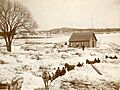
Flooding on the Androscoggin River, Turner, 1896

See also
 In Spanish: Turner (Maine) para niños
