Waterford, Maine facts for kids
Quick facts for kids
Waterford, Maine
|
|
|---|---|

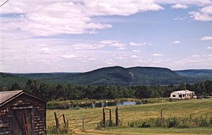
View from Blackguard Road
|
|
| Country | United States |
| State | Maine |
| County | Oxford |
| Incorporated | 1797 |
| Area | |
| • Total | 52.92 sq mi (137.06 km2) |
| • Land | 50.24 sq mi (130.12 km2) |
| • Water | 2.68 sq mi (6.94 km2) |
| Elevation | 669 ft (204 m) |
| Population
(2020)
|
|
| • Total | 1,570 |
| • Density | 31/sq mi (12.1/km2) |
| Time zone | UTC-5 (Eastern (EST)) |
| • Summer (DST) | UTC-4 (EDT) |
| ZIP Codes |
04088 (Waterford)
04267 (North Waterford) |
| Area code(s) | 207 |
| FIPS code | 23-80635 |
| GNIS feature ID | 0582794 |
Waterford is a small and pretty town located in Oxford County, Maine, in the United States. It is part of the larger Lewiston-Auburn, Maine area. In 2020, about 1,570 people lived there. Waterford is a popular place for fun outdoor activities and is known for its beautiful old buildings and lovely scenery.
Contents
History
How Waterford Got Its Start
The land where Waterford now stands was given on February 24, 1774. The Massachusetts General Court (which was like the government back then) gave it to Captain Andrew Gardner and his soldiers. This was a reward for their help in a fight against Canada in 1690.
Before this, the same land was given in 1735 and called Toddstown. But that grant was canceled when the border between Massachusetts and New Hampshire changed in 1741.
Early Settlers Arrive
The land was measured in 1774. In the spring of 1775, a man named David McWain came from Bolton, Massachusetts. He bought a piece of land for $40. He cleared the land and built a simple log cabin.
David McWain liked to be alone. He was surprised when he saw smoke from another settlement about 12 miles away! Other people soon arrived, mostly from towns in Massachusetts like Bolton and Harvard. In fact, one part of the town was even called Rowley, after the settlers' old hometown.
Becoming an Official Town
On March 2, 1797, Waterford officially became a town. More land was added from Albany in 1811. The town has many hills and mountains. It was great for raising animals and growing fruit in orchards. Farming became a very important job.
People built sawmills near streams to turn the many trees into lumber. They made things like window frames, barrel parts, and buckets. There was also a gristmill (for grinding grain), a factory that made carriages, and a tannery (for making leather).
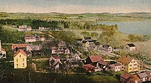
Today, a part of town called Waterford Flat is a popular place for vacations. It is home to The Lake House, an old inn built in 1797. This area has many historic buildings listed on the National Register of Historic Places.
Geography
Waterford's Location and Size
Waterford covers about 52.92 square miles (137.06 square kilometers). Most of this area, about 50.24 square miles (130.12 square kilometers), is land. The rest, about 2.68 square miles (6.94 square kilometers), is water.
Lakes and Rivers
The Crooked River flows through Waterford. The town also has several small lakes and ponds. These include Keoka Lake, McWain Pond, and Bear Pond. You can also find Mount Tire'm here.
Nearby Towns
Waterford is connected by state roads 35, 37, and 118. It shares borders with several other towns. These include Norway to the northeast, Albany and Stoneham to the northwest, and Sweden and Lovell to the southwest. To the southeast, you'll find Harrison and Bridgton.
Demographics
How Many People Live Here?
| Historical population | |||
|---|---|---|---|
| Census | Pop. | %± | |
| 1790 | 154 | — | |
| 1800 | 535 | 247.4% | |
| 1810 | 860 | 60.7% | |
| 1820 | 1,035 | 20.3% | |
| 1830 | 1,123 | 8.5% | |
| 1840 | 1,381 | 23.0% | |
| 1850 | 1,448 | 4.9% | |
| 1860 | 1,407 | −2.8% | |
| 1870 | 1,286 | −8.6% | |
| 1880 | 1,161 | −9.7% | |
| 1890 | 1,001 | −13.8% | |
| 1900 | 917 | −8.4% | |
| 1910 | 934 | 1.9% | |
| 1920 | 765 | −18.1% | |
| 1930 | 743 | −2.9% | |
| 1940 | 836 | 12.5% | |
| 1950 | 828 | −1.0% | |
| 1960 | 834 | 0.7% | |
| 1970 | 760 | −8.9% | |
| 1980 | 951 | 25.1% | |
| 1990 | 1,299 | 36.6% | |
| 2000 | 1,455 | 12.0% | |
| 2010 | 1,553 | 6.7% | |
| 2020 | 1,570 | 1.1% | |
| U.S. Decennial Census | |||
The population of Waterford has changed over many years. In 1790, only 154 people lived here. By 2020, the population had grown to 1,570 people.
A Look at the Community (2010)
In 2010, there were 1,553 people living in Waterford. Most residents were White (97.9%). The average age of people in the town was about 45.9 years old. About 20.8% of the residents were under 18 years old.
Sites of Interest
Waterford has several interesting places to visit:
- Waterford Historical Society & Museum: Learn about the town's past.
- Birch Rock Camp: A summer camp for boys.
- Camp Waziyatah: This camp was featured in the Disney Channel shows Bug Juice and Bug Juice: My Adventures at Camp.
- Camp Wigwam for Boys: A summer camp where famous writer J.D. Salinger spent time.
Notable People
Many interesting people have connections to Waterford:
- Charles Farrar Browne (also known as Artemus Ward): A famous writer.
- Mary Moody Emerson: A deep thinker known as a Transcendentalist.
- Elbridge Gerry: A person who served in the U.S. Congress.
- Cyrus Hamlin: A missionary and educator.
- Charlotte Elizabeth McKay: A nurse during the Civil War, an editor, and someone who was against women getting the right to vote.
- Sawin Millett: A representative in the Maine state government.
- Thomas Treadwell Stone: A minister who worked to end slavery.
See also
 In Spanish: Waterford (Maine) para niños
 | William L. Dawson |
 | W. E. B. Du Bois |
 | Harry Belafonte |


