Mexico, Maine facts for kids
Quick facts for kids
Mexico, Maine
|
|
|---|---|
| Country | United States |
| State | Maine |
| County | Oxford |
| Area | |
| • Total | 23.57 sq mi (61.05 km2) |
| • Land | 23.34 sq mi (60.45 km2) |
| • Water | 0.23 sq mi (0.60 km2) |
| Elevation | 1,001 ft (0 m) |
| Population
(2020)
|
|
| • Total | 2,756 |
| • Density | 118/sq mi (45.6/km2) |
| Time zone | UTC-5 (Eastern (EST)) |
| • Summer (DST) | UTC-4 (EDT) |
| ZIP code |
04257
|
| Area code(s) | 207 |
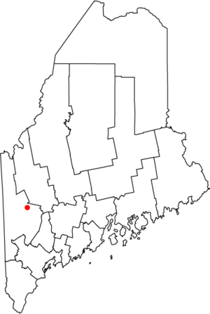
Mexico is a small town in Oxford County, Maine, in the United States. It is located near the town of Rumford. Mexico is part of the larger Lewiston-Auburn metropolitan area.
In 2020, about 2,756 people lived in Mexico. The town is known as a "mill town" because it has a history with the papermaking industry.
Contents
History of Mexico
The land where Mexico now stands was once called Holmanstown Plantation. A "plantation" was an early type of settlement. This land was given to Colonel Jonathan Holman and others in 1789.
In 1818, the remaining part of the plantation officially became the town of Mexico. The first settler here was Isaac Gleason. The town was named Mexico because people in the area supported Mexico's fight for independence from Spain, which happened between 1810 and 1821.
Mexico started as a farming community. It had many mills that used the power of streams. In 1894, a new settlement called Ridlonville was founded in the eastern part of town. It was started by George W. Ridlon, who built homes and a hotel there.

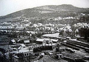
Mexico is built on several hills. These hills look over the Androscoggin River. Across the river is the town of Rumford, which has a large paper mill. The Swift River also flows into the Androscoggin River in Mexico.
The main part of Mexico is located where these two rivers meet. Because it's near the rivers, Mexico has experienced floods many times. Some big floods happened in 1936, 1953, and 1987.
Geography of Mexico
Mexico covers a total area of about 23.57 square miles (61.05 square kilometers). Most of this area is land, about 23.34 square miles (60.45 square kilometers). The rest is water.
The town is drained by the Swift River and the Androscoggin River. The Androscoggin River forms the southern border of Mexico, separating it from Rumford.
Population Changes
| Historical population | |||
|---|---|---|---|
| Census | Pop. | %± | |
| 1820 | 148 | — | |
| 1830 | 343 | 131.8% | |
| 1840 | 447 | 30.3% | |
| 1850 | 482 | 7.8% | |
| 1860 | 671 | 39.2% | |
| 1870 | 458 | −31.7% | |
| 1880 | 403 | −12.0% | |
| 1890 | 355 | −11.9% | |
| 1900 | 816 | 129.9% | |
| 1910 | 2,065 | 153.1% | |
| 1920 | 3,242 | 57.0% | |
| 1930 | 4,767 | 47.0% | |
| 1940 | 4,431 | −7.0% | |
| 1950 | 4,762 | 7.5% | |
| 1960 | 5,043 | 5.9% | |
| 1970 | 4,309 | −14.6% | |
| 1980 | 3,698 | −14.2% | |
| 1990 | 3,344 | −9.6% | |
| 2000 | 2,959 | −11.5% | |
| 2010 | 2,681 | −9.4% | |
| 2020 | 2,756 | 2.8% | |
| U.S. Decennial Census | |||
The population of Mexico has changed over the years. In 2010, there were 2,681 people living in the town. By 2020, the population had grown slightly to 2,756 people.
Places to Visit
- Mexico Historical Society & Museum
Learning Opportunities
Mexico has access to higher education through University College at Rumford/Mexico. This college is part of the University of Maine System. It offers many ways to learn, including:
- Classes in traditional classrooms
- Interactive television (ITV)
- Video conferencing
- Online courses
- Blended classes that use different methods
Students can take a few courses for fun or complete full programs. The college also helps students with things like library services, advice for their studies, and finding jobs.
Famous People from Mexico
Some well-known people have come from Mexico, Maine:
- Chummy Broomhall – a cross-country skier
- Ed McMahon – a famous entertainment personality
- Charles W. Walton – a US congressman
Climate in Mexico
Mexico experiences a humid continental climate. This means it has big differences in temperature throughout the year. Summers are warm to hot and can be humid. Winters are cold, sometimes very cold.
| Climate data for Mexico, Maine | |||||||||||||
|---|---|---|---|---|---|---|---|---|---|---|---|---|---|
| Month | Jan | Feb | Mar | Apr | May | Jun | Jul | Aug | Sep | Oct | Nov | Dec | Year |
| Mean daily maximum °F (°C) | 27 (−3) |
31 (−1) |
39 (4) |
52 (11) |
66 (19) |
75 (24) |
79 (26) |
77 (25) |
69 (21) |
57 (14) |
43 (6) |
31 (−1) |
54 (12) |
| Mean daily minimum °F (°C) | 7 (−14) |
8 (−13) |
19 (−7) |
31 (−1) |
41 (5) |
51 (11) |
56 (13) |
54 (12) |
46 (8) |
36 (2) |
28 (−2) |
14 (−10) |
33 (1) |
| Average precipitation inches (cm) | 3 (7.6) |
2.6 (6.6) |
3.4 (8.6) |
3.8 (9.7) |
3.8 (9.7) |
4.3 (11) |
3.8 (9.7) |
4 (10) |
3.5 (8.9) |
4.2 (11) |
4.7 (12) |
3.7 (9.4) |
45 (110) |
| Source: Weatherbase | |||||||||||||
See also
 In Spanish: México (Maine) para niños
 | Georgia Louise Harris Brown |
 | Julian Abele |
 | Norma Merrick Sklarek |
 | William Sidney Pittman |


