
Bethel, Maine facts for kids
Quick facts for kids
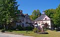
Bethel, Maine
|
|
|---|---|

Bethel Common
|
|
| Motto(s):
"Maine's Most Beautiful Mountain Village"
|
|

Bethel, Maine
Location in Maine

Bethel, Maine
Location in the United States
|
|
| Country | United States |
| State | Maine |
| County | Oxford |
| Incorporated | 1796 |
| Villages | Bethel East Bethel Mayville West Bethel |
| Area | |
| • Total | 65.91 sq mi (170.71 km2) |
| • Land | 64.60 sq mi (167.31 km2) |
| • Water | 1.31 sq mi (3.39 km2) |
| Elevation | 679 ft (207 m) |
| Population
(2020)
|
|
| • Total | 2,504 |
| • Density | 39/sq mi (15.0/km2) |
| Time zone | UTC-5 (Eastern (EST)) |
| • Summer (DST) | UTC-4 (EDT) |
| ZIP Codes | |
| Area code(s) | 207 |
| FIPS code | 23-04825 |
| GNIS feature ID | 0582352 |


Bethel is a charming town located in Oxford County, Maine, United States. In 2020, about 2,504 people lived here. The town includes the smaller villages of Bethel and West Bethel. Bethel is also home to Gould Academy, a private school that helps students get ready for college. It is also very close to the popular Sunday River ski resort.
Contents
A Glimpse into Bethel's Past
Early Days and First Settlers
Long ago, an Abenaki Native American village stood on the north side of the Androscoggin River. This village was no longer there when English settlers arrived. In 1769, the land was given to Josiah Richardson and others from Sudbury, Massachusetts. This was a reward for their service in a battle in Quebec in 1690.
The first English settlers arrived in 1774. Nathaniel Segar from Newton, Massachusetts, began clearing the land. However, the Revolutionary War made it hard for many people to move there.
Growing Pains and New Beginnings
Only 10 families lived in the area when it was attacked on August 3, 1781. This was the last Native American attack in Maine. Two people, Benjamin Clark and Nathaniel Segar, were taken to Quebec. They were held there until the war ended. After the war, the community grew quickly. On June 10, 1796, the area officially became a town called Bethel. The name "Bethel" comes from the Bible and means "House of God."
How Bethel Grew and Changed
In 1802, a new trade road (now Route 26) was finished. It connected Portland to Errol, New Hampshire, and passed right through Bethel. This road helped the town grow even more. More settlers and businesses arrived. Farmers planted crops like hay and potatoes in the rich fields.
In winter, many farmers worked in logging. They cut down trees, and the wood was processed at sawmills powered by water. Other businesses made things like flour, leather, furniture, boots, shoes, and carriages. A large hotel called the Bethel House was built in 1833.
The Age of Trains and Tourism
On March 10, 1851, the Atlantic and St. Lawrence Railroad opened in Bethel. This brought both goods and summer tourists. People from cities wanted to escape the noise and heat. Between the Civil War and World War I, Bethel became a popular summer vacation spot. Many hotels were built, including The Prospect Hotel, which was very large.
Guests could take tours through the beautiful White Mountains and Maine. A famous clinic for people with stress also brought many wealthy visitors. Music festivals were held in Bethel between 1897 and 1926.
When cars became popular, tourists could travel anywhere. They were no longer limited by train routes. Because of this, many big hotels near the train tracks lost their guests and were eventually torn down. The Prospect Hotel was mostly destroyed by fire in 1911. Even though travel has changed, Bethel is still a great place to visit for its nature, history, and fun activities.
Bethel's Role in Organizational Development
Since 1947, Bethel has been important for a field called "organizational development." This field helps groups and companies work better together. A psychologist named Kurt Lewin and his team did important research here. They developed ways to help people understand themselves and work well in groups. This helped organizations become more efficient.
The National Training Laboratories (NTL) was created by Lewin to lead this work. Many training sessions happened in the summer at Gould Academy. People from all over the world came to learn. NTL became a big part of Bethel's economy, especially as the traditional wood industries slowed down. NTL moved its main office in 2008, but it still has a small summer program in Bethel.
Exploring Bethel's Geography
Bethel is located on the western side of the Oxford Hills. It is also on the southern edge of the rugged Mahoosuc Range. Nearby Locke and Barker Mountains are part of the Mahoosuc Range. This range is a smaller part of the White Mountains, which are part of the larger Appalachian Mountains.
The Androscoggin River flows through Bethel and the surrounding area. Smaller rivers like the Alder, Pleasant, and Sunday Rivers flow into it. Part of Songo Pond is within Bethel's borders. Just south of Bethel, you can find South Pond, North Pond, and Bryant Ponds. The town covers about 65.91 square miles (170.71 square kilometers). Most of this is land, with a small amount of water.
Population of Bethel
| Historical population | |||
|---|---|---|---|
| Census | Pop. | %± | |
| 1800 | 616 | — | |
| 1810 | 975 | 58.3% | |
| 1820 | 1,267 | 29.9% | |
| 1830 | 1,620 | 27.9% | |
| 1840 | 1,994 | 23.1% | |
| 1850 | 2,253 | 13.0% | |
| 1860 | 2,523 | 12.0% | |
| 1870 | 2,286 | −9.4% | |
| 1880 | 2,077 | −9.1% | |
| 1890 | 2,209 | 6.4% | |
| 1900 | 1,835 | −16.9% | |
| 1910 | 1,930 | 5.2% | |
| 1920 | 1,792 | −7.2% | |
| 1930 | 2,025 | 13.0% | |
| 1940 | 2,034 | 0.4% | |
| 1950 | 2,367 | 16.4% | |
| 1960 | 2,408 | 1.7% | |
| 1970 | 2,220 | −7.8% | |
| 1980 | 2,340 | 5.4% | |
| 1990 | 2,329 | −0.5% | |
| 2000 | 2,411 | 3.5% | |
| 2010 | 2,607 | 8.1% | |
| 2020 | 2,504 | −4.0% | |
| U.S. Decennial Census | |||
In 2010, there were 2,607 people living in Bethel. Most residents were White (97.2%). About 23.3% of the people were under 18 years old. The average age in town was about 42.9 years.
Fun Things to See and Do
Places to Visit
- Museums of the Bethel Historical Society: Learn about the town's past.
- Middle Intervale Meeting House and Common: A historic meeting house.
- Bethel Inn Resort: A place to stay and enjoy activities.
- Sunday River Ski Resort: Great for skiing and snowboarding.
- Maine Mineral and Gem Museum: Discover amazing rocks and gems.
Education in Bethel
Public Schools
Bethel is part of Maine School Administrative District 44 (MSAD 44).
- Crescent Park Elementary School
- Telstar Regional Middle/High School
Private School
- Gould Academy: A private school that prepares students for college.
Famous People from Bethel
Many interesting people have connections to Bethel:
- Henry J. Bean: A judge and state representative in Oregon.
- Matt Bevin (born 1967): A former student at Gould Academy and a Governor of Kentucky.
- Richard Blanco: A poet who read at a U.S. presidential inauguration in 2013.
- Simon Dumont: A professional freeskier.
- La Fayette Grover: A former Governor of Oregon and a member of the U.S. House and Senate.
- Moses Mason: A doctor and congressman.
- Edward Sylvester Morse (1838–1925): A former student at Gould Academy and a museum director.
- Patty Bartlett Sessions: A midwife.
Images for kids
-
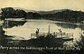
Ferry across the Androscoggin River at West Bethel in 1909
-
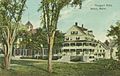
The Prospect Hotel, largest in Bethel, as it appeared in 1909
-
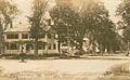
Church Street in c. 1912
-
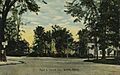
Main and Church streets in 1913
-
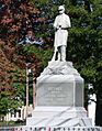
Memorial to American Civil War veterans
-
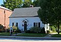
Bethel Public Library
-
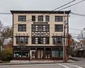
Cole Block Bethel Maine
-
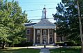
Gould Academy
-
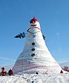
Bethel's Olympia Snow Woman (122 ft, 2008), named for Senator Olympia Snowe
-
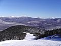
Sunday River Ski Resort near Bethel
-
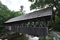
Sunday River Covered Bridge near Bethel
-
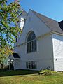
Methodist Church
-
Victoria Inn


See also
 In Spanish: Bethel (Maine) para niños
