
Peru, Maine facts for kids
Quick facts for kids
Peru, Maine
|
|
|---|---|

Bird's-eye view
|
|

Peru, Maine
Location in Maine

Peru, Maine
Location in the United States
|
|
| Country | United States |
| State | Maine |
| County | Oxford |
| Incorporated | 1821 |
| Area | |
| • Total | 47.60 sq mi (123.28 km2) |
| • Land | 46.68 sq mi (120.90 km2) |
| • Water | 0.92 sq mi (2.38 km2) |
| Elevation | 807 ft (246 m) |
| Population
(2020)
|
|
| • Total | 1,488 |
| • Density | 32/sq mi (12.3/km2) |
| Time zone | UTC-5 (Eastern (EST)) |
| • Summer (DST) | UTC-4 (EDT) |
| ZIP code |
04290
|
| Area code(s) | 207 |
| FIPS code | 23-58270 |
| GNIS feature ID | 0582673 |
Peru is a small town located in Oxford County, Maine, in the United States. It's part of the wider Lewiston-Auburn area. In 2020, about 1,488 people lived here.
Contents
A Look at Peru's Past
Peru, Maine, has an interesting history that began long ago. It was first given to people from Falmouth, Maine, by the Massachusetts General Court. The very first person to settle there was Merrill Knight in 1793.
How Peru Became a Town
The area was first organized in 1812 as "Plantation Number 1." It was also known as Thompsontown. Then, on February 5, 1821, it officially became the 240th town in Maine. The town was named Peru to show support for the country of Peru in South America. That country had just declared its independence from Spain on July 28, 1821.
Early Life and Work in Peru
In the early days, farming was a very important job in Peru. The land had dark, stone-free soil, which was perfect for growing crops. Hay was the main crop, and many people also raised sheep. Besides farming, there were five sawmills in town. These mills made different types of lumber and even special wooden bowls. By 1870, the town's population was 931 people.
Peru's School System Changes
For a long time, Peru had its own public school system. But in 2006, it joined Maine School Administrative District 21. Later, in 2009, it moved to RSU (Regional School Unit) #10. Most recently, in 2017, Peru joined RSU #56, which also includes the towns of Canton, Carthage, and Dixfield.
Peru's Location and Landscape
Peru is a town with a good amount of land and some water. The United States Census Bureau says the town covers about 47.60 square miles (123.28 square kilometers). Most of this is land, about 46.68 square miles (120.90 square kilometers). The rest, about 0.92 square miles (2.38 square kilometers), is water.
Rivers and Ponds in Peru
The Androscoggin River helps drain water from Peru. There's also a beautiful body of water called Worthley Pond. This pond is about two miles long and half a mile wide. You can find it in the southern part of the town.
Mountains Near Peru
Peru is also home to some impressive mountains. The tallest is Mt. Zircon, which stands at 2,221 feet (677 meters) tall. Other notable mountains include Black Mountain, at 2,129 feet (649 meters), and Speckled Mountain, at 2,116 feet (645 meters).
Who Lives in Peru?
The population of Peru has changed over the years. Here's a quick look at how many people have lived in the town during different census years:
| Historical population | |||
|---|---|---|---|
| Census | Pop. | %± | |
| 1820 | 343 | — | |
| 1830 | 666 | 94.2% | |
| 1840 | 1,002 | 50.5% | |
| 1850 | 1,109 | 10.7% | |
| 1860 | 1,121 | 1.1% | |
| 1870 | 931 | −16.9% | |
| 1880 | 825 | −11.4% | |
| 1890 | 692 | −16.1% | |
| 1900 | 773 | 11.7% | |
| 1910 | 746 | −3.5% | |
| 1920 | 738 | −1.1% | |
| 1930 | 826 | 11.9% | |
| 1940 | 965 | 16.8% | |
| 1950 | 1,080 | 11.9% | |
| 1960 | 1,229 | 13.8% | |
| 1970 | 1,345 | 9.4% | |
| 1980 | 1,564 | 16.3% | |
| 1990 | 1,541 | −1.5% | |
| 2000 | 1,515 | −1.7% | |
| 2010 | 1,541 | 1.7% | |
| 2020 | 1,488 | −3.4% | |
| U.S. Decennial Census | |||
Peru's Population in 2020
According to the census taken in 2020, there were 1,488 people living in Peru. These people made up 697 households, and 429 of those were families. The average age of people in Peru was 49.4 years old.
Most of the people in Peru identified as White (94.4%). A smaller number identified as Native American (0.5%), Asian (0.3%), or from other races (0.5%). About 4.0% of the population identified as being from two or more races. People who identified as Hispanic or Latino made up 0.9% of the population.
In terms of households, about 24.3% had children under 18 living with them. Many households (51.1%) were married couples living together. There were also households led by a female without a husband (19.3%) or by a male without a wife (17.7%). About 33.7% of households were not families.
Peru's Population in 2010
The census from 2010 showed that 1,541 people lived in Peru. There were 629 households, with 446 of them being families. The town had about 909 housing units.
The racial makeup was mostly White (97.6%). Other groups included Native American (0.6%), Asian (0.3%), and people from other races (0.3%). About 1.1% of people identified as two or more races. Hispanic or Latino people made up 0.3% of the population.
In 2010, 28.1% of households had children under 18. Most households (57.2%) were married couples. The average age in Peru was 47 years. About 18.9% of residents were under 18, and 16.1% were 65 or older. The population was almost evenly split between males (49.5%) and females (50.5%).
Famous People from Peru
Even small towns can have famous people! Here are a couple of notable individuals who came from Peru, Maine:
- Clinton Briggs Ripley - A well-known architect who designed buildings.
- Samuel Thurston - He was the very first person to represent the Oregon Territory in Congress.
Images for kids
-
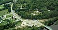
Bird's-eye view of Peru, Maine
See also
 In Spanish: Peru (Maine) para niños
