
South Paris, Maine facts for kids
Quick facts for kids
South Paris
|
|
|---|---|

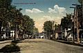
Market Square in 1907
|
|

South Paris, Maine
Location in Maine
|
|
| Country | United States |
| State | Maine |
| County | Oxford |
| Area | |
| • Total | 3.95 sq mi (10.23 km2) |
| • Land | 3.88 sq mi (10.04 km2) |
| • Water | 0.07 sq mi (0.19 km2) |
| Elevation | 387 ft (118 m) |
| Population
(2020)
|
|
| • Total | 2,183 |
| • Density | 563.21/sq mi (217.46/km2) |
| Demonym(s) | South Parisian |
| Time zone | UTC-5 (Eastern (EST)) |
| • Summer (DST) | UTC-4 (EDT) |
| ZIP code |
04281
|
| Area code(s) | 207 |
| FIPS code | 23-71780 |
| GNIS feature ID | 0575877 |
South Paris is a small community in Maine, United States. It's part of the larger town of Paris in Oxford County. In 2020, about 2,183 people lived here. Even though "South Paris" officially means a specific area, many people use the name for the whole town of Paris, except for a historic part called Paris Hill.
Contents
History of South Paris
Early Growth and Mills
During the 1800s, the Little Androscoggin River was very important for South Paris. Its water power helped run many mills in the area. Because of these mills, the village of South Paris began to grow.
Railroad and Development
On June 8, 1850, the Atlantic and St. Lawrence Railroad opened. This new railroad helped the small mill town grow even more. In the 1890s, the Oxford County Courthouse moved from Paris Hill to be closer to the Grand Trunk Railway station.
Changes Over Time
Much of the manufacturing and industry in South Paris slowed down during the Great Depression. However, South Paris is still the main business area of Paris. It also has many buildings with beautiful Victorian designs. Oxford Hills Comprehensive High School, the local high school for the region, was started in South Paris in 1961.
Famous People from South Paris
The actress Reta Shaw was born in South Paris in 1912.
Geography of South Paris
South Paris is located at coordinates 44°13′18″N 70°30′53″W / 44.22167°N 70.51472°W. This means it's in the northern part of the world, and west of the prime meridian.
Land and Water
The community covers about 4.0 square miles (10.2 square kilometers). Most of this area, about 3.9 square miles (10.0 square kilometers), is land. A small part, about 0.1 square mile (0.2 square kilometers), is water. The Little Androscoggin River flows through South Paris.
Roads and Parks
Several main roads pass through South Paris. These include Maine State Route 26, 117, 118, and 119.
The town also has a small park called Moore Park. It has a new, fenced-in playground for children. Moore Park features a monument in the center and a gazebo for public events.
Population and People
| Historical population | |||
|---|---|---|---|
| Census | Pop. | %± | |
| 2020 | 2,183 | — | |
| U.S. Decennial Census | |||

In 2008, there were 2,237 people living in South Paris. Most people living here are White. A small number of people are African American, Native American, or Asian. Some people are also from two or more races. A small percentage of the population is Hispanic or Latino.

The average age of people in South Paris in 2008 was 39 years old. About 20.4% of the population was under 18 years old.
Notable People
- Reta Shaw, an actress
- James Deering, a business leader and collector
- Hannibal Hamlin, who was the first vice president for Abraham Lincoln
- Cora S. Briggs, an organist and composer
Places to Visit
- Celebration Barn Theater
- Paris Cape Historical Society
Images for kids
-
Pleasant Street in 1913
-
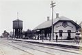
Railroad station around 1915
-

Moore Park in 1909


See also
 In Spanish: South Paris (Maine) para niños
