Byron, Maine facts for kids
Quick facts for kids
Byron, Maine
|
|
|---|---|

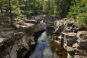
Coos Canyon, in the center of Byron
|
|
| Country | United States |
| State | Maine |
| County | Oxford |
| Incorporated | 1833 |
| Area | |
| • Total | 52.56 sq mi (136.13 km2) |
| • Land | 51.81 sq mi (134.19 km2) |
| • Water | 0.75 sq mi (1.94 km2) |
| Elevation | 948 ft (289 m) |
| Population
(2020)
|
|
| • Total | 103 |
| • Density | 2/sq mi (0.8/km2) |
| Time zone | UTC-5 (Eastern (EST)) |
| • Summer (DST) | UTC-4 (EDT) |
| ZIP code |
04275
|
| Area code(s) | 207 |
| FIPS code | 23-09550 |
| GNIS feature ID | 0582381 |
Byron is a small town located in Oxford County, Maine, United States. In 2020, about 103 people lived there. Byron is famous for Coos Canyon on the Swift River. The village of Houghton is also part of Byron.
Contents
History of Byron
Byron was first settled as "Township No. 8." It officially became a town on January 24, 1833. The town was named after the famous English poet, Lord Byron.
Early Life in Byron
Byron was once nicknamed "Hop City." The main jobs here were farming. People grew crops like wheat, corn, potatoes, and oats. In winter, logging was a big activity, and there were two sawmills working.
In 1896, the Rumford Falls & Rangeley Lakes Railroad was finished. This train line helped carry goods, tourists, and visitors from Rumford through Byron and Houghton, all the way to Mooselookmeguntic Lake.
Coos Canyon and the Swift River
The Swift River is a very popular spot. Many people come here to look for gold or to swim at Coos Canyon. Coos Canyon is a gorge that is about 32 feet (10 meters) high. The water in the gorge can sometimes be more than 20 feet (6 meters) deep!
Just a bit downriver from the gorge, you'll find a small local beach called Toby's Beach. There's also a 20-foot (6-meter) ledge that brave jumpers enjoy during the summer. You can find a camping area across from Coos Canyon, off state route 17.
Byron is also the home of Anthony Boucher, a successful college cross country runner.
Geography of Byron
Byron covers an area of about 52.56 square miles (136.13 square kilometers). Most of this area is land, with a small part being water. The town is located in the Western Maine Mountains. The Swift River flows through Byron, draining its lands.
Neighboring Areas
State route 17 crosses through the town. Byron shares its borders with:
Population Facts
Byron's population has changed over the years. Here's how many people have lived in Byron during different census years:
| Historical population | |||
|---|---|---|---|
| Census | Pop. | %± | |
| 1840 | 219 | — | |
| 1850 | 296 | 35.2% | |
| 1860 | 323 | 9.1% | |
| 1870 | 242 | −25.1% | |
| 1880 | 191 | −21.1% | |
| 1890 | 180 | −5.8% | |
| 1900 | 204 | 13.3% | |
| 1910 | 187 | −8.3% | |
| 1920 | 217 | 16.0% | |
| 1930 | 96 | −55.8% | |
| 1940 | 125 | 30.2% | |
| 1950 | 96 | −23.2% | |
| 1960 | 108 | 12.5% | |
| 1970 | 132 | 22.2% | |
| 1980 | 114 | −13.6% | |
| 1990 | 111 | −2.6% | |
| 2000 | 121 | 9.0% | |
| 2010 | 145 | 19.8% | |
| 2020 | 103 | −29.0% | |
| U.S. Decennial Census | |||
In 2010, there were 145 people living in Byron. There were 58 households, and 35 of these were families. The average age of people in Byron was about 49 years old.
Cool Places to Visit
Byron and its nearby areas offer several interesting spots:
- Coos Canyon
- Height of Land
- Tumbledown Mountain
- Angel Falls
- Ellis Pond
See also
 In Spanish: Byron (Maine) para niños
 | George Robert Carruthers |
 | Patricia Bath |
 | Jan Ernst Matzeliger |
 | Alexander Miles |


