Tumbledown Mountain facts for kids
Quick facts for kids Tumbledown Mountain |
|
|---|---|

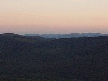
Tumbledown Mountain at sunset
|
|
| Highest point | |
| Elevation | 3,054 ft (931 m) |
| Prominence | 1,400 ft (430 m) |
| Geography | |
| Climbing | |
| Easiest route | Hiking, class 1 |
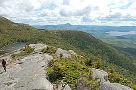
Tumbledown Mountain is a cool mountain located in Franklin County, Maine. It's a super popular place for hiking in western Maine. You can find the start of the trails on Byron Road, which is north of Weld. A special feature of Tumbledown Mountain is a beautiful pond right below the very top. People often call this pond Crater Lake or Tumbledown Pond. The mountain is also close to Coos Canyon, which is a lovely mountain stream. Tumbledown Mountain has different trails, so there's a path for every kind of hiker!
Contents
Exploring Tumbledown Mountain
Tumbledown Mountain is known for its amazing views and the pretty pond near its summit. Hikers of all skill levels can find a trail that suits them. Some paths are easier and lead straight to the pond, while others are more challenging and take you right to the top.
Easier Paths to the Top
The easiest way to reach the Tumbledown pond is by taking either the Brook Trail or the Parker Ridge Trail. Once you get to the pond, you can then follow the Tumbledown Ridge Trail. This path is pretty clear and goes across the mountaintop, connecting the East Peak to the West Peak. It also links up with the Loop Trail, but be careful, the Loop Trail goes down very steeply. If you're not a super strong hiker, it's best to avoid going down the Loop Trail.
The Brook Trail
The Brook Trail starts about 4.5 miles down Byron Road. It's one of the most popular ways to hike up Tumbledown Mountain. There's a big parking area right across from the start of the trail, and even a restroom for hikers. The trail first follows an old logging road. Then, it climbs steeply up the mountain to Tumbledown Pond. This trail is about 2.5 miles long. It usually takes about 2 hours to hike at a good speed.
The Parker Ridge Trail
The Parker Ridge Trail is the oldest path to the pond. It slowly goes up through the woods. Then, it leads you up a steep, rocky ridge before going down to Tumbledown Pond. In the past, hikers had to use a private road to get to this trail. But now, you can get to the Parker Ridge Trail directly from the Brook Trail parking lot. It's about a one-mile walk from the parking lot to the start of the Parker Ridge Trail. From here, you can also find the trail that goes up Little Jackson Mountain. The total distance to the pond, including the walk to the trailhead, is about 3.2 miles.
Exciting Challenges for Hikers
If you're looking for a more adventurous hike, Tumbledown Mountain has some exciting options. These trails are steeper and require more effort, but they offer incredible views!
The Loop Trail
The Loop Trail starts about 5.8 miles down Byron Road, which is about 1.5 miles past the Brook Trail. The start of this trail is easy to find, and there's a good parking area. This path is one of the most direct ways to reach the summit. It climbs very steeply up the side of the mountain. Eventually, it meets the Tumbledown Ridge Trail, which takes you to the mountain's peaks. The Loop Trail is 2 rugged miles long. About one mile in, you'll see amazing views of the Tumbledown cliffs.
From there, the trail goes up a very steep gully. You'll need to do a lot of climbing over big rocks. Near the end, the trail actually goes through a narrow crack between several boulders. This tight, chimney-like passage is often called "Fat Man's Misery" in guidebooks. There are some iron rungs to help you climb. You might even need to take off your backpack to fit through! Having a friend with you can be really helpful here. If you don't like tight spaces or are afraid of heights, this trail might not be for you. Going down this trail is very tough and can be a bit risky. It's usually better to hike up the Loop Trail and then go down to the pond using the Tumbledown Ridge Trail. From the pond, you can hike back to Byron Road using the Brook Trail.
The Tumbledown Chimney Trail
The Tumbledown Chimney Trail is not maintained anymore and should be avoided. It branches off the Loop Trail about one mile in. This path goes through a very rough area with many large boulders. After that, the trail climbs a very steep, smooth rock slope. Eventually, it reaches the Tumbledown Chimney, which is about 15 feet high and very steep. You need to use a rope to pull yourself up to the top. Even though some older guidebooks mention this trail, it's not looked after anymore. Park rangers regularly patrol Tumbledown Mountain. Hikers should know that climbing this trail is quite dangerous because it's so steep. Rocks can fall here often. Getting hurt on this trail could leave a hiker in serious trouble.
In 2009, a new rope was put in at the top of the Chimney Trail. As of December 2009, it was a purple rope tied to one of the iron rungs at the top. However, the trail itself is still not maintained and can be hard to follow.
 | Delilah Pierce |
 | Gordon Parks |
 | Augusta Savage |
 | Charles Ethan Porter |


