
Rangeley, Maine facts for kids
Quick facts for kids
Rangeley, Maine
|
|
|---|---|

View from Bald Mountain
|
|
| Motto(s):
"Maine's Four Season Playground"
|
|

Rangeley, Maine
Location in Maine

Rangeley, Maine
Location in the United States
|
|
| Country | United States |
| State | Maine |
| County | Franklin |
| Incorporated | 1855 |
| Villages | Rangeley Bald Mountain Mooselookmeguntic Mountainview Oquossoc South Rangeley |
| Area | |
| • Total | 55.62 sq mi (144.06 km2) |
| • Land | 41.48 sq mi (107.43 km2) |
| • Water | 14.14 sq mi (36.62 km2) |
| Elevation | 1,614 ft (492 m) |
| Population
(2020)
|
|
| • Total | 1,222 |
| • Density | 30/sq mi (11.4/km2) |
| Time zone | UTC−5 (Eastern (EST)) |
| • Summer (DST) | UTC4 (EDT) |
| ZIP Codes |
04970 (Rangeley)
04964 (Oquosooc) |
| Area code(s) | 207 |
| FIPS code | 23-61840 |
| GNIS feature ID | 0582690 |
Rangeley is a small town in Franklin County, Maine, United States. In 2020, about 1,222 people lived here. Rangeley is known as the heart of the Rangeley Lakes Region, a popular vacation spot. The town includes the villages of Rangeley and Oquossoc, along with other communities like Mooselookmeguntic, Bald Mountain, Mountainview, and South Rangeley.
Contents
History of Rangeley
Rangeley is named after Squire James Rangeley, an Englishman. In 1825, he came to this area. He wanted to create a large estate, like those in England, with a landlord and tenants. He also gave a lot of land to settlers.
Squire Rangeley built a sawmill and a gristmill (for grinding grain). He also built a big two-story house. To connect his property to the outside world, he built a ten-mile (16 km) road. He lived in Rangeley for 15 years. Then, he sold his property and moved to Portland.
Early Industries and Growth
In the early days, farms in Rangeley grew crops like hay, wheat, oats, barley, and potatoes. Cattle also grazed on the hills. Logging became a very important industry. Logs were floated across the Rangeley lakes using steamboats. Then, they were guided down rivers in what were called log drives.
On March 29, 1855, Rangeley officially became a town. By 1870, 313 people lived there. In 1886, the town had twenty homes, two hotels, two stores, and a post office. Local businesses included a carriage shop, two blacksmith shops, a boat builder's shop, a sawmill, and a shoe shop.
The Railroad and Tourism
The Phillips and Rangeley Railroad opened in 1891. It was a narrow-gauge railway that later became part of the Sandy River and Rangeley Lakes Railroad in 1908. This railroad helped ship timber and other goods to markets. It also brought many tourists from big cities like Boston, Hartford, New York City, and Philadelphia.
Because of the railroad, the Rangeley area grew into a popular seasonal resort in the 1900s. People built camps, cabins, summer homes, inns, and hotels. The cool mountain weather and great sport fishing made it a very desirable vacation spot. Some local people became fishing guides. Even President Herbert Hoover came here to fish!
Over time, the big hotels became less popular. This happened when the railroad stopped running and more people started using cars. Vacationers began building their own private camps. For example, The Rangeley Lake House was torn down in 1958. However, smaller motels and camp rentals have taken their place. Rangeley is still a very popular resort today.
Geography and Location
Rangeley is located in the Western Maine Mountains. It sits on the eastern shores of Rangeley Lake. The town has a total area of about 55.62 square miles (144.06 km2). About 41.48 square miles (107.43 km2) is land, and 14.14 square miles (36.62 km2) is water.
The town is located between the starting points of both the Androscoggin River and Kennebec River. Just south of Rangeley, on Route 4, you can find Smalls Falls. This is a beautiful waterfall and a popular place for visitors. A sign in town even says that Rangeley is halfway between the Equator and the North Pole!
Climate and Weather
Rangeley has a climate with big temperature changes throughout the year. Summers are warm and often humid. Winters are cold, sometimes very cold. This type of climate is called a humid continental climate.
Like other parts of New England, Rangeley gets a lot of snow. Because winter temperatures are so cold, the snow often stays on the ground for several months. Summer temperatures are cooler than in other nearby towns because Rangeley is higher up.
Rangeley has seen some extreme temperatures. The hottest recorded temperature since 1969 was 94°F (34°C) on September 10, 2002. The coldest was -45°F (-43°C) on January 20, 1994. It's rare for the warmest temperature in over 50 years to happen in early fall.
Temperatures can change a lot between day and night. Even so, Rangeley can get very cold during the day sometimes. The coldest daytime high ever recorded was -18°F (-28°C) on December 26, 1980. Warm summer nights are rare. The warmest low temperature recorded was 70°F (21°C) on July 14, 1987, and July 12, 2020. The most snow ever measured on the ground was 44 inches (112 cm) on March 8, 1982, and March 31, 2001.
| Climate data for Rangeley, Maine, 1991–2020 normals, extremes 1969–present: 1530ft (466m) | |||||||||||||
|---|---|---|---|---|---|---|---|---|---|---|---|---|---|
| Month | Jan | Feb | Mar | Apr | May | Jun | Jul | Aug | Sep | Oct | Nov | Dec | Year |
| Record high °F (°C) | 56 (13) |
62 (17) |
77 (25) |
85 (29) |
92 (33) |
93 (34) |
93 (34) |
93 (34) |
94 (34) |
82 (28) |
72 (22) |
60 (16) |
94 (34) |
| Mean maximum °F (°C) | 44.3 (6.8) |
47.0 (8.3) |
56.2 (13.4) |
70.1 (21.2) |
81.6 (27.6) |
86.2 (30.1) |
87.1 (30.6) |
85.4 (29.7) |
82.0 (27.8) |
72.5 (22.5) |
60.7 (15.9) |
48.3 (9.1) |
89.2 (31.8) |
| Mean daily maximum °F (°C) | 23.0 (−5.0) |
26.6 (−3.0) |
35.7 (2.1) |
48.2 (9.0) |
62.5 (16.9) |
71.6 (22.0) |
76.4 (24.7) |
75.2 (24.0) |
67.9 (19.9) |
53.7 (12.1) |
40.4 (4.7) |
29.0 (−1.7) |
50.9 (10.5) |
| Daily mean °F (°C) | 11.7 (−11.3) |
13.2 (−10.4) |
22.6 (−5.2) |
36.4 (2.4) |
49.7 (9.8) |
59.6 (15.3) |
64.6 (18.1) |
63.0 (17.2) |
55.8 (13.2) |
43.4 (6.3) |
31.8 (−0.1) |
19.9 (−6.7) |
39.3 (4.1) |
| Mean daily minimum °F (°C) | 0.4 (−17.6) |
−0.3 (−17.9) |
9.4 (−12.6) |
24.5 (−4.2) |
37.0 (2.8) |
47.5 (8.6) |
52.7 (11.5) |
50.8 (10.4) |
43.7 (6.5) |
33.2 (0.7) |
23.3 (−4.8) |
10.7 (−11.8) |
27.7 (−2.4) |
| Mean minimum °F (°C) | −24.1 (−31.2) |
−22.4 (−30.2) |
−15.9 (−26.6) |
9.0 (−12.8) |
25.7 (−3.5) |
35.1 (1.7) |
42.9 (6.1) |
40.4 (4.7) |
30.5 (−0.8) |
21.5 (−5.8) |
6.8 (−14.0) |
−11.6 (−24.2) |
−27.0 (−32.8) |
| Record low °F (°C) | −45 (−43) |
−38 (−39) |
−36 (−38) |
−9 (−23) |
18 (−8) |
28 (−2) |
32 (0) |
30 (−1) |
19 (−7) |
11 (−12) |
−15 (−26) |
−33 (−36) |
−45 (−43) |
| Average precipitation inches (mm) | 2.82 (72) |
2.40 (61) |
2.99 (76) |
3.27 (83) |
3.65 (93) |
4.36 (111) |
4.04 (103) |
4.07 (103) |
3.45 (88) |
4.61 (117) |
3.36 (85) |
3.62 (92) |
42.64 (1,084) |
| Average snowfall inches (cm) | 24.3 (62) |
25.7 (65) |
24.4 (62) |
8.6 (22) |
0.5 (1.3) |
0.0 (0.0) |
0.0 (0.0) |
0.0 (0.0) |
0.0 (0.0) |
2.3 (5.8) |
8.8 (22) |
28.7 (73) |
123.3 (313.1) |
| Average extreme snow depth inches (cm) | 20.1 (51) |
26.4 (67) |
27.4 (70) |
14.8 (38) |
0.2 (0.51) |
0.0 (0.0) |
0.0 (0.0) |
0.0 (0.0) |
0.0 (0.0) |
2.1 (5.3) |
5.4 (14) |
15.5 (39) |
30.0 (76) |
| Average precipitation days (≥ 0.01 in) | 15.2 | 12.3 | 13.1 | 12.6 | 14.3 | 15.1 | 14.5 | 13.1 | 11.2 | 14.3 | 14.2 | 16.6 | 166.5 |
| Average snowy days (≥ 0.1 in) | 14.7 | 12.3 | 11.0 | 4.8 | 0.3 | 0.0 | 0.0 | 0.0 | 0.0 | 1.3 | 7.1 | 14.1 | 65.6 |
| Source: NOAA | |||||||||||||
There is another weather station near the Stephen A. Bean Municipal Airport.
| Climate data for Rangeley 2 NW, Maine, 1991–2020 normals, extremes 1997-2020: 1780ft (543m) | |||||||||||||
|---|---|---|---|---|---|---|---|---|---|---|---|---|---|
| Month | Jan | Feb | Mar | Apr | May | Jun | Jul | Aug | Sep | Oct | Nov | Dec | Year |
| Record high °F (°C) | 55 (13) |
65 (18) |
74 (23) |
83 (28) |
90 (32) |
90 (32) |
90 (32) |
89 (32) |
91 (33) |
77 (25) |
70 (21) |
59 (15) |
91 (33) |
| Mean maximum °F (°C) | 44 (7) |
46 (8) |
55 (13) |
71 (22) |
82 (28) |
84 (29) |
86 (30) |
84 (29) |
81 (27) |
71 (22) |
60 (16) |
49 (9) |
87 (31) |
| Mean daily maximum °F (°C) | 21.9 (−5.6) |
24.6 (−4.1) |
33.4 (0.8) |
46.4 (8.0) |
60.7 (15.9) |
69.8 (21.0) |
74.6 (23.7) |
73.2 (22.9) |
65.6 (18.7) |
52.2 (11.2) |
39.2 (4.0) |
27.9 (−2.3) |
49.1 (9.5) |
| Daily mean °F (°C) | 12.0 (−11.1) |
14.1 (−9.9) |
22.5 (−5.3) |
36.0 (2.2) |
49.2 (9.6) |
58.6 (14.8) |
63.6 (17.6) |
61.9 (16.6) |
54.5 (12.5) |
42.7 (5.9) |
31.0 (−0.6) |
19.5 (−6.9) |
38.8 (3.8) |
| Mean daily minimum °F (°C) | 2.2 (−16.6) |
3.5 (−15.8) |
11.6 (−11.3) |
25.6 (−3.6) |
37.6 (3.1) |
47.5 (8.6) |
52.7 (11.5) |
50.6 (10.3) |
43.3 (6.3) |
33.2 (0.7) |
22.8 (−5.1) |
11.0 (−11.7) |
28.5 (−2.0) |
| Mean minimum °F (°C) | −17 (−27) |
−15 (−26) |
−10 (−23) |
13 (−11) |
26 (−3) |
34 (1) |
42 (6) |
39 (4) |
30 (−1) |
21 (−6) |
7 (−14) |
−10 (−23) |
−19 (−28) |
| Record low °F (°C) | −28 (−33) |
−24 (−31) |
−21 (−29) |
4 (−16) |
21 (−6) |
27 (−3) |
35 (2) |
31 (−1) |
21 (−6) |
13 (−11) |
−8 (−22) |
−21 (−29) |
−28 (−33) |
| Average precipitation inches (mm) | 2.58 (66) |
2.06 (52) |
2.67 (68) |
3.04 (77) |
3.64 (92) |
4.50 (114) |
4.30 (109) |
3.83 (97) |
3.58 (91) |
4.40 (112) |
3.07 (78) |
3.12 (79) |
40.79 (1,035) |
| Average snowfall inches (cm) | 24.50 (62.2) |
26.10 (66.3) |
21.80 (55.4) |
7.90 (20.1) |
0.60 (1.5) |
0.00 (0.00) |
0.00 (0.00) |
0.00 (0.00) |
0.00 (0.00) |
2.80 (7.1) |
9.10 (23.1) |
24.80 (63.0) |
117.6 (298.7) |
| Source 1: NOAA | |||||||||||||
| Source 2: XMACIS (records & monthly max/mins) | |||||||||||||
Population of Rangeley
The population of Rangeley has changed over the years. Here's how many people have lived in the town during different census counts:
| Historical population | |||
|---|---|---|---|
| Census | Pop. | %± | |
| 1860 | 238 | — | |
| 1870 | 313 | 31.5% | |
| 1880 | 563 | 79.9% | |
| 1890 | 616 | 9.4% | |
| 1900 | 961 | 56.0% | |
| 1910 | 1,154 | 20.1% | |
| 1920 | 1,028 | −10.9% | |
| 1930 | 1,472 | 43.2% | |
| 1940 | 1,464 | −0.5% | |
| 1950 | 1,228 | −16.1% | |
| 1960 | 1,087 | −11.5% | |
| 1970 | 941 | −13.4% | |
| 1980 | 1,023 | 8.7% | |
| 1990 | 1,063 | 3.9% | |
| 2000 | 1,052 | −1.0% | |
| 2010 | 1,168 | 11.0% | |
| 2020 | 1,222 | 4.6% | |
| U.S. Decennial Census | |||
People in 2010
In 2010, there were 1,168 people living in Rangeley. There were 575 households and 338 families. The town had about 28 people per square mile (11 per km2). Most people (98.4%) were White.
About 19.7% of households had children under 18. About 47.1% were married couples. The average age in Rangeley was 51.4 years old. About 16.2% of residents were under 18, and 25.2% were 65 or older. The population was almost evenly split between males (50.8%) and females (49.2%).
Notable People from Rangeley
Some well-known people have lived in or been connected to Rangeley:
- Wilhelm Reich, a psychiatrist
- Bing Russell, an actor
- Kurt Russell, an actor
- Arlo West, a musician and photographer
Images for kids
-
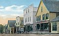
Main Street c. 1915
-
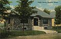
Public Library c. 1912
-
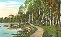
The boardwalk c. 1920


See also
 In Spanish: Rangeley (Maine) para niños
