
Rangeley Plantation, Maine facts for kids
Quick facts for kids
Rangeley Plantation, Maine
|
|
|---|---|
|
Plantation
|
|

Rangeley Plantation Town Offices
|
|

Rangeley Plantation, Maine
Location in Maine
|
|
| Country | United States |
| State | Maine |
| County | Franklin |
| Area | |
| • Total | 47.4 sq mi (122.8 km2) |
| • Land | 40.7 sq mi (105.4 km2) |
| • Water | 6.7 sq mi (17.4 km2) |
| Elevation | 1,959 ft (597 m) |
| Population
(2020)
|
|
| • Total | 184 |
| • Density | 3.882/sq mi (1.498/km2) |
| Time zone | UTC-5 (Eastern (EST)) |
| • Summer (DST) | UTC-4 (EDT) |
| ZIP code |
04970
|
| Area code(s) | 207 |
| FIPS code | 23-61875 |
| GNIS feature ID | 0582691 |
Rangeley Plantation is a small community located in Franklin County, Maine, United States. In Maine, a "plantation" is a type of local government for areas with fewer people. It's like a small town, but with a simpler way of managing things. According to the 2020 census, 184 people live here.
Contents
Exploring Rangeley Plantation's Geography
Rangeley Plantation covers an area of about 47.4 square miles (122.8 square kilometers). Most of this area, about 40.7 square miles (105.4 square kilometers), is land. The rest, about 6.7 square miles (17.4 square kilometers), is water.
Water Features and Natural Beauty
A big part of the northern area of Rangeley Plantation includes a section of Rangeley Lake. This beautiful lake is a popular spot for outdoor activities. You can also find Rangeley Lake State Park here, which is a great place to visit.
Understanding the Population of Rangeley Plantation
The number of people living in Rangeley Plantation has changed over many years. Here's a look at how the population has grown and shrunk since 1870:
| Historical population | |||
|---|---|---|---|
| Census | Pop. | %± | |
| 1870 | 45 | — | |
| 1880 | 64 | 42.2% | |
| 1890 | 58 | −9.4% | |
| 1900 | 98 | 69.0% | |
| 1910 | 190 | 93.9% | |
| 1920 | 159 | −16.3% | |
| 1930 | 79 | −50.3% | |
| 1940 | 63 | −20.3% | |
| 1950 | 44 | −30.2% | |
| 1960 | 39 | −11.4% | |
| 1970 | 52 | 33.3% | |
| 1980 | 69 | 32.7% | |
| 1990 | 103 | 49.3% | |
| 2000 | 123 | 19.4% | |
| 2010 | 189 | 53.7% | |
| 2020 | 184 | −2.6% | |
| U.S. Decennial Census | |||
People and Households in 2000
In the year 2000, there were 123 people living in Rangeley Plantation. These people lived in 57 different households, and 42 of these were families. Everyone living in the plantation at that time was identified as White.
Family Life and Age Groups
Out of all the households, about 15.8% had children under 18 living with them. Most households, 68.4%, were married couples. About 21.1% of households were made up of people living alone.
The population had a wide range of ages. About 13% of the people were under 18 years old. A large group, 43.1%, were between 45 and 64 years old. About 25.2% were 65 years or older. The average age was 54 years.
Income and Economy
In 2000, the average income for a household in Rangeley Plantation was $34,167 per year. For families, the average income was $37,679. The average income for each person was $18,370. A small number of families (4.9%) and people (6.7%) lived below the poverty line.
Images for kids
-
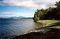
Swimming area at Rangeley Lake State Park

See also
 In Spanish: Rangeley Plantation para niños
