
Wilton (CDP), Maine facts for kids
Quick facts for kids
Wilton, Maine
|
|
|---|---|

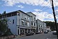
Downtown Wilton
|
|

Wilton (CDP), Maine
Location in Maine
|
|
| Country | United States |
| State | Maine |
| County | Franklin |
| Town | Wilton |
| Area | |
| • Total | 4.99 sq mi (12.92 km2) |
| • Land | 4.09 sq mi (10.60 km2) |
| • Water | 0.90 sq mi (2.33 km2) |
| Elevation | 551 ft (168 m) |
| Population
(2020)
|
|
| • Total | 2,071 |
| • Density | 506.11/sq mi (195.43/km2) |
| Time zone | UTC-5 (Eastern (EST)) |
| • Summer (DST) | UTC-4 (EDT) |
| ZIP code |
04294
|
| Area code(s) | 207 |
| FIPS code | 23-85815 |
| GNIS feature ID | 0578559 |
Wilton is a special area in Maine, United States. It's called a census-designated place (CDP). This means it's the main part of the larger town of Wilton in Franklin County.
In 2010, about 2,198 people lived in the Wilton CDP. The whole town of Wilton had a population of 4,116 people at that time.
Contents
Exploring Wilton's Location
The Wilton CDP is found in the southern-central part of the town of Wilton. Its exact spot is 44.591961 degrees north and -70.230456 degrees west.
Nearby Towns and Roads
The CDP stretches south to the town's border. It touches the town of Jay to the south.
You can find U.S. Route 2 in the southern part of Wilton. This road goes around the busy town center.
- US 2 goes northeast about 8 miles (13 km) to Farmington.
- It also goes west about 22 miles (35 km) to Rumford.
Maine State Route 4 also runs northeast with US 2 towards Farmington. But it turns off in Wilton and heads south about 6 miles (10 km) to the center of Jay.
Maine State Route 156 goes right through the middle of Wilton.
- It leads northwest about 13 miles (21 km) to Weld.
- It goes east about 10 miles (16 km) to US 2, past Farmington, near New Sharon.
Land and Water Features
The Wilton CDP covers a total area of about 4.99 square miles (12.9 square kilometers).
- Most of this area, about 4.09 square miles (10.6 square kilometers), is land.
- The rest, about 0.90 square miles (2.3 square kilometers), is water.
Most of the water is Wilson Pond, which is on the western side of the CDP. Water from Wilson Pond flows out through Wilson Stream. This stream drops about 80 feet (24 meters) in height as it goes through Wilton. This drop in elevation was important in the 1800s because it helped power factories that used water.
Who Lives in Wilton?
| Historical population | |||
|---|---|---|---|
| Census | Pop. | %± | |
| 2020 | 2,071 | — | |
| U.S. Decennial Census | |||
Let's look at the people who live in Wilton, based on information from the year 2000.
Population Numbers
In 2000, there were 2,290 people living in the Wilton CDP. These people lived in 958 households, and 614 of those were families.
The population density was about 561 people per square mile (217 people per square kilometer). There were 1,078 housing units, which means places where people could live.
Diversity in Wilton
The people living in Wilton in 2000 were mostly White (96.77%). There were also smaller numbers of Black or African American people (0.66%), Native American people (0.61%), and Asian people (1.00%). About 0.96% of the population was from two or more races. About 0.48% of the people were Hispanic or Latino.
Households and Families
Out of all the households, 30.8% had children under 18 living with them.
- 48.0% were married couples living together.
- 12.8% had a female head of household with no husband present.
- 35.9% were not families.
About 28.9% of all households had only one person living in them. And 12.9% of households had someone living alone who was 65 years old or older.
The average household had 2.39 people, and the average family had 2.91 people.
Age Groups
The population in Wilton was spread out across different age groups:
- 26.4% were under 18 years old.
- 8.3% were between 18 and 24 years old.
- 27.3% were between 25 and 44 years old.
- 24.7% were between 45 and 64 years old.
- 13.3% were 65 years old or older.
The median age was 38 years. This means half the people were younger than 38 and half were older. For every 100 females, there were about 88.5 males.
See also
- Wilton (condado de Franklin) para niños (This link goes to a kid-friendly article in Spanish about Wilton.)
Images for kids
-
Downtown Wilton
