
Farmingdale, Maine facts for kids
Quick facts for kids
Farmingdale, Maine
|
|
|---|---|

|
|

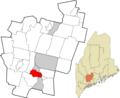
Location in Kennebec County and the state of Maine
|
|
| Country | United States |
| State | Maine |
| County | Kennebec |
| Incorporated | 1852 |
| Village | Farmingdale |
| Area | |
| • Total | 11.55 sq mi (29.91 km2) |
| • Land | 11.24 sq mi (29.11 km2) |
| • Water | 0.31 sq mi (0.80 km2) |
| Elevation | 230 ft (70 m) |
| Population
(2020)
|
|
| • Total | 2,995 |
| • Density | 267/sq mi (102.9/km2) |
| Time zone | UTC-5 (Eastern (EST)) |
| • Summer (DST) | UTC-4 (EDT) |
| ZIP code |
04344
|
| Area code(s) | 207 |
| FIPS code | 23-24635 |
| GNIS feature ID | 0566053 |
Farmingdale is a town in Kennebec County, Maine, USA. It is located in the northeastern part of the United States. In 2020, about 2,995 people lived there. Farmingdale is part of the larger Augusta area.
Contents
History of Farmingdale
Farmingdale became an official town in 1852. It was created by combining parts of nearby towns. These included South Hallowell, North Gardiner, and parts of East and West Gardiner.
Many businesses used to operate in Farmingdale. Most of them were located along the Kennebec River. A very important business was harvesting and selling ice. This ice was sold all over the world! The Knickerbocker Ice Company was the biggest ice company in the country. They had large buildings called ice-houses at Bowman's Point. The Knickerbocker Ice Company's building burned down in the late 1800s. Its chimney stood until 1911, when it was removed for a power plant.
Other businesses along the river included shipyards (where ships are built), brickyards (where bricks are made), pottery factories, and a glue factory. Over time, bigger cities like Gardiner, Hallowell, and Augusta grew more. Farmingdale never developed a large town center like those cities. Fires, floods, and changes in the economy caused many of the big businesses to close.
Today, Farmingdale is mostly a residential community. This means many people live here and travel to work in Augusta or other nearby cities. The town still has areas along the river that are more developed and rural areas further back. Two important buildings in Farmingdale are listed on the National Register of Historic Places. These are the Peter Grant House and the Capt. Nathaniel Stone House.
Geography of Farmingdale
Farmingdale is located in the southern part of Kennebec County. To the north, it borders the city of Hallowell. To the east, it borders the towns of Chelsea and Randolph. To the south, it borders the city of Gardiner and the town of West Gardiner. To the west, it borders the town of Manchester.
The Kennebec River forms the eastern edge of the town. Interstate 95, which is part of the Maine Turnpike, goes through the middle of Farmingdale. However, there are no direct exits to the town from this highway. U.S. Route 201 and Maine State Route 27 also pass through the eastern side of the town. They follow along the Kennebec River.
The town covers a total area of about 11.55 square miles (29.91 square kilometers). Most of this area, about 11.24 square miles (29.11 square kilometers), is land. The rest, about 0.31 square miles (0.80 square kilometers), is water. A special area called the Farmingdale census-designated place is in the eastern part of town. About two-thirds of the town's population lives in this area.
Population and People
| Historical population | |||
|---|---|---|---|
| Census | Pop. | %± | |
| 1860 | 896 | — | |
| 1870 | 859 | −4.1% | |
| 1880 | 789 | −8.1% | |
| 1890 | 821 | 4.1% | |
| 1900 | 848 | 3.3% | |
| 1910 | 823 | −2.9% | |
| 1920 | 819 | −0.5% | |
| 1930 | 1,044 | 27.5% | |
| 1940 | 1,197 | 14.7% | |
| 1950 | 1,449 | 21.1% | |
| 1960 | 1,941 | 34.0% | |
| 1970 | 2,423 | 24.8% | |
| 1980 | 2,535 | 4.6% | |
| 1990 | 2,918 | 15.1% | |
| 2000 | 2,804 | −3.9% | |
| 2010 | 2,956 | 5.4% | |
| 2020 | 2,995 | 1.3% | |
| U.S. Decennial Census | |||
In 2010, there were 2,956 people living in Farmingdale. These people lived in 1,259 households. About 807 of these households were families. The population density was about 263.9 people per square mile.
Most of the people in Farmingdale were White (96.3%). There were also smaller percentages of Black or African American, Native American, and Asian residents. About 1.3% of the population identified as Hispanic or Latino.
About 31% of households had children under 18 living with them. About 46.4% were married couples living together. About 13.7% of households had a female head with no husband present. Around 28.5% of all households had someone 65 years old or older living alone.
The average household size was 2.3 people. The average family size was 2.81 people. The population was spread out by age. About 24.9% were under 20 years old. About 18.1% were 65 years or older. The average age in Farmingdale was 41.6 years. The population was slightly more female (52.3%) than male (47.7%).
Economy
Farmingdale is mostly a commuter town. This means that many people who live in Farmingdale travel to other towns or cities for work. Even so, there are close to 300 small businesses located within Farmingdale itself.
Education
Farmingdale shares a school system with its neighbor, Hallowell. This system is called the Hall-Dale School System. It is part of a larger group of schools called Kennebec Intra-District Schools (KIDS) Regional School Unit 2. This group also includes the towns of Dresden, Monmouth, and Richmond.
Hallowell and Farmingdale operate three schools together:
- Hall-Dale Elementary School: This school is for students from Pre-Kindergarten to 4th grade. It is located in Hallowell and has about 389 students.
- Hall-Dale Middle School: This school is for students in 5th to 8th grade. It is located in Farmingdale and has about 201 students.
- Hall-Dale High School: This school is for students in 9th to 12th grade. It is also located in Farmingdale and has about 349 students.
Images for kids
-

The Capt. Nathaniel Stone House in Farmingdale.
-
A map showing Farmingdale's location in Kennebec County, Maine.
See also
 In Spanish: Farmingdale (Maine) para niños
