Plymouth County, Massachusetts facts for kids
Quick facts for kids
Plymouth County
|
||
|---|---|---|
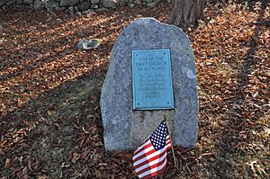
First Church Site marker, Men of Kent Cemetery, Meetinghouse Lane, Scituate, Massachusetts
|
||
|
||
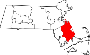
Location within the U.S. state of Massachusetts
|
||
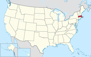 Massachusetts's location within the U.S. |
||
| Country | ||
| State | ||
| Founded | June 2, 1685 | |
| Seat | Plymouth and Brockton | |
| Largest city | Brockton | |
| Area | ||
| • Total | 1,093 sq mi (2,830 km2) | |
| • Land | 659 sq mi (1,710 km2) | |
| • Water | 434 sq mi (1,120 km2) 40%% | |
| Population
(2020)
|
||
| • Total | 530,819 | |
| • Density | 806.1/sq mi (311.2/km2) | |
| Time zone | UTC−5 (Eastern) | |
| • Summer (DST) | UTC−4 (EDT) | |
| Congressional districts | 4th, 8th, 9th | |
Plymouth County is a special area in the state of Massachusetts, located south of Boston. It's called a county, and it's where many people live. In 2020, about 530,819 people called Plymouth County home.
The county has two main "seats" or centers of government: Plymouth and Brockton. Plymouth County was created a very long time ago, in 1685. This was even before it became part of the larger Massachusetts Bay Colony. Today, Plymouth County is part of the big Boston area.
Contents
Exploring Plymouth County
Where is Plymouth County?
Plymouth County covers a total area of about 1,093 square miles. A big part of this area, about 434 square miles, is water! This means that about 40% of the county is covered by water. It is the third-largest county in Massachusetts when you count both land and water.
Neighboring Areas
Plymouth County shares borders with a few other counties:
- Norfolk County is to the north.
- Barnstable County is to the southeast.
- Bristol County is to the west.
Some towns in Plymouth County, like Hingham and Hull, are on the coast. They face Massachusetts Bay and share a water border with Suffolk County.
Special Natural Places
Plymouth County is home to some important protected natural areas:
- Boston Harbor Islands National Recreation Area (part of it)
- Massasoit National Wildlife Refuge
These places help protect nature and offer beautiful spots to visit.
Major Roads
Many important roads run through Plymouth County, connecting different towns and cities. These include major highways like Interstate 195 and Interstate 495, as well as many state routes.
 I‑195
I‑195 I‑495
I‑495 US 6
US 6 US 44
US 44 Route 3
 Route 3A
 Route 14
 Route 18
 Route 24
 Route 25
 Route 27
 Route 28
 Route 36
 Route 37
 Route 53
 Route 58
 Route 79
 Route 80
 Route 104
 Route 105
 Route 106
 Route 123
 Route 139
 Route 140
 Route 228
People of Plymouth County
Population Growth
Plymouth County has grown a lot over the years. Back in 1790, only about 29,512 people lived here. By 2020, the population had grown to over 530,000 people! This shows how much the area has developed.
| Historical population | |||
|---|---|---|---|
| Census | Pop. | %± | |
| 1790 | 29,512 | — | |
| 1800 | 30,073 | 1.9% | |
| 1810 | 35,169 | 16.9% | |
| 1820 | 38,136 | 8.4% | |
| 1830 | 43,044 | 12.9% | |
| 1840 | 47,373 | 10.1% | |
| 1850 | 55,697 | 17.6% | |
| 1860 | 64,768 | 16.3% | |
| 1870 | 65,365 | 0.9% | |
| 1880 | 74,018 | 13.2% | |
| 1890 | 92,700 | 25.2% | |
| 1900 | 113,985 | 23.0% | |
| 1910 | 144,337 | 26.6% | |
| 1920 | 156,968 | 8.8% | |
| 1930 | 162,311 | 3.4% | |
| 1940 | 168,824 | 4.0% | |
| 1950 | 189,468 | 12.2% | |
| 1960 | 248,449 | 31.1% | |
| 1970 | 333,314 | 34.2% | |
| 1980 | 405,437 | 21.6% | |
| 1990 | 435,276 | 7.4% | |
| 2000 | 472,822 | 8.6% | |
| 2010 | 494,919 | 4.7% | |
| 2020 | 530,819 | 7.3% | |
| 2023 (est.) | 535,308 | 8.2% | |
| U.S. Decennial Census 1790–1960 1900–1990 1990–2000 2010–2020 |
|||
Who Lives Here?
According to the 2010 census, most people in Plymouth County were white (85.5%). There were also significant numbers of Black or African American people (7.2%) and Asian people (1.2%). About 3.2% of the population was of Hispanic or Latino origin. Many families in the county have children under 18 living at home. The average age of people in Plymouth County was about 41 years old.
Media and News
Radio Stations
Plymouth County has several radio stations that broadcast different types of music and programs. Some of these stations are run by schools or colleges, offering unique content.
| Call sign | Frequency | City of license | Licensee | Format | Notes |
|---|---|---|---|---|---|
| WATD-FM | 95.9 FM | Marshfield | Marshfield Broadcasting Co., Inc. | Adult contemporary | |
| WBMS | 1460 AM | Brockton | Marshfield Broadcasting Co., Inc. | Adult contemporary | |
| WBIM-FM | 91.5 FM | Bridgewater | Bridgewater State University | College radio, alternative | |
| WPLM | 1390 AM | Plymouth | Plymouth Rock Broadcasting Co., Inc. | Various | Currently silent since February 15, 2024 |
| WPLM-FM | 99.1 FM | Plymouth | Plymouth Rock Broadcasting Co., Inc. | Adult contemporary | |
| WRPS | 88.3 FM | Rockland | Rockland Public Schools | High school radio | |
| WSMA | 90.5 FM | Scituate | Calvary Chapel of Twin Falls, Inc. | Religious | |
| WVBF | 1530 AM | Middleborough Center | Steven J. Callahan | Talking Information Center | |
| WWTA | 88.5 FM | Marion | Tabor Academy | High school radio | Defunct since April 1, 2014 |
| WZRM | 97.7 FM | Brockton | iHM Licenses, LLC | Spanish CHR |
Did you know that the very first radio broadcast in history happened in 1906? It was made from a place called Brant Rock in the town of Marshfield, right here in Plymouth County!
Newspapers
The Brockton Enterprise is the only daily newspaper published in Plymouth County. However, other newspapers, like The Quincy Patriot Ledger, also cover news from this area.
There are also many weekly newspapers that focus on local news in different towns:
- Abington Mariner (for Abington)
- Duxbury Clipper (for Duxbury)
- The Hingham Journal (for Hingham)
- Marshfield Mariner (for Marshfield)
- Old Colony Memorial (for Plymouth)
- Plympton-Halifax-Kingston Express (for Plympton, Halifax, and Kingston)
- Rockland Standard (for Rockland)
- Scituate Mariner (for Scituate)
- The Sentinel (for Marion and Rochester)
The Old Colony Memorial is very old! It was first published in 1822, making it the oldest weekly newspaper that has been continuously published in New England.
Towns and Cities
Plymouth County has two cities and many towns. Even though Plymouth is very large, it still uses a "town meeting" style of government, so it's recognized as a town.
Cities
- Bridgewater
- Brockton (one of the county seats)
Towns
Other Communities
Besides cities and towns, Plymouth County also has many smaller communities. Some are called "census-designated places" (CDPs), which are areas identified by the census bureau. There are also many other villages within the towns.
Census-designated places
- Bridgewater
- Cedar Crest
- Duxbury
- Green Harbor
- Hanson
- Hingham
- Kingston
- Marion Center
- Marshfield
- Marshfield Hills
- Mattapoisett Center
- Middleborough Center
- North Lakeville
- North Pembroke
- North Plymouth
- North Scituate
- Ocean Bluff-Brant Rock
- Onset
- The Pinehills
- Plymouth ("Plymouth Center")
- Scituate
- South Duxbury
- Wareham Center
- West Wareham
- Weweantic
- White Island Shores
Villages
See also
 In Spanish: Condado de Plymouth (Massachusetts) para niños
 | Anna J. Cooper |
 | Mary McLeod Bethune |
 | Lillie Mae Bradford |


