
Hull, Massachusetts facts for kids
Quick facts for kids
Hull
|
|||
|---|---|---|---|

Aerial view of Hull, 2010
|
|||
|
|||

Location in Plymouth County in Massachusetts
|
|||
| Country | United States | ||
| State | Massachusetts | ||
| County | Plymouth | ||
| Settled | 1622 | ||
| Incorporated | 1644 | ||
| Government | |||
| • Type | Open town meeting | ||
| Area | |||
| • Total | 26.9 sq mi (69.6 km2) | ||
| • Land | 2.8 sq mi (7.3 km2) | ||
| • Water | 24.1 sq mi (62.3 km2) | ||
| Elevation | 50 ft (15 m) | ||
| Population
(2020)
|
|||
| • Total | 10,072 | ||
| • Density | 3,573/sq mi (1,380/km2) | ||
| Time zone | UTC−5 (Eastern) | ||
| • Summer (DST) | UTC−4 (Eastern) | ||
| ZIP Code |
02045
|
||
| Area code(s) | 339/781 | ||
| FIPS code | 25-31645 | ||
| GNIS feature ID | 0618343 | ||


Hull is a town in Plymouth County, Massachusetts, United States. It is located on a narrow piece of land, called a peninsula, at the southern edge of Boston Harbor. In 2020, about 10,072 people lived there.
Hull is the smallest town in Plymouth County by land area. It is also the eleventh smallest in the entire state of Massachusetts. However, many people live there, making it quite crowded compared to the rest of Massachusetts.
Hull is famous for Nantasket Beach, a popular place for vacations. Many well-known people have spent their summers here. This includes Calvin Coolidge, who was a U.S. President, and John F. Fitzgerald, a former mayor of Boston. He was also the grandfather of Rose Kennedy.
Contents
History of Hull

The native Massachuset tribe called this area Nantasket. This word means "at the strait" or "low-tide place." Hull is made up of several islands connected by sandbars. These sandbars form the Nantasket Peninsula.
The Plymouth Colony set up a trading post here in 1621. They traded with the Wampanoag people. Hull was first settled in 1622 and became an official town in 1644. It was named after Kingston upon Hull in England.
In the early days, people in Hull mostly worked in fishing. They also traded goods and helped rescue things from shipwrecks. During the American Revolutionary War, General Benjamin Lincoln helped people leave Boston from Hull in 1778. Forts were built here to protect the area. For example, Fort Independence was built in 1776, and Fort Revere in 1901. Later, in 1927, Fort Duvall was built with very large guns.
Hull was originally part of Suffolk County. Later, it became part of Norfolk County. In 1803, Hull and Hingham decided to join Plymouth County.
Lifesaving has been a very important part of Hull's history. After the American Revolution, the Massachusetts Humane Society put rescue huts on Nantasket Beach. They also had boathouses for lifeboats in Hull. Joshua James (1826–1902) was Hull's most famous lifesaver. He became the first leader of the Pt. Allerton U.S. Life Saving Station in 1889. Joshua James and his teams saved over 1,000 people from shipwrecks! Today, the Hull Lifesaving Museum is in the old Life Saving Station.

Hull became a popular place for tourists. In 1825, the Sportsman Hotel opened on Nantasket Avenue. More hotels were built, and by 1840, steamboats carried people from Boston to Hull three times a day.
Later, Paragon Park was built as a safe and fun amusement park. It was known as a "marvel of fantasy." The park closed in 1984. Today, only the historic carousel and clock tower from Paragon Park remain on the boardwalk.
Geography of Hull

Hull is located on the narrow Nantasket Peninsula. This land sticks out into Massachusetts Bay. It is the southern point at the entrance to Boston Harbor. Hull is about 20 miles (32 km) from Boston by land. But by water, it's only about 5 miles (8 km) from Hull's Pemberton Point to City Point in South Boston. A boat ride from Pemberton Pier to Boston's Long Wharf takes about 20 minutes.
Hidden in Hull's bay is Hog Island, now called Spinnaker Island. This island used to have Hull's first high school. It also had Fort Duvall before World War II and a Nike missile site during the Cold War. Spinnaker Island now has homes and is connected to Hull by a small bridge.
Hull is separated from Cohasset and Hingham by the Weir River estuary. An estuary is where a river meets the sea. This area is very important for fish and other sea creatures. Over 100 types of birds also use the Weir River Estuary.
Black Rock Beach connects Hull to the mainland. Two bridges also link Hull to Hingham. Hull has many neighborhoods, including Green Hill, Nantasket Beach, Allerton, and Pemberton. The southern hills of Hull are made of volcanic rock from 600 million years ago. Other hills, like Sagamore and Telegraph Hill, are drumlins. These are small hills formed by glaciers about 14,000 years ago. The flat lands between the hills are tombolos, which are sandbars that connect islands to the mainland.

Telegraph Hill is home to Fort Revere Park. This park was once a defense site used in the early 1900s. It has an observation tower with great views of Boston Harbor and the coast.
Peddocks Island is also part of Hull. It is part of the Boston Harbor Islands State Park.
There are no major highways in Hull. Massachusetts Route 228 becomes Nantasket Avenue in Hull. The main way to enter Hull is on George Washington Boulevard, which connects to Route 3A. The MBTA offers bus service nearby in Hingham. The Greenbush Line commuter train has a station at Nantasket Junction. You can also take the MBTA Commuter Boat from Pemberton Point to Boston. The closest airport is Logan International Airport in Boston.
Population of Hull
As of 2020, about 10,072 people lived in Hull. The town has about 4,504 households. The average age of people in Hull is about 53.9 years old. Many people in Hull have a college degree or higher.
Education in Hull
Hull has its own school system for its students. About 1,250 students attend schools in Hull. A school board with five members makes decisions about the schools.
- The Lillian M. Jacobs School is for students from pre-kindergarten to fifth grade. It is located on Telegraph Hill.
- The Memorial Middle School is for students in sixth through eighth grade. It is near Bayside Park.
- Hull High School is at the end of the peninsula.
All three schools have recently been updated. Hull High's sports teams are called the Pirates, and their school colors are blue and gold. They play against other schools in the South Shore League. Their main rival is Cohasset High School. In 2015, 88 students graduated from Hull High School.
Hull does not have many private schools, but it does send students to regional vocational schools. These schools teach trades and skills. The closest private schools are in Hingham, and the nearest vocational high school is in Weymouth.
Famous People from Hull
Many interesting people have lived in Hull:
- Joy Browne, a psychologist and radio talk show host
- Johny Earle, who created the brand Johnny Cupcakes
- Joshua James, a famous lifesaver
- Joseph P. Kennedy Jr., the brother of President John F. Kennedy (he was born at his family's summer home in Hull)
- Richard Irving "Butch" Neal, a four-star general in the United States Marine Corps
- John Boyle O'Reilly, a journalist and poet
- Mary Boyle O'Reilly, a journalist and war reporter (John's daughter)
- Bernice de Pasquali, an opera singer
- Susanna Rowson, a novelist, poet, and playwright
Gallery
-
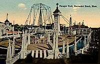
Paragon Park
-
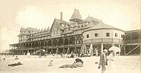
Hotel Nantasket and Auditorium
-
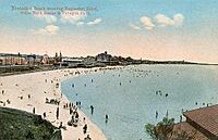
Nantasket Beach overview


International Connections
Hull is named after Kingston upon Hull in the United Kingdom. There is also a place called Hull in Quebec, Canada, which is also named after Kingston upon Hull.
See also
 In Spanish: Hull (Massachusetts) para niños
