Ocean Bluff-Brant Rock, Massachusetts facts for kids
Quick facts for kids
Ocean Bluff-Brant Rock, Massachusetts
|
|
|---|---|

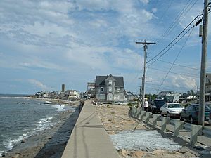
Ocean Bluff looking south
|
|

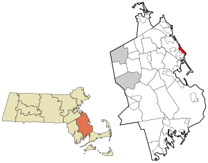
Location in Plymouth County in Massachusetts
|
|
| Country | United States |
| State | Massachusetts |
| County | Plymouth |
| Area | |
| • Total | 4.39 sq mi (11.37 km2) |
| • Land | 2.17 sq mi (5.63 km2) |
| • Water | 2.21 sq mi (5.74 km2) |
| Population
(2020)
|
|
| • Total | 4,744 |
| • Density | 2,181.15/sq mi (842.28/km2) |
| Time zone | UTC-5 (Eastern (EST)) |
| • Summer (DST) | UTC-4 (EDT) |
| Area code(s) | 781/339 |
| FIPS code | 25-50862 |
Ocean Bluff-Brant Rock is a special area in Plymouth County, Massachusetts, United States. It's called a census-designated place (CDP). This means it's a place that the government counts for population, but it's not an official town or city. It includes the neighborhoods of Ocean Bluff, Brant Rock, Fieldston, and Rexhame. These areas are all part of the larger town of Marshfield. In 2020, about 4,744 people lived here.
Contents
History of Ocean Bluff-Brant Rock
Early Inhabitants and Land Grants
Long ago, Native Americans lived in the Brant Rock and Ocean Bluff areas. These included members of the Wampanoag tribe, who are part of the larger Algonquian peoples. Many old Native American tools and items have been found here. The main road, now called Ocean Street, is a very old Native American path. A place called Blackman's Point was once a Native American camping spot.
In the 1630s, the Pilgrim settlers from Plymouth started giving out land in this area.
How Ocean Bluff Got Its Name
The Ocean Bluff area was first given to the Pilgrim governor. Around 1638, it was known as "Governor's Island." Later, in the 1600s, it became "Winter's Island." After some time, it was called Hewitt's Island or Hewitt's Point for many generations. Today, most people know it as "Ocean Bluff."
The Story of Brant Rock
Brant Rock was first called "Branch's Island." The name "Brant Rock" came about because of a large rock on the beach. Brant geese would often rest on this rock. For many years, from the 1600s to the late 1800s, people used the area for cutting salt marsh hay, grazing cattle, fishing, and hunting birds. In the late 1800s, it became a popular place for summer vacations, with many hotels and shops.
The "Spectacle Islands"
Hewitt's Island (Ocean Bluff) and Branch's Island (Brant Rock) were sometimes called the "Spectacle Islands." This was because, together, they looked like a pair of eyeglasses. After the Civil War, a barrier called the Green Harbor Dyke was built. This caused the nearby salt marshes to dry up. The "islands" were no longer surrounded by water, so they stopped being true islands.
A Big Moment in Radio History
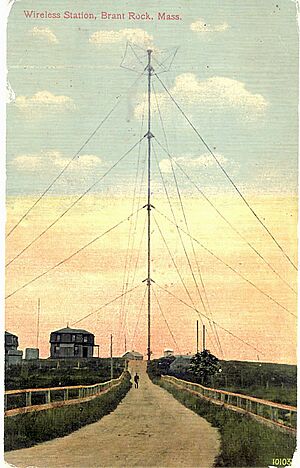
In January 1906, a scientist named Reginald Fessenden made history. He sent the first two-way radio message across the Atlantic Ocean. He used Morse code to send messages between his stations in Brant Rock and Machrihanish, Scotland. Before this, Marconi had only sent messages one way.
Then, on Christmas Eve, December 24, 1906, Fessenden did something even more amazing. From his Brant Rock Station, he made the first ever radio broadcast of music and entertainment! Radio operators on ships in the Atlantic heard him play "O Holy Night" on his violin and read from the Bible.
Geography and Beaches
Ocean Bluff and Brant Rock are located at 42°6′6″N 70°39′39″W / 42.10167°N 70.66083°W. They are part of the town of Marshfield.
This area covers about 11.3 square kilometers (4.39 square miles). About half of this area is land, and the other half is water.
Popular Beaches
Ocean Bluff and Brant Rock have five public beaches: Sunrise Beach, Ocean Bluff Beach, Brant Rock Beach, Blackman's Point, and Bluefish Cove. All the beaches along the Marshfield coast, from Green Harbor to Rexhame, were once known as "Marshfield Beach." In 1832, a court decided that all of "Marshfield Beach" was a "common." This meant it was open for everyone to use.
During the summer, many people enjoy skimboarding and surfing, especially at Sunrise Beach and Ocean Bluff.
Local Events and Weather
Brant Rock hosts an annual lobster festival on September 12. This area can experience flooding during high tide and strong storms. Large waves from storms like nor'easters can sometimes rise high above the sea wall.
Population and People
| Historical population | |||
|---|---|---|---|
| Census | Pop. | %± | |
| 2020 | 4,744 | — | |
| U.S. Decennial Census | |||
In 2000, there were about 5,100 people living in Ocean Bluff-Brant Rock. Most of the people living here were White. A small number were African American, Native American, or Asian.
About 32% of homes had children under 18 living there. The average age of people in the area was 38 years old.
Ocean Bluff-Brant Rock in Popular Culture
The final part of the 2018 movie The Equalizer 2 takes place in Brant Rock. This film stars Denzel Washington as Robert McCall, a former secret agent. It was the first time Denzel Washington played the same character in a movie sequel.
See also
 In Spanish: Ocean Bluff-Brant Rock para niños
 | John T. Biggers |
 | Thomas Blackshear |
 | Mark Bradford |
 | Beverly Buchanan |


