Plympton, Massachusetts facts for kids
Quick facts for kids
Plympton, Massachusetts
|
|||
|---|---|---|---|
| Town of Plympton | |||

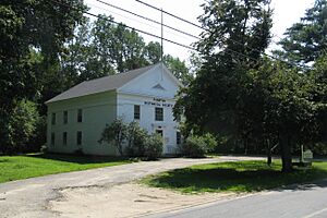
Plympton Historical Society
|
|||
|
|||

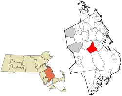
Location in Plymouth County in Massachusetts
|
|||
| Country | United States | ||
| State | Massachusetts | ||
| County | Plymouth | ||
| Settled | 1662 | ||
| Incorporated | 1707 | ||
| Government | |||
| • Type | Open town meeting | ||
| Area | |||
| • Total | 15.1 sq mi (39.2 km2) | ||
| • Land | 14.8 sq mi (38.3 km2) | ||
| • Water | 0.4 sq mi (0.9 km2) | ||
| Elevation | 105 ft (32 m) | ||
| Population
(2020)
|
|||
| • Total | 2,930 | ||
| • Density | 194.0/sq mi (74.74/km2) | ||
| Time zone | UTC-5 (Eastern) | ||
| • Summer (DST) | UTC-4 (Eastern) | ||
| ZIP code |
02367
|
||
| Area code(s) | 339 / 781 | ||
| FIPS code | 25-54415 | ||
| GNIS feature ID | 0619472 | ||
| Website | www.town.plympton.ma.us | ||
Plympton is a small town in Plymouth County, Massachusetts, in the United States. In 2020, about 2,930 people lived there. A famous person named William Bradford, who was a United States senator, was born in Plympton.
Contents
History of Plympton
Plympton was first settled in 1662. It started as the western part of Plymouth. The original area of Plympton was much larger than it is today. It included all of what are now the towns of Carver and Halifax. It also included small parts of Kingston and Middleborough.
The town officially became its own town in 1707. It was named after a place called Plympton in England. Later, in 1734, Halifax became a separate town. Carver also became its own town in 1790. The borders of Plympton that we know today were set in 1862.
Long ago, most people in Plympton were farmers. They grew their own food and lived off the land. Later, during the Industrial Revolution, factories came to the town. These factories made things like shoes and shovels. There were also mills that processed lumber and cotton. Today, Plympton is mostly a quiet, rural town. Most people live in homes there, and there isn't much industry.
One of the most famous people from Plympton was Deborah Sampson. She was born in the town in 1760. She is known for pretending to be a man so she could fight in the American Revolution. That was a very brave thing to do!
A new Sysco distribution plant has recently been built near U.S. Route 44. This plant helps deliver food products.
Geography of Plympton
Plympton covers about 15.1 square miles (39.2 square kilometers). Most of this area is land, about 14.8 square miles (38.3 square kilometers). A small part, about 0.3 square miles (0.9 square kilometers), is water.
Plympton is surrounded by other towns. To the northwest is Halifax. To the north is Pembroke. Kingston is to the northeast. Carver is to the southeast, and Middleborough is to the southwest. Plympton is about 35 miles (56 km) south of Boston. It is also east of Providence, Rhode Island.
Plympton is a very rural town. Much of its land is covered by beautiful forests. The northern part of town touches Silver Lake. This lake also stretches into Kingston, Pembroke, and along the Halifax border. The Winnetuxet River flows through the town. Many other small streams and ponds are also found here. Plympton also has its own town forest. This forest is a special area for nature and conservation.
Getting Around Plympton
A new highway, U.S. Route 44, goes through the southeastern part of Plympton. Other main roads, Route 58 and Route 106, also pass through the town. Route 106 crosses the northern part of Plympton. Route 58 goes from the southeast to the northwest.
If you want to travel to Boston by train, the Kingston/Plymouth Line of the MBTA's Commuter Rail goes through Plympton. The closest train stop is in Halifax.
For air travel, the nearest small airport is Plymouth Municipal Airport. The closest major airport for national and international flights is Logan International Airport in Boston. However, the closest airport overall is Cranland Municipal Airport in Hanson, MA.
People in Plympton
| Historical population | ||
|---|---|---|
| Year | Pop. | ±% |
| 1850 | 927 | — |
| 1860 | 994 | +7.2% |
| 1870 | 804 | −19.1% |
| 1880 | 694 | −13.7% |
| 1890 | 597 | −14.0% |
| 1900 | 488 | −18.3% |
| 1910 | 561 | +15.0% |
| 1920 | 469 | −16.4% |
| 1930 | 511 | +9.0% |
| 1940 | 532 | +4.1% |
| 1950 | 697 | +31.0% |
| 1960 | 821 | +17.8% |
| 1970 | 1,224 | +49.1% |
| 1980 | 1,974 | +61.3% |
| 1990 | 2,384 | +20.8% |
| 2000 | 2,637 | +10.6% |
| 2010 | 2,820 | +6.9% |
| 2020 | 2,930 | +3.9% |
| 2022* | 2,923 | −0.2% |
| * = population estimate. Source: United States Census records and Population Estimates Program data. |
||
In 2000, there were 2,637 people living in Plympton. These people lived in 854 households, and 737 of these were families. About 43% of households had children under 18 living with them. Most households, about 76%, were married couples living together.
The people in Plympton are spread out in age. About 28% of the population was under 18 years old. About 29% were between 25 and 44 years old. Another 28% were between 45 and 64 years old. About 6% of the people were 65 years or older. The average age in Plympton was 38 years.
Schools in Plympton
Plympton is part of the Silver Lake Regional School District. This district also includes the towns of Kingston and Halifax. Each town has its own elementary school. Then, a middle school and a high school are shared by all three towns.
Plympton has the Dennett Elementary School. Students from kindergarten through sixth grade go to school here. Both the Silver Lake Regional Middle School and the Silver Lake Regional High School are in the nearby town of Kingston. The sports teams for the Silver Lake schools are called the Lakers. Their team colors are red and silver. There are no private schools in Plympton.
See also
In Spanish: Plympton (Massachusetts) para niños
 | Georgia Louise Harris Brown |
 | Julian Abele |
 | Norma Merrick Sklarek |
 | William Sidney Pittman |


