Carver, Massachusetts facts for kids
Quick facts for kids
Carver, Massachusetts
|
|||
|---|---|---|---|

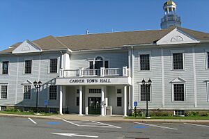
Town Hall
|
|||
|
|||

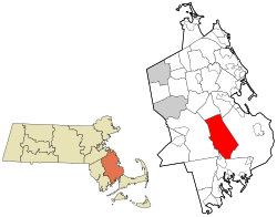
Location in Plymouth County in Massachusetts
|
|||
| Country | United States | ||
| State | Massachusetts | ||
| County | Plymouth | ||
| Settled | 1660 | ||
| Incorporated | 1790 | ||
| Government | |||
| • Type | Open town meeting | ||
| Area | |||
| • Total | 39.7 sq mi (102.9 km2) | ||
| • Land | 37.4 sq mi (96.9 km2) | ||
| • Water | 2.3 sq mi (6.0 km2) | ||
| Elevation | 92 ft (28 m) | ||
| Population
(2020)
|
|||
| • Total | 11,645 | ||
| • Density | 293.10/sq mi (113.17/km2) | ||
| Time zone | UTC-5 (Eastern) | ||
| • Summer (DST) | UTC-4 (Eastern) | ||
| ZIP code |
02330
|
||
| Area code(s) | 508 / 774 | ||
| FIPS code | 25-11665 | ||
| GNIS feature ID | 0618337 | ||
| Website | www.carverma.org | ||
Carver is a town in Plymouth County, Massachusetts, United States. In 2020, about 11,645 people lived there. The town is named after John Carver, who was the first governor of the Plymouth Colony.
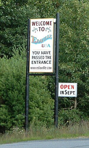
Carver is famous for two fun places to visit. One is Edaville USA, a theme park with trains. The other is King Richard's Faire, which is a big renaissance fair that brings the 16th century to life! It's the largest and oldest fair of its kind in New England.
Contents
History of Carver
Archaeologists have found signs that people lived in Carver for a very long time. They discovered tools and even a human burial site at Annasnappet Pond. This shows people were here from 10,000 to 1,000 years ago.
How Carver Became a Town
Carver became its own town in 1790. Before that, it was part of Plympton, Massachusetts. People in Carver lived too far away to easily go to church in Plympton. So, they decided to form their own town. They named it after John Carver, the first governor of the Plymouth Colony.
Early Industries
At first, Carver was mostly a farming town. But by the 1730s, it became known for its iron ore. This ore came from the swampy areas and was used to make cooking tools. The first iron factory, "Pope's Point Furnace," started in 1732. It used materials from the bogs and Sampson's Pond to make iron for about 100 years.
For the next 150 years, other important jobs in Carver included sheep shearing and working in lumber mills.
Growth of Villages
Most people lived in small villages like South Carver, North Carver, and Wenham (which is now East Carver). There was also a place called South Meadow. Each village had at least one school.
The Cranberry Boom
As the demand for iron went down in the late 1800s, Carver found a new use for its swampy land: cranberry farming! Farmers started growing cranberries in the 1870s. By 1900, Carver farmers grew one-fifth of all the cranberries in the United States.
In 1920, a railroad line connected Carver to New York and Boston. This helped the town grow even more.
Savery's Avenue and Modern Carver
The money from the iron industry helped build many nice homes, some of which you can still see today. Carver is also home to Savery's Avenue. This was America's first divided highway, opened in 1860 by William Savery. Trees were planted between the roads and along the sides for "shade and ornament."
By the 1940s, Carver had the biggest cranberry harvest in the world. Today, cranberry farming is still a very important business in town. Because so much land is used for cranberry bogs, Carver has kept its peaceful, rural feel. In recent years, many cranberry bogs have been replanted with new types of cranberries.
Fun Attractions in Carver
Carver has two famous places that attract visitors:
- Edaville Railroad: This train attraction opened in 1949. It's been a popular family spot, especially known for its Christmas lights festival. It was sold in 1991 and almost closed, but it's doing well again now.
- King Richard's Faire: This fair brings the 16th century to life! It's open on weekends in September and October. It's New England's largest Renaissance fair.
Did you know that professional wrestler Mike Bennett is from Carver?
Geography of Carver
Carver covers about 103 square kilometers (about 40 square miles). Most of this area is land, with about 6 square kilometers (2.3 square miles) being water. The town is well-known for its many cranberry bogs.
Neighboring Towns and Location
Carver shares its borders with several towns:
- To the north: Plympton
- To the northeast: Kingston
- To the east: Plymouth
- To the south: Wareham
- To the west: Middleborough
Carver is about 45 miles (72 km) south-southeast of Boston. It's also about 38 miles (61 km) east of Providence, Rhode Island.
Natural Features
Carver's landscape has many small brooks, rivers, and ponds, like Vaughn Pond and Bates Pond. Most of these waters flow into Buzzards Bay. However, some in the northern part of town flow towards Cape Cod Bay or Narragansett Bay.
The town has many pine and cedar trees. A large part of Myles Standish State Forest is in the southeast corner of Carver. There's also a big cedar swamp in the middle of town. Carver also has a campground, a club for sportsmen, and a small town park.
Population of Carver
| Historical population | ||
|---|---|---|
| Year | Pop. | ±% |
| 1850 | 1,186 | — |
| 1860 | 1,186 | +0.0% |
| 1870 | 1,092 | −7.9% |
| 1880 | 1,039 | −4.9% |
| 1890 | 994 | −4.3% |
| 1900 | 1,104 | +11.1% |
| 1910 | 1,668 | +51.1% |
| 1920 | 891 | −46.6% |
| 1930 | 1,381 | +55.0% |
| 1940 | 1,469 | +6.4% |
| 1950 | 1,530 | +4.2% |
| 1960 | 1,949 | +27.4% |
| 1970 | 2,420 | +24.2% |
| 1980 | 6,988 | +188.8% |
| 1990 | 10,590 | +51.5% |
| 2000 | 11,163 | +5.4% |
| 2010 | 11,509 | +3.1% |
| 2020 | 11,645 | +1.2% |
| 2022* | 11,626 | −0.2% |
| * = population estimate. Source: United States Census records and Population Estimates Program data. |
||
In 2000, there were 11,163 people living in Carver. About 3,984 households were in the town. Many families lived there, with 63.3% being married couples. About 36.6% of households had children under 18. The average household had 2.80 people.
The median age in Carver was 37 years old. About 27.3% of the population was under 18.
Education in Carver
Carver has its own school system. It is managed by a school committee and a superintendent.
Carver Public Schools
There are two main schools in Carver:
- Carver Elementary School: This school is for students from pre-kindergarten to fifth grade.
- Carver Middle-High School: This school serves students from sixth to twelfth grade.
Other School Choices
Students in Carver also have other options for high school. They can choose to go to:
- Old Colony Regional Vocational Technical High School in Rochester.
- Norfolk County Agricultural High School in Walpole.
- Bristol County Agricultural High School in Dighton.
There are no private schools in Carver itself. The closest private schools are in nearby towns like Kingston, Lakeville, and Taunton.
School Transportation
Carver operates its own bus system for students. They provide buses for Carver schools and for students going to most out-of-district schools. However, they do not provide transportation for Old Colony Regional.
Transportation in Carver
U.S. Route 44 runs through the northern part of Carver. This is a divided highway that connects to Route 3 in Plymouth. The highway was recently made longer. It now extends a few miles past the Carver/Wareham town line.
The closest major airports are:
- Logan International Airport in Boston.
- T. F. Green Airport in Warwick, Rhode Island. Many residents prefer T.F. Green because security wait times are often shorter.
See also
 In Spanish: Carver (Massachusetts) para niños
 | Delilah Pierce |
 | Gordon Parks |
 | Augusta Savage |
 | Charles Ethan Porter |


