Mattapoisett, Massachusetts facts for kids
Quick facts for kids
Mattapoisett, Massachusetts
|
||
|---|---|---|
|
Town
|
||

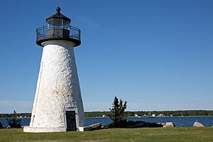
Ned's Point Light
|
||
|
||

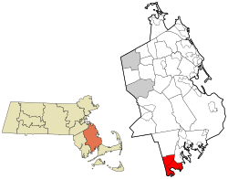
Location in Plymouth County in Massachusetts
|
||
| Country | United States | |
| State | Massachusetts | |
| County | Plymouth | |
| Settled | 1750 | |
| Incorporated | May 21, 1857 | |
| Government | ||
| • Type | Open town meeting | |
| Area | ||
| • Total | 24.2 sq mi (62.6 km2) | |
| • Land | 17.4 sq mi (45.0 km2) | |
| • Water | 6.8 sq mi (17.6 km2) | |
| Elevation | 25 ft (8 m) | |
| Population
(2020)
|
||
| • Total | 6,508 | |
| • Density | 269.26/sq mi (103.96/km2) | |
| Time zone | UTC−5 (Eastern) | |
| • Summer (DST) | UTC−4 (Eastern) | |
| ZIP Code |
02739
|
|
| Area code(s) | 508/774 | |
| FIPS code | 25-39450 | |
| GNIS feature ID | 0619471 | |
| Website | www.mattapoisett.net | |
Mattapoisett is a town located in Plymouth County, Massachusetts, in the United States. In 2020, about 6,508 people lived there. The town is part of the South Coast region of Massachusetts. This area includes towns and cities around Buzzards Bay.
Contents
History of Mattapoisett
Mattapoisett was bought in 1664 by Governor William Brenton. He bought it from a Wampanoag chief named Metacomet, also known as King Philip. The town was settled in 1750 and became an official town in 1857. Before that, it was part of Rochester.
The name Mattapoisett comes from the Massachusett language. It means "a place of resting." There is proof that Wampanoag people lived here before European settlers arrived.
Whaling and Shipbuilding
In the past, Mattapoisett was famous for building ships, especially for whaling. From 1740 to the 1870s, about 400 ships were built here. One famous ship was the Acushnet. The author Herman Melville sailed on this ship. He later wrote the famous book Moby-Dick.
The last whaling ship built in Mattapoisett was the Wanderer in 1878. Around this time, oil was found in Pennsylvania. This discovery made whaling less important, and the industry slowly ended.
From Whaling to Tourism
After whaling stopped, Mattapoisett became a popular summer vacation spot. Many rich people from New York and Boston came to visit. Today, Mattapoisett is mostly a suburban town. Many people live here and travel to nearby cities for work. It also remains a popular place for summer visitors.
Geography of Mattapoisett
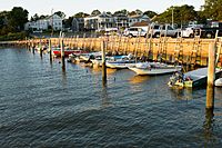
Mattapoisett covers about 62.6 square kilometers (24.2 square miles). A large part of this area, about 17.6 square kilometers (6.8 square miles), is water. The Mattapoisett River flows through the town and into Mattapoisett Harbor. This harbor is part of Buzzards Bay.
The town has a swamp called Haskell Swamp. The main part of town around the harbor is called The Village. There is also a state wildlife area called Nasketucket Bay State Reservation.
Mattapoisett has four beaches and two parks along the water. You can also find Ned Point Light here. This lighthouse was built in 1837 and is a historic landmark.
Nearby Towns
Mattapoisett is in the southwest part of Plymouth County. It shares borders with Fairhaven to the southwest and Acushnet to the northwest. To the north is Rochester, and to the east is Marion. Buzzards Bay is to the south.
Transportation in Mattapoisett
Interstate 195 goes through Mattapoisett. U.S. Route 6 is the main local road. There is an exit on I-195 for Mattapoisett.
For longer trips, you can find bus services in New Bedford. The closest airports for national flights are T. F. Green Airport in Rhode Island. For international flights, you can go to Logan International Airport in Boston.
Population and People
In 2010, there were 6,045 people living in Mattapoisett. Most people in the town are White. About 23.9% of the population was under 18 years old. The average age in Mattapoisett was 42 years.
Education in Mattapoisett
Mattapoisett is part of the Old Rochester Regional School District. This district also includes the towns of Marion and Rochester.
Local Schools
- The Center School is for students from pre-kindergarten to third grade.
- The Old Hammondtown School is for students in grades 4–6.
- Students in seventh and eighth grade go to Old Rochester Regional Junior High School.
- High school students attend Old Rochester Regional High School.
Both regional schools are located in Mattapoisett. The high school's mascot is the bulldog, and their colors are red and white.
Other School Options
Some high school students can choose to go to Old Colony Regional Vocational Technical High School in Rochester. This school teaches job skills. There are also private schools nearby, like Tabor Academy in Marion.
Notable People from Mattapoisett
Many interesting people have connections to Mattapoisett:
- Oliver Wendell Holmes Jr. (1841–1935) – A very important judge on the U.S. Supreme Court.
- Francis Davis Millet (1848–1912) – An artist who was born in Mattapoisett. He sadly died on the Titanic.
- Milton Silveira (1929–2013) – He was the Chief Engineer for NASA.
- Geoff Smith (1953) – A runner who won the Boston Marathon twice.
- Sam Waterston (born 1940) – A famous actor who has won awards.
See also
 In Spanish: Mattapoisett para niños
 | Tommie Smith |
 | Simone Manuel |
 | Shani Davis |
 | Simone Biles |
 | Alice Coachman |


