Marshfield (CDP), Massachusetts facts for kids
Quick facts for kids
Marshfield, Massachusetts
|
|
|---|---|

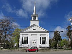
First Congregational Church
|
|

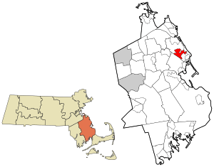
Location in Plymouth County in Massachusetts
|
|
| Country | United States |
| State | Massachusetts |
| County | Plymouth |
| Area | |
| • Total | 5.13 sq mi (13.28 km2) |
| • Land | 5.05 sq mi (13.09 km2) |
| • Water | 0.08 sq mi (0.20 km2) |
| Elevation | 16 ft (5 m) |
| Population
(2020)
|
|
| • Total | 4,653 |
| • Density | 920.84/sq mi (355.54/km2) |
| Time zone | UTC-5 (Eastern (EST)) |
| • Summer (DST) | UTC-4 (EDT) |
| ZIP codes |
02000-02099
|
| Area code(s) | 781 |
| FIPS code | 25-38820 |
| GNIS feature ID | 0615217 |
Marshfield is a special kind of community called a census-designated place (CDP). It is located within the larger town of Marshfield, Massachusetts. This area is found in Plymouth County, which is part of the state of Massachusetts in the United States. In 2020, about 4,653 people lived here.
Contents
Exploring Marshfield's Location
Marshfield is located at specific coordinates: 42.094577 degrees north and 70.709485 degrees west. This helps pinpoint its exact spot on a map.
Land and Water Area
According to the United States Census Bureau, Marshfield covers a total area of about 13.4 square kilometers (5.13 square miles). Most of this area, about 13.2 square kilometers (5.05 square miles), is land. A smaller part, about 0.2 square kilometers (0.08 square miles), is water. This means only a small percentage (around 1.55%) of Marshfield is covered by water.
Who Lives in Marshfield?
| Historical population | |||
|---|---|---|---|
| Census | Pop. | %± | |
| 2020 | 4,653 | — | |
| U.S. Decennial Census | |||
Let's look at the people who call Marshfield home. In 2000, there were 4,246 people living in this community. These people made up 1,686 households and 1,129 families.
Population Density
The population density was about 322 people per square kilometer (834 people per square mile). This tells us how many people live in a certain amount of space. There were also 1,742 housing units, with about 132 units per square kilometer (342 units per square mile).
Diversity in Marshfield
Most of the people in Marshfield in 2000 were White, making up about 97.83% of the population. Other groups included Black or African American (0.52%), Native American (0.14%), and Asian (0.45%). A small number of people were from other races or from two or more races. About 0.68% of the population was Hispanic or Latino.
Households and Families
Out of all the households, about 31.5% had children under 18 living with them. More than half, 54.4%, were married couples living together. About 8.8% of households had a female head with no husband present. Around 33.0% were non-family households.
Many households (28.8%) were made up of individuals living alone. About 14.8% of these individuals were 65 years old or older. The average household had about 2.52 people, and the average family had about 3.14 people.
Age Groups in Marshfield
The population in Marshfield is made up of different age groups. About 24.3% of the people were under 18 years old. Around 6.3% were between 18 and 24, and 29.9% were between 25 and 44. People aged 45 to 64 made up 26.3% of the population. Finally, about 13.2% were 65 years old or older. The average age in Marshfield was 39 years.
For every 100 females, there were about 91.7 males. If we look at people 18 and over, for every 100 females, there were about 88.7 males.
Income and Economy
In 2000, the average income for a household in Marshfield was about $60,037. For families, the average income was higher, around $74,531. The average income per person in the CDP was $25,656.
A small percentage of families (4.1%) and the overall population (6.5%) lived below the poverty line. This included 5.8% of those under 18 and 7.4% of those aged 65 or older.
See also
 In Spanish: Marshfield (condado de Plymouth) para niños
 | Selma Burke |
 | Pauline Powell Burns |
 | Frederick J. Brown |
 | Robert Blackburn |

