
Nantucket facts for kids
Quick facts for kids
Nantucket, Massachusetts
|
|||
|---|---|---|---|
| Town and County of Nantucket | |||
 |
|||
|
|||

Location of Nantucket in Massachusetts
|
|||

Nantucket, Massachusetts
Location in Massachusetts

Nantucket, Massachusetts
Location in the United States
|
|||
| Country | United States | ||
| State | Massachusetts | ||
| Settled | 1641 | ||
| Incorporated | 1671 | ||
| Government | |||
| • Type | Open town meeting and consolidated town and county | ||
| Area | |||
| • Total | 105.3 sq mi (272.6 km2) | ||
| • Land | 47.8 sq mi (123.8 km2) | ||
| • Water | 57.5 sq mi (148.8 km2) | ||
| Elevation | 30 ft (9 m) | ||
| Population
(2020)
|
|||
| • Total | 14,255 | ||
| • Density | 308.6/sq mi (115.1/km2) | ||
| Time zone | UTC−5 (Eastern) | ||
| • Summer (DST) | UTC−4 (Eastern) | ||
| ZIP Codes |
02554, 02564, 02584
|
||
| Area code(s) | 508 | ||
| FIPS code | 25-43790 | ||
| GNIS feature ID | 0619376 | ||
| Website | www.nantucket-ma.gov | ||


Nantucket is a beautiful island in Massachusetts, USA. It is located about 30 miles (48 km) south of the Cape Cod peninsula. Nantucket, along with the smaller islands of Tuckernuck and Muskeget, forms the Town and County of Nantucket. This means the island has a combined town and county government. It is the southeasternmost town in both Massachusetts and the New England region. The name "Nantucket" comes from old Algonquian names for the island.
Nantucket is a very popular place for tourists and people who want to spend their summers there. Because of all the visitors, the island's population can grow to about 80,000 people during the summer months! It is also known for its expensive homes. In 2018, the average price for a single-family home was $2.3 million.
The National Park Service has called Nantucket a "National Historic Landmark District." This means it is a special place that shows what a New England seaport town looked like in the late 1700s and early 1800s.
Contents
History of Nantucket Island

What Does "Nantucket" Mean?
The name Nantucket likely comes from a Wampanoag word. This word was written in different ways, like natocke or nantican. It is part of a Wampanoag story about how Martha's Vineyard and Nantucket were created. We are not completely sure what the word means. Some say it might mean "far away island" or "sandy, sterile soil that no one wants." The Wampanoag language is an Eastern Algonquian language spoken in southern New England.
Nantucket's nickname is "The Little Grey Lady of the Sea." This name comes from how the island looks from the ocean when it is covered in fog.
Early European Settlers Arrive
The first European settlement in this area was on the nearby island of Martha's Vineyard. It was started by an English merchant named Thomas Mayhew in 1641. Thomas Mayhew gained control of Martha's Vineyard, Nantucket, and other islands. He brought families to settle the area. He also made agreements with the Wampanoag people, who were the original inhabitants of Nantucket. These agreements helped keep the region peaceful during King Philip's War.
More settlers arrived, and they welcomed Native American groups who came to the island seasonally. These groups would fish and collect whales that washed ashore. Nantucket was part of New York until 1691. Then, it became part of Massachusetts and was made into Nantucket County.
Who Were the First Nantucket Settlers?
In 1659, Thomas Mayhew sold his share of the island to a group of investors. This group was led by Tristram Coffin. The "nine original purchasers" were Tristram Coffin, Peter Coffin, Thomas Macy, Christopher Hussey, Richard Swain, Thomas Barnard, Stephen Greenleaf, John Swain, and William Pile. These men are seen as the founding fathers of Nantucket. Many people on the island today are related to these families.
More people, like sailors and tradesmen, started to move to Nantucket. At first, the settlers focused on farming and raising sheep. However, there were too many animals, and the farms became difficult to manage. So, the islanders soon started looking to the sea for their living.
.jpg)
Before 1795, the main town on the island was called Sherburne. The first settlement was near Capaum Pond. This pond used to be a small harbor. But over time, its entrance filled with sand. This forced the settlers to take apart their houses and move them two miles northeast to where the town is today. In 1795, the town's name was officially changed to "Town of Nantucket."
Nantucket's Whaling Industry
The whaling industry on Nantucket began very early. In 1672, a type of whale called a "scragg" entered the harbor. Settlers chased and killed it. This event marked the start of Nantucket's famous whaling industry. The "scragg whale" was likely the gray whale.
In the early 1700s, whaling was done from small boats launched from the island's shores. These boats were about seven meters long. They were mostly rowed by Wampanoag people, who worked to pay off debts. A typical boat crew had five Wampanoag rowers and one white Nantucketer steering. Without the Native American population, who were more numerous than white settlers until the 1720s, Nantucket would not have become a successful whaling port.
Nantucket relied heavily on trade with Britain because of its whaling business. This led the island's leaders to try and stay neutral during the American Revolutionary War. They did not want to pick a side between the British and the American Patriots.
Herman Melville wrote about Nantucket's importance in whaling in his famous book Moby-Dick. He said, "Two thirds of this terraqueous globe are the Nantucketer's. For the sea is his; he owns it, as Emperors own empires." The characters Ahab and Starbuck in Moby-Dick are both from Nantucket. The real-life event that inspired Melville's novel was the last voyage of the Nantucket whaling ship Essex.
The island faced many economic problems. A "Great Fire" on July 13, 1846, made things much worse. The fire was fueled by whale oil and wood. It destroyed about 40 acres (16 hectares) of the main town. Hundreds of people lost their homes and became very poor, causing many to leave the island.
By 1850, whaling was slowing down. Nantucket's whaling industry was overtaken by New Bedford. Nantucket's harbor also became too shallow for large whaling ships. New Bedford, however, had a deep-water port. Also, railroads made mainland ports like New Bedford more appealing. It was easier to transport whale oil by train from there. The American Civil War finally ended the island's whaling industry. Most of the remaining whaling ships were destroyed by Confederate ships.
Nantucket's Later History
Because many people left, the island remained undeveloped and isolated until the mid-1900s. This isolation actually helped keep many of the old buildings from before the Civil War safe. By the 1950s, smart developers started buying land and restoring the old buildings. They turned Nantucket into a fancy place for wealthy people from the Northeastern United States.
In 1977, Nantucket and towns on Martha's Vineyard thought about leaving Massachusetts. This was because of a proposed change to the state's constitution. It would have reduced the number of representatives the islands had in the state government. However, these efforts were not successful.
Geography and Landscape

Nantucket County has a total area of about 304 square miles (787 sq km). Most of this area, about 85%, is water. The island of Nantucket itself is about 47.8 square miles (123.8 sq km) of land. The ocean area between Nantucket, Martha's Vineyard, and Cape Cod is called Nantucket Sound. Some of the highest points on the island are Altar Rock (100 ft or 30 m), Saul's Hill (102 ft or 31 m), and Sankaty Head (92 ft or 28 m).

Nantucket was formed by a huge sheet of ice called the Laurentide Ice Sheet during the last Ice Age. As the ice melted and sea levels rose, the island took its current shape. The low ridge on the northern part of the island was formed by rocks and dirt left behind by the melting glacier. The southern part of the island is a flat area made of sand and gravel washed out from the glacier. Nantucket became an island when rising sea levels covered the land connection to the mainland, about 5,000–6,000 years ago.
The entire island, including Tuckernuck and Muskeget, makes up the Town and County of Nantucket. The main town, also called Nantucket, is located at the western end of Nantucket Harbor. Other important places on the island include Madaket, Surfside, Polpis, Wauwinet, Miacomet, and Siasconset (often called "'Sconset").
Climate and Weather
Nantucket has a climate that is influenced a lot by the Atlantic Ocean. This helps keep temperatures moderate throughout the year. In January, the coldest month, average high temperatures are around 39.5°F (4.2°C). In July and August, the warmest months, average high temperatures are around 75°F (24°C).
Nantucket gets about 41 inches (104 cm) of rain each year, spread fairly evenly. Like many places near the ocean, Nantucket has many cloudy or overcast days, especially outside of summer. The hottest temperature ever recorded was 100°F (38°C) on August 2, 1975. The coldest temperature ever recorded was -3°F (-19°C) on December 31, 1962, and January 16, 2004.
| Climate data for Nantucket, Massachusetts (Nantucket Memorial Airport) 1991–2020 normals, extremes 1948–present | |||||||||||||
|---|---|---|---|---|---|---|---|---|---|---|---|---|---|
| Month | Jan | Feb | Mar | Apr | May | Jun | Jul | Aug | Sep | Oct | Nov | Dec | Year |
| Record high °F (°C) | 63 (17) |
59 (15) |
66 (19) |
83 (28) |
85 (29) |
92 (33) |
92 (33) |
100 (38) |
86 (30) |
83 (28) |
74 (23) |
63 (17) |
100 (38) |
| Mean daily maximum °F (°C) | 39.5 (4.2) |
40.1 (4.5) |
44.2 (6.8) |
52.2 (11.2) |
60.7 (15.9) |
68.7 (20.4) |
75.4 (24.1) |
75.7 (24.3) |
70.4 (21.3) |
61.9 (16.6) |
52.8 (11.6) |
45.1 (7.3) |
57.2 (14.0) |
| Daily mean °F (°C) | 33.1 (0.6) |
33.5 (0.8) |
37.9 (3.3) |
45.5 (7.5) |
53.8 (12.1) |
62.2 (16.8) |
69.0 (20.6) |
69.0 (20.6) |
63.7 (17.6) |
55.2 (12.9) |
46.4 (8.0) |
38.6 (3.7) |
50.7 (10.4) |
| Mean daily minimum °F (°C) | 26.6 (−3.0) |
27.0 (−2.8) |
31.5 (−0.3) |
38.8 (3.8) |
47.0 (8.3) |
55.7 (13.2) |
62.6 (17.0) |
62.4 (16.9) |
57.0 (13.9) |
48.6 (9.2) |
40.0 (4.4) |
32.2 (0.1) |
44.1 (6.7) |
| Record low °F (°C) | −3 (−19) |
−2 (−19) |
7 (−14) |
20 (−7) |
28 (−2) |
35 (2) |
47 (8) |
39 (4) |
34 (1) |
22 (−6) |
16 (−9) |
−3 (−19) |
−3 (−19) |
| Average precipitation inches (mm) | 3.18 (81) |
2.84 (72) |
3.84 (98) |
3.60 (91) |
2.98 (76) |
3.00 (76) |
2.72 (69) |
3.00 (76) |
3.59 (91) |
4.39 (112) |
3.79 (96) |
3.93 (100) |
40.86 (1,038) |
| Average snowfall inches (cm) | 7.4 (19) |
8.5 (22) |
6.6 (17) |
0.8 (2.0) |
0.0 (0.0) |
0.0 (0.0) |
0.0 (0.0) |
0.0 (0.0) |
0.0 (0.0) |
0.0 (0.0) |
0.2 (0.51) |
5.8 (15) |
29.4 (75) |
| Average precipitation days (≥ 0.01 in) | 11.6 | 10.2 | 10.5 | 11.9 | 11.7 | 11.6 | 11.9 | 13.1 | 12.5 | 13.1 | 10.9 | 12.4 | 141.4 |
| Source 1: NOAA | |||||||||||||
| Source 2: Western Regional Climate Center (snow 1948–present) | |||||||||||||
People and Population
| Historical population | |||
|---|---|---|---|
| Census | Pop. | %± | |
| 1790 | 4,555 | — | |
| 1800 | 5,617 | 23.3% | |
| 1810 | 6,807 | 21.2% | |
| 1820 | 7,266 | 6.7% | |
| 1830 | 7,202 | −0.9% | |
| 1840 | 9,012 | 25.1% | |
| 1850 | 8,452 | −6.2% | |
| 1860 | 6,094 | −27.9% | |
| 1870 | 4,123 | −32.3% | |
| 1880 | 3,727 | −9.6% | |
| 1890 | 3,268 | −12.3% | |
| 1900 | 3,006 | −8.0% | |
| 1910 | 2,962 | −1.5% | |
| 1920 | 2,797 | −5.6% | |
| 1930 | 3,678 | 31.5% | |
| 1940 | 3,401 | −7.5% | |
| 1950 | 3,484 | 2.4% | |
| 1960 | 3,559 | 2.2% | |
| 1970 | 3,774 | 6.0% | |
| 1980 | 5,087 | 34.8% | |
| 1990 | 6,012 | 18.2% | |
| 2000 | 9,520 | 58.3% | |
| 2010 | 10,172 | 6.8% | |
| 2020 | 14,255 | 40.1% | |
| 2023 (est.) | 14,444 | 42.0% | |
| U.S. Decennial Census 1790–1960 1900–1990 1990–2000 2010–2020 |
|||
In 2020, there were 14,255 people living in Nantucket County. This was an increase from 10,172 people in 2010.
Diversity of Nantucket Residents
The people living in Nantucket come from many different backgrounds. In 2020, about 71.3% of the population was white, 7.2% black or African American, and 1.9% Asian. About 16.2% of the population was of Hispanic or Latino origin. The average age of people on the island was 39.9 years. About 22.2% of residents were under 21 years old, and 15.9% were over 65 years old.
Many people in Nantucket have Irish, English, German, or Italian roots. There are also significant numbers of people with Jamaican, Scottish, French, and Polish backgrounds. Among those of Hispanic origin, many are from El Salvador, the Dominican Republic, and Mexico.
Homes on Nantucket
Nantucket has many homes, but a large number of them are used only during certain seasons, like summer. In 2021, the average value of homes in Nantucket County was $1,370,522. This was the highest median home value in the entire United States!
Education on the Island

Nantucket has its own public school district called Nantucket Public Schools. In 2017, the school system had 1,583 students and 137 teachers.
The schools on the island include:
- Nantucket Elementary School (public)
- Nantucket Intermediate School (public)
- Cyrus Peirce Middle School (public)
- Nantucket High School (public)
- Nantucket Community School (public, for extra activities)
- Nantucket Lighthouse School (private)
- Nantucket New School (private)
You can watch information and meetings from the Nantucket Public Schools District on Nantucket Community Television (Channel 18).
Two important organizations, the Maria Mitchell Association and the Nantucket Historical Association, offer educational programs to the public schools. The University of Massachusetts Boston also has a research station on Nantucket. The Massachusetts College of Art & Design works with the Nantucket Island School of Design & the Arts, which offers summer classes for teens and younger students.
Arts and Culture Scene

Nantucket is home to many interesting museums and art galleries. These include the Maria Mitchell Association and the Nantucket Whaling Museum.
The island has been a place for artists since the 1920s. Artists come to capture the beautiful landscapes, seascapes, plants, and animals of the island. Famous artists like Frank Swift Chase and Theodore Robinson have lived or painted in Nantucket. A well-known illustrator and puppeteer named Tony Sarg moved to the island in 1922. In 1937, he created a giant inflatable creature that floated across the harbor as part of a "sea monster" prank!
Nantucket also hosts several fun festivals throughout the year. These include a book festival, a wine and food festival, a comedy festival, a daffodil festival, and a cranberry festival.
Getting Around Nantucket
From 1900 to 1918, Nantucket was one of the few places in the United States that did not allow cars.
You can reach Nantucket by boat from the mainland using services like Seastreak, The Steamship Authority, Hy-Line Cruises, or Freedom Cruise Line. You can also arrive by private boat. In 2002, a group was formed to think about limiting the number of cars on the island. This was to help with heavy traffic during the busy summer months.
Nantucket also has its own airport, Nantucket Memorial Airport (IATA: ACK). It has two runways and is on the south side of the island. This airport is one of the busiest in Massachusetts. It often has more take-offs and landings on a summer day than Boston's Logan Airport. This is partly because many wealthy summer residents use private planes. Also, several airlines use small 10-seat planes to serve the island.
The Nantucket Regional Transit Authority runs shuttle buses around the island during certain seasons. These buses go to many places, including Surfside Beach, Siasconset, and the airport.
Before 1917, Nantucket had a narrow-gauge train called the Nantucket Railroad.
-
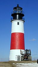
Sankaty Head Light lighthouse
-
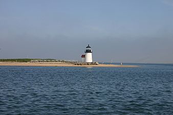
Brant Point Light in Nantucket Harbor
-
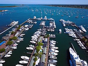
Nantucket Boat Basin


Past Transportation Accidents
The waters around Nantucket have been the site of several notable transportation accidents:
- On May 15, 1934, the large ship RMS Olympic (a sister ship to the RMS Titanic) crashed into and sank the Nantucket Lightship LV-117 in thick fog. This happened about 45 miles (72 km) south of Nantucket Island. Only four of the 11 crew members survived.
- On July 25, 1956, the Italian ship SS Andrea Doria collided with the MS Stockholm in heavy fog. This accident occurred 45 miles (72 km) south of Nantucket and resulted in the deaths of 51 people.
- On August 15, 1958, Northeast Airlines Flight 258 crashed while trying to land at Nantucket Memorial Airport. 25 out of 34 passengers and crew members died.
- On December 15, 1976, the oil tanker Argo Merchant ran aground 29 miles (47 km) southeast of Nantucket. Six days later, the ship broke apart, causing a large oil spill.
- On October 31, 1999, EgyptAir Flight 990, flying from New York City to Cairo, crashed about 60 miles (97 km) south of Nantucket. All 217 people on board died.
Historic Places to Visit
Several places on Nantucket are listed on the National Register of Historic Places. This means they are important historical sites.
- Nantucket Historic District: This area is a National Historic Landmark District (added in 1966). It was expanded in 1975 to include the entire island.
- Brant Point Light Station: A lighthouse at Brant Point (added in 1987).
- Jethro Coffin House: A National Historic Landmark on Sunset Hill Road (added in 1968).
- Sankaty Head Light: A lighthouse (added in 1987).
Famous People from Nantucket
Many well-known people own homes or visit Nantucket regularly. Here are some who have lived on the island:
- Askamaboo: A Wampanoag leader from the 1600s.
- Donick Cary: A writer and producer.
- James A. Folger: The person who started the Folgers coffee company.
- Peter Folger: An early missionary.
- Anna Gardner: An abolitionist (someone against slavery), poet, and teacher.
- Elin Hilderbrand: A popular author.
- Maria Mitchell: A famous astronomer.
- Rowland Hussey Macy: The founder of Macy's department store.
- Lucretia Coffin Mott: A minister, abolitionist, and supporter of women's rights.
- Nathaniel Philbrick: An author.
- Meghan Trainor: A well-known singer and songwriter.
Sister Cities
Nantucket has one sister city:
 - Beaune, Côte d’Or, France
Images for kids
-

1870s street scene on Nantucket

See also
 In Spanish: Nantucket para niños
