
Mount Tom (Massachusetts) facts for kids
Quick facts for kids Mount Tom |
|
|---|---|

Mount Tom's east face and the Connecticut River, from the Joseph Muller Bridge
|
|
| Highest point | |
| Elevation | 1,202 ft (366 m) |
| Prominence | 961 ft (293 m) |
| Naming | |
| Etymology | Named for surveyor Rowland Thomas |
| Geography | |
| Location | Holyoke and Easthampton, Massachusetts, U.S. |
| Parent range | Mount Tom Range / Metacomet Ridge |
| Geology | |
| Age of rock | 200 Ma |
| Mountain type | Fault-block; igneous |
| Climbing | |
| Easiest route | Metacomet-Monadnock Trail |
Mount Tom is a tall, rugged mountain in Massachusetts, USA. It stands about 1,202 feet (366 m) high. This mountain is known for its steep cliffs and amazing views of the Connecticut River Valley. It's the highest point in the Mount Tom Range and the tallest traprock peak along the 100-mile (160 km) long Metacomet Ridge.
Mount Tom is a popular place for outdoor activities. You can see its dramatic cliffs from far away. The mountain is also special because it has rare plants and unique tiny ecosystems called microclimates. It's located in the towns of Easthampton and Holyoke. A long hiking path called the 110-mile (180 km) Metacomet-Monadnock Trail crosses over it. Mount Tom is also home to the transmitters for several TV and radio stations.
Contents
History of Mount Tom
How Mount Tom Got Its Name
People say that Mount Tom was named after a surveyor named Rowland Thomas. He worked for the settlement of Springfield, Massachusetts in the 1660s. The story goes that Thomas named this mountain after himself. At the same time, another surveyor, Elizur Holyoke, was working on the other side of the Connecticut River. He supposedly gave his name to Mount Holyoke.
Mountain Park and the Summit House
In 1897, the Holyoke Street Railway Company started building the Mount Tom Railroad. They also created "Mountain Park" on the east side of the mountain. This was first a "trolley park," which was like an early amusement park you could reach by trolley car. Later, it became a full amusement park. Mountain Park was very popular for many years. However, it closed in 1988 because bigger amusement parks started to attract more visitors.
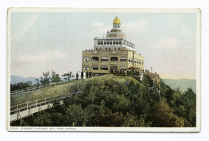
The Mount Tom Summit House was also built in 1897 on the cliffs of Mount Tom. It was a grand building where visitors could relax and enjoy the views. Sadly, it burned down three years later in 1900. A new Summit House was built by 1902. This property became the first part of the Mount Tom State Reservation. But this second house also burned down in 1929. After that, a much smaller, simpler building was put up, but it wasn't very popular and was taken down in 1939. You can still see the ruins of the old summit house foundations on the mountain today.
In 1933, a group called the Civilian Conservation Corps (CCC) helped build structures and roads in the park. Their work is still visible today.
The B-17 Plane Crash
On July 9, 1946, a US Army Air Force B-17G Flying Fortress plane crashed into the northern side of Mount Tom. All 25 people on board died instantly. Many of them were soldiers returning from duty in Europe or Greenland after World War II.
Today, tiny pieces of the plane can still be found on the mountainside. There's a special memorial site at the crash location, which was dedicated on July 6, 1996. It is lit up all the time to honor those who lost their lives.


Geology and Ecology

How Mount Tom Was Formed
Mount Tom is made of a type of rock called basalt, also known as traprock. This rock formed from volcanic activity. The mountain was created about 200 million years ago, near the end of the Triassic Period. This was when the North American continent began to split apart from Africa and Eurasia.
During this time, hot Lava flowed up from deep cracks in the Earth. This lava cooled and hardened into thick layers of rock. Later, faults (cracks in the Earth's crust) and earthquakes caused these rock layers to tilt. This tilting created the dramatic cliffs and ridges we see on Mount Tom today.
Unique Ecosystems
Mount Tom has a mix of different environments. Some slopes are hot and dry, while ravines are cool and moist. There are also rocky ledges made of basalt. These different conditions create special "microclimate ecosystems." A microclimate is like a tiny climate within a larger area. These unique microclimates support plants and animals that are rare in other parts of Massachusetts.
Recreation
Mount Tom is a great place for outdoor fun!
- Hiking: The 110-mile (180 km) Metacomet-Monadnock Trail crosses the summit. There are also many shorter hiking trails.
- Biking and Running: A park road goes beneath the western cliffs. It's popular for bicycling, running, and mountain biking.
- Winter Sports: In winter, people enjoy cross-country skiing and ski touring on the mountain.
- Geocaching: This is a fun outdoor treasure hunt using GPS devices, and it's popular on Mount Tom.
- Bird Watching: The mountain is a famous spot to watch raptor (birds of prey) migrations. There's an observation tower on nearby Goat Peak just for this purpose.
Mount Tom is also registered for Amateur Radio enthusiasts as SOTA W1/MB-006.
Conservation Efforts

Most of Mount Tom is protected land. It's part of the Mount Tom State Reservation. Other parts are protected through conservation agreements or as land that helps protect water sources.
Mount Tom was once home to the Mount Tom Ski Area, which operated from 1962 to 1998. Even though the ski area is closed, people still use the slopes for backcountry skiing. The land where the ski area used to be has been saved by several non-profit groups and the Commonwealth of Massachusetts. These groups do not plan to reopen the ski area.
|
