Mount Tom Range facts for kids
Quick facts for kids Mount Tom Range |
|
|---|---|
| Metacomet Ridge | |

The range's peaks depicted in an 1865 painting by Thomas Charles Farrer (1839–1891), oil on canvas
|
|
| Highest point | |
| Peak | Mount Tom |
| Elevation | 1,202 ft (366 m) |
| Dimensions | |
| Length | 4.5 mi (7.2 km) east-west |
| Geography | |

Mount Tom Range
Location in Massachusetts
|
|
| Country | United States |
| Geology | |
| Age of rock | Triassic and Jurassic |
| Type of rock | fault-block, igneous and sedimentary |
The Mount Tom Range is a group of mountains in the Connecticut River Valley in Massachusetts. These mountains are made of a special kind of rock called traprock. The Mount Tom Range is part of the larger Metacomet Ridge. This ridge stretches from Long Island Sound in Connecticut all the way north into Massachusetts, almost reaching Vermont.
People love to visit the Mount Tom Range for outdoor fun. It's famous for its tall cliffs that face west. The area is also known for its beautiful and wild scenery. The range has special weather areas called microclimates. These areas allow rare plants to grow. You can also find important historical places here. One example is the old ruins of the Eyrie House on Mount Nonotuck, which dates back to the 1700s.
Contents
Geography of the Mount Tom Range
The Mount Tom Range rises sharply from the Connecticut River Valley. It goes up between 500 and 1,100 feet. The range is about 4.5 miles (7 km) long. At its widest, it is about 1.5 miles (2.4 km) across. Even though it's not huge, the rugged land makes it feel much bigger.

| Main Peaks of the Range | |||
|---|---|---|---|
| Name | Height above sea level | What makes it special | |
| ft | m | ||
| Mount Tom (summit) | 1,202 | 366 | This is the highest point of the range. It has cliffs up to 400 feet tall. |
| Deadtop | 1,115 | 340 | |
| Whiting Peak | 1,014 | 309 | |
| Goat Peak | 822 | 251 | This peak has a special platform to watch raptors (birds of prey). |
| Dry Knoll | 835 | 255 | |
| Mount Nonotuck | 827 | 252 | Here you can find the ruins of the historic Eyrie House. |
| Little Mount Tom | 631 | 192 | A wooded hill recently protected by The Trustees of Reservations. |

Sometimes, the whole range is just called "Mount Tom." The range runs from south to north. It is located in the towns of Easthampton and Holyoke.
The Metacomet Ridge continues south from the Mount Tom Range. It becomes East Mountain. To the east, across the Connecticut River, it becomes the Holyoke Range. To the north, the Metacomet Ridge is broken. The Mount Tom Range is separated from the Pocumtuck Ridge by about 9 miles (14 km). The east side of the range drains into the Connecticut River. This river then flows into Long Island Sound. The west side drains into the Manhan River, which also flows into the Connecticut River.
History of the Mount Tom Range

A popular story says that Mount Tom got its name from Rowland Thomas. He was a surveyor for the settlement of Springfield, Massachusetts in the 1660s. Thomas supposedly named the mountain after himself. At the same time, another surveyor, Elizur Holyoke, named Mount Holyoke after himself.
Before the mid-1800s, not much was written about the Mount Tom Range. Native Americans lived in this area for at least 10,000 years. They grew crops like maize, tobacco, beans, and squash in the Connecticut River floodplain. They cleared small parts of the forest by burning them for their farms. They also hunted and fished. They made tools and arrowheads from the basalt rock found in the Metacomet Ridge.
Tensions grew between the local Pocumtuc tribe and the European settlers. Settlers started arriving in the mid-1600s. This led to King Philip's War in 1675. This was a conflict between colonists and Native American tribes led by Metacomet. After the war, more settlers arrived. By the early 1800s, most towns in the region were set up. Most of the land was cleared for farms. Farmers liked the rich soil, which was good for growing tobacco.
Rugged areas like the Mount Tom Range were not good for farming. But they were used for timber. This timber was turned into charcoal. Charcoal was a main fuel for making steel before coal became widely used. Sometimes, fires set to clear land for farms would get out of control. These fires would burn timber in the highlands too.
By the early 1900s, farming moved west. Making charcoal became less profitable. So, much of rural New England became forested again. A study in 2004 suggested that the Metacomet Ridge might have stayed mostly forested. This helped the area keep its many different plants and animals.
In the 1800s, more cities and factories appeared in New England. This led to a movement called transcendentalism. Artists like those from the Hudson River School painted landscapes. Famous painters like Frederic Edwin Church and Thomas Cole were part of this. Cole famously painted the Connecticut River from Mount Holyoke in 1836. This movement changed how people saw mountains. They became places for fun and beauty, not just for resources. Hotels, parks, and summer homes were built on the mountains from the 1880s to the early 1900s.
Early Tourism and Conservation Efforts

In 1861, William Street opened a hotel called Eyrie House on Mount Nonotuck. This was after a hotel on Mount Holyoke became popular. The Eyrie House was closer to the Connecticut River, making it easier to reach. This made the Mount Holyoke hotel owners build a rail line and ferry to their mountain. The Eyrie House burned down in 1901. This happened when Street tried to burn two horses on the mountain and lost control of the fire. Only the stone walls and cellar holes remained.
Another hotel, the Mount Tom Hotel, was built on the summit of Mount Tom in 1897. It also burned down three years later. It was rebuilt but burned again in 1929 and was never rebuilt. In 1902, this land became the first part of the Mount Tom State Reservation. In 1933, the Civilian Conservation Corps helped build park structures and roads. Many of these are still there today.
In 1897, the Holyoke Street Railway Company started building "Mountain Park." This was a trolley park and later an amusement park on the east side of the range. The park changed owners several times. It closed in 1988 because bigger amusement parks took away its business. Locals lovingly called it "The Queen of the Mountain."
Both the Holyoke Range and the Mount Tom Range were part of a plan in 1966. The National Park Service wanted to create a "Connecticut River National Recreation Area." This plan never happened. However, many local and national groups have worked to protect these areas. They have bought land to expand state parks. The Commonwealth of Massachusetts created the Connecticut River Greenway State Park. The National Park Service also suggested making the Metacomet-Monadnock Trail a new National Scenic Trail.
Geology and Environment

The Mount Tom Range was formed about 200 million years ago. This was during the late Triassic and early Jurassic periods. The mountains are made of traprock, also known as basalt. Basalt is a dark rock that comes from volcanic eruptions. When the iron in basalt touches air, it turns a rusty brown. This gives the cliffs a reddish look. Basalt often breaks into columns with five or eight sides. This creates a unique "postpile" look.
Huge slopes of broken basalt rock, called talus, are visible below many cliffs. You can see them well below Mount Tom, Whiting Peak, and Deadtop. These slopes are along the Mount Tom State Reservation park road. You can also see them from the Metacomet-Monadnock Trail at the top.
The basalt ridges formed from several huge lava flows. These flows were hundreds of feet deep. They came up through cracks in the Earth's crust. These cracks formed when North America pulled away from Eurasia and Africa. These lava floods happened over 20 million years. Between eruptions, layers of sediment were deposited. These sediments later turned into sedimentary rock.
The layers of basalt and sedimentary rock then faulted and tilted upwards. Over time, erosion wore away the softer sedimentary layers faster than the hard basalt. This left the tilted edges of the basalt layers exposed. This is what created the distinct long ridge and dramatic cliffs we see today. Imagine a layer cake tilted a bit. Then, some of the frosting (the sedimentary layer) is removed between the cake layers.
The Mount Tom Range has a mix of microclimates. These are unusual for New England. The dry, hot upper ridges have oak savannas. These are often covered with chestnut oak trees. They also have different grasses and ferns. Eastern red cedar trees, which like dry places, grow on the edges of the cliffs.
Plant communities on the back slopes are more like the nearby Berkshires plateau. They have plants common to northern hardwood and oak-hickory forest types. Eastern hemlock trees grow in narrow ravines. They block sunlight, making these areas damp and cool. This allows cooler climate plants to grow there. Talus slopes are rich in nutrients. They support many calcium-loving plants that are rare in Massachusetts. Because the traprock ridges create such varied land, they are home to several rare plant and animal species.
The Mount Tom Range is also an important path for raptors during their seasonal migration.
Recreation and Outdoor Activities

There are many miles of trails and some seasonal roads that climb the ridgeline. This includes the 110-mile (180 km) Metacomet-Monadnock Trail. The Berkshire Chapter of the Appalachian Mountain Club maintains this trail. People use the range for picnicking, hiking, and snowshoeing. You can also enjoy bicycling and cross-country skiing on the park roads.
The ridge used to have the Mount Tom Ski Area, but it is now closed. The old ski trails are still used for backcountry skiing. However, there are no lifts working. Recently, paragliding has become popular in the US. The western face of Mount Tom is used as a launch point. Flights can go as far as the Worcester area. There are no camping facilities on the range.
There are several parking lots for trails within the Mount Tom State Reservation. You can reach them from Route 5 in Holyoke and East Street in Easthampton. Only the easternmost lot is open during the off-season. You can also find parking off Route 5 and at the south side of Whiting Street Reservoir. Another parking spot is off Route 141 in Holyoke, near the Log Cabin Restaurant. During the on-season, there is a fee to drive into the Mount Tom State Reservation. Parking for the Metacomet-Monadnock Trail is off Route 141. It is located in the gap between East Mountain and Mount Tom. There is also parking at the base of Mount Nonotuck on Underwood Street in Easthampton. This is where the Metacomet-Monadnock Trail comes down from the top of the range.
Conservation Efforts
Much of the Mount Tom Range is protected as part of Massachusetts's Mount Tom State Reservation. Other parts are managed by non-profit conservation groups, like The Trustees of Reservations. In 2000, the National Park Service studied the Mount Tom Range. They considered it for a new National Scenic Trail. This trail is now called the New England National Scenic Trail. It would include the Metacomet-Monadnock Trail in Massachusetts. It would also include the Mattabesett Trail and Metacomet Trail in Connecticut.
In 2002, several conservation groups and the Commonwealth of Massachusetts worked together. They successfully protected a large piece of land on the east side of the range. This land used to be part of a downhill ski area that closed in 1998. An existing rock quarry on the property was also secured. These efforts happened because people were upset. The former landowner wanted to sell the land to a rock and gravel company. This company wanted to expand the quarry.
Other groups that help protect the Mount Tom Range and its beautiful views include The Kestrel Trust, The Valley Land Fund, and the Pascommuck Conservation Trust.
Images for kids
-
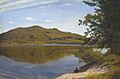
The range's peaks depicted in an 1865 painting by Thomas Charles Farrer (1839–1891), oil on canvas
-
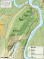
Topographic map of the Mount Tom Range
-
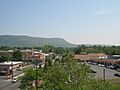
Mount Tom Range from Easthampton
-
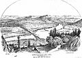
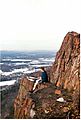
View from Mount Nonotuck.
From "History of the Connecticut Valley, Massachusetts Vol 1" 1879, by Louis Everts -
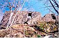
Ruins of Eyrie House, 2003
-

The Mount Tom Summit House. Postcard dated 1898–1900.
-
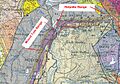
Bedrock geology. Purple=basalt; surrounding brown & blue-grey=sedimentary rock
-