Connecticut River Greenway State Park facts for kids
Quick facts for kids Connecticut River Greenway State Park |
|
|---|---|

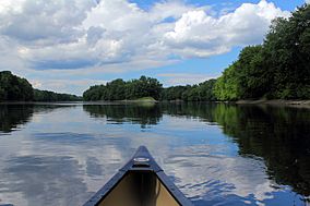
Paddling north on the Connecticut River in Sunderland
|
|
| Location | Franklin, Hampden, Hampshire, Massachusetts, United States |
| Area | 1,048 acres (4.24 km2) |
| Established | Unspecified |
| Governing body | Massachusetts Department of Conservation and Recreation |
| Website | Connecticut River Greenway State Park |
The Connecticut River Greenway State Park is a special place in western Massachusetts. It's a protected area along the Connecticut River in the Pioneer Valley. This park isn't just one big piece of land. It's made up of many different areas. These include open spaces, parks, and spots with amazing views.
The park also protects important homes for animals and plants. It gives people ways to get to the river. This park works with other protected lands. These include farms, town lands, and wildlife refuges.
Contents
History of the Park
How the Park Grew Over Time
The Department of Conservation and Recreation (DCR) helps manage this park. They started buying land for the park around 1986. They kept adding new pieces for about 20 years. Some areas, like Mount Tom State Reservation, were already protected.
Terry Blunt's Important Role
A person named Terry Blunt (1941-2010) was key to creating the park. He worked for the DCR. He helped bring many people and groups together. His hard work protected this very special place.
Fun Things to Do at the Park
Exploring the River and Shoreline
The park has about 12 miles of protected river shoreline. This means there are many ways to enjoy the water. You can go boating, canoeing, or fishing. It's also a great spot for a picnic.
Where to Access the River
The DCR has marked several places where you can get to the river. Here are some of them:
- Pauchaug Brook, Northfield: This spot is one mile north of Northfield Center. It has a paved parking area. There's a ramp for canoes and motorboats.
- Barton Cove, Gill: You can find this east of Turners Falls. It has paved parking and a ramp. It's good for motorboats or canoes.
- Sunderland: This access point is on the north side of the Sunderland Bridge. It's good for canoes and fishing. Parking is limited here.
- Hatfield: This spot is one mile north of Hatfield's center. It's best for canoes and small, light boats.
- Elwell Recreation Area, Northampton: This area is near Route 9 and I-91. You can only use canoes and rowing boats here. There's a dock that is easy for wheelchairs to use. Parking is limited.
- Oxbow Ramp, Easthampton: Take I-91 to exit 18, then south on Route 5. This spot has 35 parking spaces. It has a paved ramp. It's often used by powerful boats and larger fishing boats.
- South Hadley/Chicopee Boat Access: This is on James Street, past the Holyoke dam. It has a gravel ramp for small fishing boats. It's very popular during shad fishing season.
- Chicopee Boat Access, Chicopee: This spot is good for many types of boats. It's easy to get canoes and rowing shells into the water here.
 | Emma Amos |
 | Edward Mitchell Bannister |
 | Larry D. Alexander |
 | Ernie Barnes |


