
Mount Nonotuck facts for kids
Quick facts for kids Mount Nonotuck |
|
|---|---|

The northern portion of the Mount Tom Range, with Mount Nonotuck visible to the right
|
|
| Highest point | |
| Elevation | 827 ft (252 m) |
| Geography | |
| Location | Holyoke, Massachusetts |
| Parent range | Mount Tom Range / Metacomet Ridge |
| Geology | |
| Age of rock | 200 Ma |
| Mountain type | fault-block igneous |
| Climbing | |
| Easiest route | Auto road |
Mount Nonotuck is a mountain in Holyoke, Massachusetts. It stands about 827 feet (252 meters) tall. This mountain is the northernmost peak of the Mount Tom Range. It's also part of a much longer chain of mountains called the Metacomet Ridge. This ridge stretches from Long Island Sound all the way to near the Vermont border.
Mount Nonotuck looks rugged and beautiful. It rises sharply about 700 feet (213 meters) from the Connecticut River Valley below. A long hiking path, the Metacomet-Monadnock Trail, crosses over Mount Nonotuck. This trail is about 110 miles (177 kilometers) long. There's also a road that goes up the mountain. It's closed to cars right now, but hikers can still use it. In winter, people often use this road for cross-country skiing.
A Look Back: Mount Nonotuck's History

In 1861, a man named William Street opened a hotel on top of Mount Nonotuck. He called it Eyrie House. This happened after another successful hotel opened on Mount Holyoke, a mountain across the river. Eyrie House was easier to reach because it was closer to the Connecticut River.
Because of this, the owners of the Mount Holyoke hotel built a special rail line. This helped their guests get from the river to their hotel more easily. Sadly, Eyrie House burned down in 1901. Mr. Street was trying to cremate two horses on the mountain. He lost control of the fire, and the hotel was destroyed.
Today, only the stone walls and cellar holes of the old hotel remain. The area where the hotel once stood is now part of the Mount Tom State Reservation. This park is managed by the state of Massachusetts. From the ruins, you can see the Connecticut River Oxbow. This is a curved lake that used to be part of the Connecticut River. A famous painter named Thomas Cole even painted it a long time ago.
How Mount Nonotuck Formed: Geology and Ecosystems
Mount Nonotuck is made of a type of rock called basalt. This rock is also known as traprock. It's a volcanic rock, meaning it came from volcanoes. The mountain formed about 200 million years ago. This was near the end of the Triassic Period. At that time, the continents of North America, Africa, and Eurasia were slowly pulling apart.
As the continents separated, hot Lava flowed up from deep underground. This lava cooled and hardened into thick layers of rock. Later, earthquakes and cracks in the Earth's crust, called faults, tilted these rock layers. This created the steep cliffs and ridges you see on Mount Nonotuck today.
The mountain has many different small environments, called microclimates. For example, some slopes are hot and dry. Other areas, like ravines, are cool and moist. There are also rocky ledges made of basalt talus, which is broken rock. These different conditions create special places for plants and animals. Because of this, Mount Nonotuck is home to some plant and animal species that are rare in other parts of Massachusetts. To learn more about the geology and living things of Mount Nonotuck, you can look up information about the Metacomet Ridge.
Images for kids
-
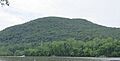
The northern portion of the Mount Tom Range, with Mount Nonotuck visible to the right
-
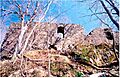
Eyrie House ruins, 2003
