
Snake Mountain (Vermont) facts for kids
Quick facts for kids Snake Mountain |
|
|---|---|
| Grand View Mountain | |

Snake Mountain ridgeline
|
|
| Highest point | |
| Elevation | 1,287 ft (392 m) NGVD 29 |
| Prominence | 993 ft (303 m) |
| Listing | Mountains of Vermont |
| Geography | |

Snake Mountain
Location in Vermont
|
|
| Country | United States |
| State | Vermont |
| County | Addison |
| Town | Addison / Weybridge |
| Parent range | Taconic Mountains |
| Topo map | USGS Port Henry |
| Geology | |
| Age of rock | Taconic orogeny, 440 million years |
| Mountain type | thrust fault |
Snake Mountain, also known as Grand View Mountain, is a special mountain in Vermont, USA. It stands alone in the landscape. This mountain is located between the towns of Addison and Weybridge in Addison County.
Most of Snake Mountain, including its highest point, is part of a protected area. This area is called the Snake Mountain Wildlife Management Area (WMA). It covers about 1,215-acre (492 ha) and is managed by the Vermont Fish & Wildlife Department. Next to the WMA is the 81-acre (33 ha) Wilmarth Woods Natural Area, which is protected by The Nature Conservancy.
Snake Mountain is one of several hills that stretch into the Champlain Valley. These hills come from the larger Taconic Mountains in southwestern Vermont. If you look at the mountain from the west, you can see its tall, steep cliffs. They rise sharply from the valley, making it easy to spot. From the top of the mountain, you get an amazing view. You can see Lake Champlain and the Adirondack Mountains to the west. People sometimes call this view "Grand View."
Contents
Mountain History
How Snake Mountain Formed
Over 400 million years ago, huge movements in the Earth's crust happened. This caused older rocks to slide on top of newer ones. This event is part of what geologists call the Taconic orogeny. Over hundreds of millions of years, wind and rain slowly carved out the land. This is how Snake Mountain was shaped into what we see today.
Around 13,000 years ago, the mountain was a small island. It stood in the deep waters of a giant ancient lake. This lake was called glacial Lake Vermont. It was much bigger than today's Lake Champlain. Eventually, the water levels dropped. This revealed Snake Mountain and other hills in the Champlain Valley.
The Grand View Hotel
Snake Mountain was once home to a famous hotel. It was called the Grand View Hotel. A man named Jonas N. Smith built it around 1870. He also built a tall observation tower and a road for carriages to reach the top. Smith thought the name "Snake Mountain" might scare people away. So, he changed the mountain's name to Grand View Mountain.
The hotel opened in 1874. It quickly became a very popular place for summer trips. People loved to visit and enjoy the views.
What Happened to the Hotel?
The Grand View Hotel closed its doors in 1925. Bad weather later destroyed parts of the mountain's attractions. The carriage road was washed away in a big flood in 1927. The observation tower was destroyed by a hurricane in 1938. The hotel itself eventually burned down. The state of Vermont bought the land at the summit in 1988.
Today, the old carriage road is a popular path for hikers. Many people think the concrete pad at the summit was part of the hotel. But it was actually the foundation for a house. A young man started to build it before he passed away overseas.
Hiking Trails
There are several hiking trails that cross Snake Mountain. The main starting point for hikers is on the west side of the mountain. You can find it where Wilmarth Road and Mountain Road meet in the town of Addison.
From this spot, a 1.8-mile (2.9 km) trail leads to the summit. This path goes through Wilmarth Woods. It then follows the old carriage road all the way to the top. There's another path that goes along the mountain's ridge. This ridge trail is just west of the carriage road. However, this ridge trail might be closed from March 15 to August 1. This closure helps protect nesting peregrine falcons.
These two paths together form a 4.1-mile (6.6 km) loop trail. You can hike up to the summit and then back down. There is also a second loop trail. This one combines the carriage road with another trail. This second trail goes through the Snake Mountain Wildlife Management Area. It cuts across the eastern side of the mountain.
Images for kids
-
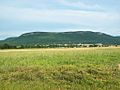
The west side of Snake Mountain from Vermont Route 17
-
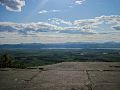
Lake Champlain and the Adirondacks from the summit of Snake Mountain
-
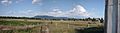
A full panorama of Snake Mountain


