Pembroke, New York facts for kids
Quick facts for kids
Pembroke, New York
|
|
|---|---|

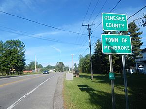
Route 5 entering the town of Pembroke
|
|

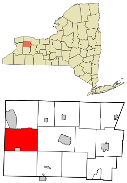
Location in Genesee County and the state of New York
|
|
| Country | United States |
| State | New York |
| County | Genesee |
| Government | |
| • Type | Town Council |
| Area | |
| • Total | 41.72 sq mi (108.05 km2) |
| • Land | 41.63 sq mi (107.81 km2) |
| • Water | 0.09 sq mi (0.23 km2) |
| Elevation | 853 ft (260 m) |
| Population
(2010)
|
|
| • Total | 4,292 |
| • Estimate
(2016)
|
4,240 |
| • Density | 101.86/sq mi (39.33/km2) |
| Time zone | UTC-5 (Eastern (EST)) |
| • Summer (DST) | UTC-4 (EDT) |
| ZIP code |
14036
|
| Area code(s) | 585 |
| FIPS code | 36-037-57078 |
| GNIS feature ID | 0979350 |
Pembroke is a small town located in Genesee County, in Western New York, United States. In 2010, about 4,292 people lived here. The town got its name from a place in west Wales. Pembroke is found on the western edge of Genesee County, just west of Batavia.
Contents
Discover Pembroke's History
Pembroke was first settled in 1804. A person named David Goss was one of the very first settlers.
The town of Pembroke was officially created in 1812. It was formed from a part of the nearby town of Batavia.
Explore Pembroke's Geography
Pembroke covers a total area of about 41.7 square miles (108.05 square kilometers). Most of this area is land. Only a tiny part, about 0.02%, is water.
The New York State Thruway (Interstate 90) runs right through Pembroke. Also, New York State Route 5 crosses paths with New York State Route 77 in the town.
Two important waterways, Tonawanda Creek and its smaller stream, Murder Creek, flow through Pembroke. The western border of the town is also the border of Erie County.
Neighboring Towns and Cities
Pembroke shares its borders with several other towns:
- To the west, in Erie County, are the Town of Alden and the Town of Newstead.
- To the north, you'll find the Town of Alabama.
- The Town of Oakfield is to the northeast.
- To the east is the Town of Batavia.
- The Town of Alexander is to the southeast.
- To the south is the Town of Darien.
- The Village of Corfu is located in the southern part of Pembroke, next to the Town of Darien.
Important Roads in Pembroke
Several major highways help people travel through Pembroke:

 The Interstate 90, also known as the New York State Thruway, goes from east to west through the town. It connects Newstead to Batavia. There's a special service area on the Thruway for eastbound travelers, named after Pembroke.
 New York State Route 5 (Main St.) is an east-west highway. It runs through the middle of town, connecting Newstead to Batavia.
 New York State Route 33 (Genesee St.) is another east-west highway. It goes from the Darien town line to the Batavia town line.
 New York State Route 77 (Alleghany Rd.) is a north-south highway. It travels through the center of town, from Corfu to Alabama.
Notable Places to Visit
The Western New York National Cemetery is located in Pembroke. This special place is for burying military veterans. The first burials were expected to happen by the end of the 2010s.
Understanding Pembroke's Population
| Historical population | |||
|---|---|---|---|
| Census | Pop. | %± | |
| 1820 | 2,576 | — | |
| 1830 | 3,831 | 48.7% | |
| 1840 | 1,970 | −48.6% | |
| 1850 | 2,279 | 15.7% | |
| 1860 | 2,855 | 25.3% | |
| 1870 | 2,810 | −1.6% | |
| 1880 | 2,845 | 1.2% | |
| 1890 | 2,679 | −5.8% | |
| 1900 | 2,425 | −9.5% | |
| 1910 | 2,301 | −5.1% | |
| 1920 | 2,202 | −4.3% | |
| 1930 | 2,209 | 0.3% | |
| 1940 | 2,391 | 8.2% | |
| 1950 | 2,866 | 19.9% | |
| 1960 | 3,451 | 20.4% | |
| 1970 | 3,959 | 14.7% | |
| 1980 | 4,146 | 4.7% | |
| 1990 | 4,232 | 2.1% | |
| 2000 | 4,530 | 7.0% | |
| 2010 | 4,292 | −5.3% | |
| 2016 (est.) | 4,240 | −1.2% | |
| U.S. Decennial Census | |||
In 2000, Pembroke had 4,530 people living there. About 1,660 households were counted. Many of these households, 61.3%, were married couples living together.
The average household had about 2.73 people. The average family size was 3.16 people. About 27.9% of the population was under 18 years old. The median age in Pembroke was 37 years.
Communities and Locations in Pembroke
Pembroke is made up of several smaller communities and areas:
- Brick House Corners – This is a small hamlet where NY-5 and NY-77 meet. A toll plaza for the New York Thruway is just north of this intersection.
- Cookville – This area is now known for the Pembroke service area on the New York State Thruway. It's in the eastern part of the town.
- Corfu – The village of Corfu is on the southern border of Pembroke. It was first called "Long's Corners." This village is where NY-33 and NY-77 cross.
- East Pembroke – A hamlet located on NY-5. It sits between Pembroke Center and the town of Batavia.
- Indian Falls – This hamlet is named after a beautiful waterfall on Tonawanda Creek. It's also the birthplace of Ely S. Parker, a famous Seneca leader. NY-77 goes through this community.
- North Pembroke – A hamlet found along Tonawanda Creek in the very northeast corner of the town.
- Pembroke – This hamlet is also on NY-5, close to the border with Erie County. It used to be called "Richville." Today, it has houses and some businesses along Main Street. You'll find two small factories here that make dairy products, including Kutters Cheese Factory.
- Pembroke Center – Located on NY-5, between Pembroke and East Pembroke. It's also known as "Frog Hollow." This is where David Goss, the first settler, built the Old White Tavern, which was the first public house in the area.
See also
 In Spanish: Pembroke (Nueva York) para niños
 | May Edward Chinn |
 | Rebecca Cole |
 | Alexa Canady |
 | Dorothy Lavinia Brown |

