
Oatka Creek facts for kids
Quick facts for kids Oatka Creek |
|
|---|---|

Oatka Creek in Wheatland
|
|

Genesee River map showing Oatka on upper left
|
|
| Other name(s) | Allan's Creek |
| Country | United States |
| State | New York |
| Region | Western New York |
| Counties | Wyoming, Genesee, Monroe |
| Towns | Gainesville, Warsaw, Middlebury, Covington, Pavilion, Stafford, Le Roy, Wheatland |
| Physical characteristics | |
| Main source | Near Gainesville-Warsaw town line 1,380 ft (420 m) 42°41′42″N 78°5′38″W / 42.69500°N 78.09389°W |
| River mouth | Genesee River 1 mi (1.6 km) east of Scottsville 500 ft (150 m) 43°1′26″N 77°43′28″W / 43.02389°N 77.72444°W |
| Length | 58 mi (93 km) |
| Discharge (location 2) |
|
| Basin features | |
| Basin size | 215 sq mi (560 km2) |
| Tributaries |
|
Oatka Creek is a long stream in Western New York. It's the third longest tributary of the Genesee River. The creek flows for 58 miles (93 km) from southern Wyoming County. It ends in the Genesee River near Scottsville.
The name "Oatka" comes from the Seneca language. It means "leaving the highlands" or "approaching an opening." The creek's path was shaped by the last Ice Age. Glaciers created a landscape where streams could flow and carve valleys. The Oatka carved a deep valley, known as the Oatka Valley.
Long ago, Native Americans of the Seneca nation lived along the creek. They built small villages where there were clearings in the forest. Later, after the American Revolutionary War, settlers came to the valley. The rich soil here was perfect for farming.
For a while, the creek was called Allan's Creek. This was after Ebenezer "Indian" Allan, one of the first settlers. The creek's flowing water helped early settlers. It powered mills and helped towns grow. Today, Oatka Creek is still important. People use it for water supply and fun activities like fishing. It's especially known for trout fishing. Fish are released into the creek from a very old fish hatchery nearby.
Contents
The Creek's Journey
Oatka Creek starts in Gainesville, Wyoming County. Many small streams join together to form the main creek. These streams begin high up, almost 1,600 feet (490 m) above sea level. The creek flows south at first, then turns northwest. It follows the Norfolk Southern railroad tracks.
Near the hamlet of Rock Glen, the creek crosses New York State Route 19. This road will stay close to the creek for most of its journey. The creek then goes through a narrow gorge. This gorge is what gave the creek its name. It then enters the Oatka Valley, which it follows for the rest of its way. By this point, it has dropped 280 feet (85 m) in elevation.
The creek continues northwest, then north, staying near Route 19. It flows into Warsaw, the county seat. Here, it goes under Route 19 again and then U.S. Route 20A. North of Warsaw, the valley gets wider and flatter. The creek and Route 19 cross paths again in large farm fields.
The valley then turns northeast towards Wyoming. The Oatka Creek flows past Wyoming and through a large wooded area. It also passes through the biggest wetlands along its course. North of there, it crosses Route 19 again. The creek and road enter Genesee County at Pavilion. Here, NY 63 crosses, and there's another important wetlands area.
A few miles north of Pavilion, US 20 crosses the creek. The creek bends west, then north-northeast, returning close to Route 19. It enters the village of Le Roy. Here, it widens into a 26-acre (11 ha) reservoir behind a dam. This dam is just south of NY 5.
North of Le Roy, the creek becomes narrower again. It flows towards Buttermilk Falls. This is where the creek can sometimes flow underground during warm, dry weather. After going over the 60-foot (18 m) falls, it turns east. This part of the creek is called the lower Oatka. It flows through wooded areas and enters Monroe County near Mumford.
After Mumford, NY 383 and the CSX rail line run alongside the creek. The creek then reaches Oatka Creek Park. This is a large area of former farmland. Beyond the park, it flows through more farmland. It passes south of Scottsville, where NY 251 crosses it. About a mile further, Oatka Creek flows into the Genesee River.
The Oatka Creek Watershed
A watershed is an area of land where all the water drains into a single river or stream. The Oatka Creek watershed is quite narrow. It doesn't stretch far from the Oatka Valley itself. Most of the towns of Warsaw, Pavilion, and Le Roy are within this watershed. Large parts of Covington, Gainesville, Middlebury, and Wheatland are also included.
In Livingston County, only Caledonia has land in the watershed. This includes most of the village of Caledonia. Other towns like Perry, Orangeville, and Bethany also have parts of their land draining into the Oatka.
There are five villages partly or fully in the watershed. These are Warsaw, Wyoming, Le Roy, Scottsville, and Caledonia. These are the main areas where people live and work. Most of the watershed (73%) is used for farming. Forests cover another 21%. The rest is mostly homes and businesses.
The highest point in the watershed is 1,990 feet (610 m) in Orangeville. The lowest point is the creek's mouth, at 525 feet (160 m). Including the Oatka itself, there are 425 miles (684 km) of streams in the watershed. There are not many large lakes. The biggest is Lake Le Roy, which used to be the main water supply for Le Roy village. The only protected natural area is the Carlton Hill Wildlife Management Area.
Water Quality and Protection
The United States Geological Survey measures the creek's water flow at two spots. One is near the mouth at Garbutt, and the other is at Warsaw. The village of Warsaw uses the creek for its water supply. They clean the water before people drink it. Other places, like Le Roy, also release treated wastewater into the creek.
Scientists have studied the water quality in the lower part of the creek. Most chemicals are at normal levels. There are slightly higher levels of sulfates. This is because of natural minerals like gypsum and dolomite in the rocks. Sometimes, after heavy rain, certain bacteria levels can be higher.
Overall, the water quality is good. The state's Department of Environmental Conservation (DEC) watches over the creek. They classify parts of the creek as "threatened" or "stressed." This means they are keeping an eye on it to prevent future problems.
In 1999, a group called the Oatka Creek Watershed Committee was formed. They work to protect the creek and its watershed. They study the creek and create plans to keep its water clean.
Wildlife in Oatka Creek
Scientists don't have a full list of all the plants and fish in the creek. But they have found some rare, threatened, or endangered species. To protect these special creatures, their exact locations are kept private.
More is known about the tiny creatures that live on the creek bed. These are mostly young insects that will grow up to fly. Many of these insects, like caddisflies and stoneflies, cannot live in polluted water. So, finding them means the water quality is good. A study in 1989-90 found these insects, but in smaller numbers than expected. This suggests the creek is "slightly impacted" by pollution.

These insects are food for different kinds of trout. The lower part of Oatka Creek is famous for brown trout fishing. Some brook trout also live there. The state fish hatchery near Caledonia releases trout into the creek every year. There are also wild trout living in some parts of the creek. Other fish like bass, walleye, and northern pike can be found closer to the Genesee River.
How Oatka Creek Was Formed
The story of Oatka Creek began about 12,000 years ago. This was when the glaciers from the last Ice Age melted away. They left behind a hilly landscape with dips and hollows. Rain and melted ice filled these areas. Over time, these small bodies of water joined together to form Oatka Creek. The creek then slowly carved out the Oatka Valley. Rich soil from the higher lands settled in the valley, and forests grew.
A Look Back at Oatka Creek's History
The Native Americans who became the Seneca nation were the first people to live along the Oatka Creek. They built small villages in the forest clearings. They were also the first to farm the fertile land in the valley. The trails they used to connect their villages later became some of today's roads. The Senecas were part of the Iroquois Confederation. The Oatka Creek was at the very western edge of their lands. This earned them the name "Keepers of the Western Door."
In 1779, during the American Revolutionary War, a group of soldiers called the Sullivan Expedition came to Western New York. They were there to deal with Senecas who supported the British. Many of these soldiers were farmers from New England. They saw how good the land in the Oatka watershed was. After the war, they wanted the area to be opened for settlement. In 1797, a treaty was signed that allowed settlers to move in.
The first settler along the Oatka was Ebenezer "Indian" Allan in 1786. He settled near where the creek meets the Genesee River. For many years, the creek was known as Allan's Creek. Other settlers soon followed. The village of Scottsville grew from these early settlements. In the 1790s, settlement moved upstream to Le Roy. This was where the creek crossed an old Indian trail, which is now New York State Route 5. More settlers quickly arrived in the early 1800s.
Changes to the River

The biggest change humans have made to Oatka Creek is the dam in Le Roy. This dam creates a 25-acre (10 ha) lake in the middle of the village. In the 1800s, other small dams were built for mills. But these have since been removed or are no longer used. There are no power plants or large flood control projects on the creek.
Many bridges cross the creek. There are 32 bridges built between 1915 and 2003. The oldest one is Union Street in Wheatland. The newest is the NY 251 bridge in Scottsville. Seven bridges carry NY 19 over the creek. The longest bridge is 227-foot (69 m) long. It crosses the lake created by the Le Roy dam. The shortest is 29-foot (8.8 m) long, south of Rock Glen.
What Oatka Creek Means for the Area
In the past, the creek directly helped the local economy. Mills along the creek used its water power. Today, the creek's main economic value comes from being a water supply. It also helps with wastewater treatment for villages like Le Roy and Warsaw.
The narrow Oatka Valley was a good path for transportation. The road that became Route 19 was built here. Later, a railroad was built next to it. This railroad is now run by Norfolk Southern. Where the creek crossed major east-west roads, towns like Le Roy and Warsaw grew.
Fun Activities on Oatka Creek
Oatka Creek is a beautiful place for fun and relaxation. People enjoy hiking, boating, and especially fishing. There are three different fishing areas along the creek.
The upper part of the creek, above Warsaw, is stocked with about 1,850 young brown trout each spring. This adds to the wild trout already living there. Many people fish here. The biggest trout caught in this area was 16 inches (410 mm) long. It's easy for the public to access this part of the creek. There are several bridges and railroad tracks that allow access.
From Warsaw to Le Roy, the creek gets warmer. This area is good for different kinds of fish. You can find bass, pike, sunfish, crappies, and bullhead. There are also public lands and bridges that offer access for fishing.
The lower Oatka is very popular with fly fishermen. Cold groundwater from the Blue Hole and falls cools the creek again. This part of the creek has many stocked and wild brown trout. About 11,200 young trout are added each year. These fish come from the state fish hatchery near Caledonia. This hatchery was started in 1864 and is the oldest in the Western Hemisphere. It was the first place to introduce brown trout to American waters.
It's easy to access this part of the creek. The 1.7-mile (2.7 km) section in Oatka Creek Park is very popular. Here, special rules mean you can only do no-kill fishing with artificial lures all year. Similar rules apply downstream of the park during certain months. Anglers can also access the creek from a park in Scottsville and from bridges. The DEC has also made agreements for public fishing access along some parts of the creek. This means anglers can use the land next to the river to reach the water.
Tributaries
- Relyea Creek
- Stony Creek
- Pearl Creek
- White Creek
- Mud Creek
- Spring Creek
Images for kids
-
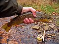
A brown trout taken from the Oatka
-
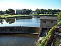
Dam and reservoir at Le Roy
