Wheatland, New York facts for kids
Quick facts for kids
Wheatland
|
|
|---|---|

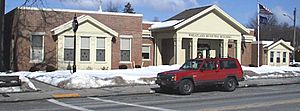
Wheatland town office building
|
|

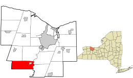
Location in Monroe County and the state of New York.
|
|

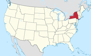
Location of New York in the United States
|
|
| Country | United States |
| State | New York |
| County | Monroe |
| Established | February 23, 1821 |
| Area | |
| • Total | 30.67 sq mi (79.44 km2) |
| • Land | 30.41 sq mi (78.76 km2) |
| • Water | 0.26 sq mi (0.68 km2) |
| Elevation | 605 ft (184 m) |
| Population
(2020)
|
|
| • Total | 4,897 |
| • Density | 159.67/sq mi (61.644/km2) |
| Time zone | UTC-5 (EST) |
| • Summer (DST) | UTC-4 (EDT) |
| ZIP code |
14546
|
| Area code(s) | 585 |
| FIPS code | 36-055-81402 |
| Website | http://www.townofwheatland.org/ |
Wheatland is a small town in Monroe County, New York, United States. In 2020, about 4,897 people lived there. The town is famous for being home to the Genesee Country Village and Museum, which is a living history museum.
Contents
Geography and Land
The town of Wheatland is in the southwest part of Monroe County, New York. It covers about 30.7 square miles (79.44 square kilometers). Most of this area is land, with a small amount of water. The land has gentle rolling hills and flat areas near the Genesee River. The soil is very good for farming.
Wheatland shares its borders with other towns. To the north are Riga and Chili. To the east, it's bordered by the Genesee River and the towns of Henrietta and Rush. To the south and west, it borders Livingston County.
Oatka Creek is the most important waterway in Wheatland. It flows into the Genesee River and has played a big part in the town's history. The New York State Thruway (a major highway) passes just north of Wheatland, through the town of Chili.
People and Population
| Historical population | |||
|---|---|---|---|
| Census | Pop. | %± | |
| 1830 | 2,239 | — | |
| 1840 | 2,871 | 28.2% | |
| 1850 | 2,916 | 1.6% | |
| 1860 | 2,560 | −12.2% | |
| 1870 | 2,565 | 0.2% | |
| 1880 | 2,599 | 1.3% | |
| 1890 | 2,400 | −7.7% | |
| 1900 | 2,071 | −13.7% | |
| 1910 | 2,453 | 18.4% | |
| 1920 | 2,076 | −15.4% | |
| 1930 | 2,364 | 13.9% | |
| 1940 | 2,323 | −1.7% | |
| 1950 | 2,502 | 7.7% | |
| 1960 | 3,711 | 48.3% | |
| 1970 | 4,265 | 14.9% | |
| 1980 | 4,897 | 14.8% | |
| 1990 | 5,093 | 4.0% | |
| 2000 | 5,149 | 1.1% | |
| 2010 | 4,775 | −7.3% | |
| 2020 | 4,897 | 2.6% | |
| U.S. Decennial Census | |||
In 2000, there were 5,149 people living in Wheatland. This number was about 4,897 in 2020. Most people in the town are White (about 93%). There are also African American, Native American, and Asian residents. About 2% of the population is Hispanic or Latino.
There were over 2,000 households in the town. Many of these households (about 58%) were married couples living together. About 33% of households had children under 18 living with them.
The average age of people in Wheatland in 2000 was 37 years old. About 26.5% of the population was under 18. About 11.5% of the people were 65 years old or older.
Education
The public schools in Wheatland are part of the Wheatland-Chili Central School District. This district includes an elementary school, a middle school, and a high school for students.
History of Wheatland
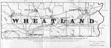
The first people to settle in the area arrived around 1789. The town was officially created on February 23, 1821. It was first called Inverness.
However, on April 3, 1821, the state government changed the town's name to Wheatland. This change was supposedly suggested by John Garbutt, who was from England.
In the early days, growing wheat and making flour were the main ways people made money in the county. The Wheatland area was very important for this business. In 1850, the counties of Monroe and Livingston (where Wheatland is) grew more wheat than any other place in the United States.
Later, as new farming areas opened up in the middle of the United States, the local wheat industry started to slow down. Bad weather in the late 1850s also made things harder for farmers.
Two historic places in Wheatland, the Romanta T. Miller House and Oatka Cemetery, were added to the National Register of Historic Places in 2014. This means they are important places in history.
Public Services
The Scottsville Free Library serves the people in Wheatland. It is located at 28 Main Street and offers books and other resources to the community.
Communities and Places in Wheatland
Here are some of the smaller communities and important locations you can find in the town of Wheatland:
- Belcoda – A small area located north of Mumford.
- Beulah – An area in the northwest corner of the town.
- Garbutt – A small village (called a hamlet) on Route 383. It used to be known as Garbuttsville.
- Mumford – Another hamlet near the southern border of the town, on Route 36. It was first called Mackenzie's Corners, then changed its name to Mumfordville, and finally to Mumford.
- Oatka Creek Park – A county park located near Garbutt, right next to the Oatka Creek.
- Scottsville – This is the only official village in Wheatland. It's in the northeast part of the town on Route 383.
- Wheatland Center – This used to be a hamlet on Route 383, close to the Oatka Creek. It was once called Hall's Corners.
See also
 In Spanish: Wheatland (Nueva York) para niños
 | Janet Taylor Pickett |
 | Synthia Saint James |
 | Howardena Pindell |
 | Faith Ringgold |


