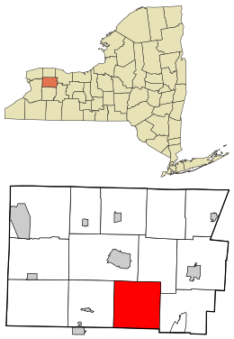
Bethany, New York facts for kids
Quick facts for kids
Bethany, New York
|
|
|---|---|

Location in Genesee County and the state of New York.
|
|
| Country | United States |
| State | New York |
| County | Genesee |
| Government | |
| • Type | Town Council |
| Area | |
| • Total | 36.07 sq mi (93.42 km2) |
| • Land | 36.03 sq mi (93.33 km2) |
| • Water | 0.04 sq mi (0.09 km2) |
| Elevation | 1,181 ft (360 m) |
| Population
(2010)
|
|
| • Total | 1,765 |
| • Estimate
(2016)
|
1,731 |
| • Density | 48.04/sq mi (18.55/km2) |
| Time zone | UTC-5 (Eastern (EST)) |
| • Summer (DST) | UTC-4 (EDT) |
| ZIP Code |
14028
|
| Area code(s) | 585 |
| FIPS code | 36-037-06266 |
| GNIS feature ID | 0978729 |
Bethany is a small town located in Genesee County, New York, United States. In 2010, about 1,765 people lived there. The town is found on the southern edge of Genesee County. Important roads like US Route 20 and NYS Route 63 pass through Bethany.
Contents
History of Bethany
People first started settling in the Bethany area around 1803. The town of Bethany was officially created in 1812. It was formed from a part of the nearby town of Batavia.
Geography of Bethany
Bethany covers a total area of about 36.1 square miles (93.42 square kilometers). Almost all of this area is land.
The southern border of Bethany touches Wyoming County. A stream called Oatka Creek flows north through the town. This creek is a branch of the Genesee River.
People of Bethany
| Historical population | |||
|---|---|---|---|
| Census | Pop. | %± | |
| 1820 | 1,691 | — | |
| 1830 | 2,374 | 40.4% | |
| 1840 | 2,286 | −3.7% | |
| 1850 | 1,904 | −16.7% | |
| 1860 | 1,897 | −0.4% | |
| 1870 | 1,652 | −12.9% | |
| 1880 | 1,671 | 1.2% | |
| 1890 | 1,517 | −9.2% | |
| 1900 | 1,330 | −12.3% | |
| 1910 | 1,270 | −4.5% | |
| 1920 | 1,196 | −5.8% | |
| 1930 | 1,254 | 4.8% | |
| 1940 | 1,231 | −1.8% | |
| 1950 | 1,410 | 14.5% | |
| 1960 | 1,569 | 11.3% | |
| 1970 | 1,978 | 26.1% | |
| 1980 | 1,876 | −5.2% | |
| 1990 | 1,808 | −3.6% | |
| 2000 | 1,760 | −2.7% | |
| 2010 | 1,765 | 0.3% | |
| 2016 (est.) | 1,731 | −1.9% | |
| U.S. Decennial Census | |||
In the year 2000, there were 1,760 people living in Bethany. These people lived in 636 households. Most households were families.
The population was spread out across different age groups. About 25.5% of the people were under 18 years old. About 11% of the people were 65 years or older. The average age in the town was 38 years.
Communities and Locations in Bethany
Bethany has several small communities and areas within its borders:
- Bethany Center – This is a small village, also known as a hamlet. It is where Route 20 and Bethany Center Road meet. The town's government building is located here.
- East Alexander – Another hamlet found on the western edge of the town.
- East Bethany – This hamlet used to have a post office.
- Linden – A hamlet located in the southwest part of the town.
- Little Canada – This hamlet is northeast of East Bethany, along Route 63. It was once called "Bennett's."
- Texaco Town – An area near the eastern town line, where Route 63 and Route 20 cross.
- West Bethany – A hamlet on the western town line, close to the town of Alexander.
See also
 In Spanish: Bethany (Nueva York) para niños
 | Shirley Ann Jackson |
 | Garett Morgan |
 | J. Ernest Wilkins Jr. |
 | Elijah McCoy |

