
Brockport, New York facts for kids
Quick facts for kids
Village of Brockport
|
|
|---|---|

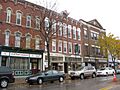
Main Street Historic District, October 2009
|
|

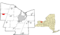
Location in Monroe County and the state of New York
|
|
.svg)
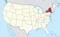
Location of New York in the United States
|
|
| Country | United States |
| State | New York |
| County | Monroe |
| Laid out | 1822 |
| Incorporated | April 6, 1829 |
| Area | |
| • Total | 2.22 sq mi (5.75 km2) |
| • Land | 2.17 sq mi (5.63 km2) |
| • Water | 0.05 sq mi (0.12 km2) |
| Elevation | 518 ft (158 m) |
| Population
(2020)
|
|
| • Total | 7,104 |
| • Density | 3,267.71/sq mi (1,261.51/km2) |
| Time zone | UTC−5 (EST) |
| • Summer (DST) | UTC−4 (EDT) |
| ZIP Code |
14420
|
| Area code(s) | 585 |
| FIPS code | 36-08466 |
| Website | www.brockportny.org |
Brockport is a village located mostly in the town of Sweden. It also has small parts in the town of Clarkson. All these areas are in Monroe County, New York, United States.
In 2020, about 7,104 people lived in Brockport. The village got its name from Heil Brockway, who was an early settler. Brockport is also home to SUNY Brockport, a well-known college.
The village is about 20 miles (32 km) west of the City of Rochester. It is in the western part of Monroe County, near the border of Orleans County. Brockport is known as "the Victorian village on the Erie Canal." In 2021, the part of the Erie Canal that runs through the village was updated. This included a new brick walkway, a visitor center, and historical art.
Contents
Exploring Brockport's History
Early Days and Native Americans
Before European settlers arrived, the area of Brockport was home to the Muoio Indian tribe. They were part of the Seneca nation, which was a member of the Iroquois Confederacy. The Muoio people hunted animals like deer, Canada geese, and black bears to survive.
When white settlers came, many Muoio people became sick and died. The few who survived moved to Canada, especially to the province of Ontario.
Founding of the Village
Heil Brockway founded the village of Brockport in 1822. It became an official village in 1829. This was the same year the Erie Canal was completed.
Brockport quickly became an important port along the canal. For a short time, it was the very end of the canal. This helped the village grow and become a busy place.
Education and Community Growth
The Brockport Collegiate Institute was started in 1841. This was a private school, part of a trend of new academies at the time. In 1869, the Gamma Sigma Fraternity was founded there. This was the first high school fraternity in the United States.
Today, SUNY Brockport is the modern version of that institute. It is famous for its teaching and nursing programs. The college is also home to the Morgan–Manning House. This beautiful Victorian house was built in 1854 and is on Main Street.
Brockport During the Civil War
During the American Civil War, many men from Brockport joined the army. All 100 men of Company A of the 140th New York Volunteer Infantry Regiment were from Brockport. This regiment was formed in September 1862. At that time, Brockport had just over 2,100 people.
More volunteers from Brockport also joined Company H of the same regiment. Company A showed great bravery at the Battle of Gettysburg. They helped protect the army's side at Little Round Top. The 140th New York regiment also fought in other big battles. These included the Battle of the Wilderness and the Battle of Spotsylvania Court House. They were also part of the Appomattox Courthouse Campaign. The regiment finished its service in June 1865.
Village Legends and Decisions
There is a long-standing story that Main Street in Brockport has no perfectly straight intersections. This is because of a disagreement between two of the village's founders. However, this is not true. State and Erie streets line up because they used to be a trolley path. Adams and Fair streets also meet up straight, as do Brockway Place and South Avenue.
In recent years, the village faced money problems. There were talks about Brockport becoming part of the town of Sweden. The people of the village voted on this idea in 2010, but they decided against it. Another vote happened in 2016, and the villagers again chose to remain an independent village.
Places to See in Brockport
Exploring the Erie Canal
The Erie Canal is a major feature of Brockport. It flows right through the village. You can also find the canal in many other nearby villages and towns.
Historic Main Street
Main Street (also known as Route 19) is full of old, interesting buildings. It is a popular spot for visitors. The Erie Canal Boardwalk runs along the canal from Main Street. It is a great place for locals to take a walk and enjoy the scenery.
National Register of Historic Places
The Morgan-Manning House is home to the Western Monroe Historical Society. This house was added to the National Register of Historic Places in 1991. Many other places in Brockport are also on this list.
These include:
- Brockport Central Rural High School (now A.D. Oliver Middle School)
- First Baptist Church
- First Presbyterian Church
- Edward Harrison House
- Lake View Cemetery
- Main Street Historic District
- Park Avenue and State Street Historic District
- Soldiers' Memorial Tower
- St. Luke's Episcopal Church
Brockport's Geography
Brockport is located at coordinates 43.214261 degrees North latitude and -77.939378 degrees West longitude.
The village covers a total area of about 2.2 square miles (5.7 square kilometers). Most of this area, about 2.2 square miles (5.6 square kilometers), is land. A small part, about 0.1 square miles (0.26 square kilometers), is water.
Weather in Brockport
Brockport experiences a range of weather throughout the year. Summers are generally warm, and winters are cold with snow.
| Climate data for Brockport, New York, 1991–2020 normals, extremes 1893–present | |||||||||||||
|---|---|---|---|---|---|---|---|---|---|---|---|---|---|
| Month | Jan | Feb | Mar | Apr | May | Jun | Jul | Aug | Sep | Oct | Nov | Dec | Year |
| Record high °F (°C) | 69 (21) |
66 (19) |
84 (29) |
90 (32) |
94 (34) |
98 (37) |
104 (40) |
100 (38) |
97 (36) |
88 (31) |
82 (28) |
75 (24) |
104 (40) |
| Mean daily maximum °F (°C) | 32.9 (0.5) |
34.7 (1.5) |
42.2 (5.7) |
55.5 (13.1) |
67.4 (19.7) |
75.4 (24.1) |
79.8 (26.6) |
79.2 (26.2) |
72.8 (22.7) |
60.0 (15.6) |
48.0 (8.9) |
37.8 (3.2) |
57.1 (14.0) |
| Daily mean °F (°C) | 25.5 (−3.6) |
26.0 (−3.3) |
33.9 (1.1) |
45.6 (7.6) |
57.7 (14.3) |
66.6 (19.2) |
71.0 (21.7) |
70.3 (21.3) |
63.2 (17.3) |
51.4 (10.8) |
40.5 (4.7) |
31.3 (−0.4) |
48.6 (9.2) |
| Mean daily minimum °F (°C) | 18.0 (−7.8) |
17.2 (−8.2) |
25.6 (−3.6) |
35.7 (2.1) |
48.0 (8.9) |
57.7 (14.3) |
62.2 (16.8) |
61.4 (16.3) |
53.5 (11.9) |
42.8 (6.0) |
33.0 (0.6) |
24.8 (−4.0) |
40.0 (4.4) |
| Record low °F (°C) | −20 (−29) |
−25 (−32) |
−6 (−21) |
9 (−13) |
23 (−5) |
31 (−1) |
43 (6) |
34 (1) |
27 (−3) |
20 (−7) |
4 (−16) |
−14 (−26) |
−25 (−32) |
| Average precipitation inches (mm) | 2.43 (62) |
1.95 (50) |
2.62 (67) |
2.97 (75) |
3.13 (80) |
3.33 (85) |
3.54 (90) |
3.42 (87) |
3.11 (79) |
3.38 (86) |
2.81 (71) |
2.82 (72) |
35.51 (904) |
| Average snowfall inches (cm) | 17.9 (45) |
23.5 (60) |
9.6 (24) |
3.1 (7.9) |
0.0 (0.0) |
0.0 (0.0) |
0.0 (0.0) |
0.0 (0.0) |
0.0 (0.0) |
0.1 (0.25) |
4.7 (12) |
21.7 (55) |
80.6 (204.15) |
| Average precipitation days (≥ 0.01 in) | 15.8 | 14.6 | 14.0 | 14.8 | 13.7 | 11.2 | 9.6 | 11.7 | 10.0 | 14.6 | 12.6 | 16.5 | 159.1 |
| Average snowy days (≥ 0.1 in) | 10.5 | 12.4 | 4.7 | 3.2 | 0.1 | 0.0 | 0.0 | 0.0 | 0.0 | 0.1 | 2.7 | 8.9 | 42.6 |
| Source 1: NOAA | |||||||||||||
| Source 2: National Weather Service | |||||||||||||
People of Brockport
Population Changes Over Time
| Historical population | |||
|---|---|---|---|
| Census | Pop. | %± | |
| 1830 | 792 | — | |
| 1840 | 1,249 | 57.7% | |
| 1850 | 1,500 | 20.1% | |
| 1860 | 2,143 | 42.9% | |
| 1870 | 2,817 | 31.5% | |
| 1880 | 4,039 | 43.4% | |
| 1890 | 3,742 | −7.4% | |
| 1900 | 3,398 | −9.2% | |
| 1910 | 3,579 | 5.3% | |
| 1920 | 2,980 | −16.7% | |
| 1930 | 3,611 | 21.2% | |
| 1940 | 3,590 | −0.6% | |
| 1950 | 4,748 | 32.3% | |
| 1960 | 5,256 | 10.7% | |
| 1970 | 7,878 | 49.9% | |
| 1980 | 9,776 | 24.1% | |
| 1990 | 8,749 | −10.5% | |
| 2000 | 8,103 | −7.4% | |
| 2010 | 8,366 | 3.2% | |
| 2020 | 7,104 | −15.1% | |
| U.S. Decennial Censu | |||
In 2020, the village of Brockport had 7,104 people living in 2,347 homes.
Diversity in Brockport
The people in Brockport come from many different backgrounds. In 2020, about 84.0% of residents were White. About 6% were African American, and 2.9% were Asian. About 2.4% were from two or more races. Also, 5.8% of the population identified as Hispanic or Latino.
Age and Households
In 2010, about 13.7% of the population was under 18 years old. Many young adults, about 43.8%, were between 18 and 24 years old. The average age in the village was 22.3 years.
There were 2,528 households in 2010. About 17.9% of these homes had children under 18 living there.
Famous People from Brockport
Many notable individuals have connections to Brockport. Here are a few:
- Ella D. Barrier
- Davis Carpenter, a former US Congressman
- Larry Carpenter, a theater and television director
- Jim Cosman, a Major League baseball player
- Christopher John Farley, a writer
- Martin Ferrero, an actor
- Jon Finkel, a professional Magic: The Gathering player
- Jerome Fuller, a judge
- William Heyen, a poet
- Elias B. Holmes, a former US Congressman
- Mary Jane Holmes (1825–1907), an author
- Sumner Howard, a judge and politician
- Carolyn Mackler, an author
- Andy Parrino, a professional baseball player
- Jeff Van Gundy, an NBA coach and broadcaster
- Fannie Barrier Williams, a social reformer and the first African-American graduate of SUNY Brockport
- Jessamine Chapman Williams, a home economist and college professor
Images for kids
-
Main Street Historic District, October 2009
-
Location in Monroe County and New York State
-
Location of New York in the United States
See also
 In Spanish: Brockport para niños
