
Webster, New York facts for kids
Quick facts for kids
Webster
|
|
|---|---|
| Motto(s):
Where Life Is Worth Living
|
|

Location in Monroe County and the state of New York
|
|
.svg)
Location of New York in the United States
|
|
| Country | United States |
| State | New York |
| County | Monroe |
| Established | February 6, 1840 |
| Area | |
| • Total | 35.24 sq mi (91.27 km2) |
| • Land | 33.53 sq mi (86.85 km2) |
| • Water | 1.71 sq mi (4.42 km2) |
| Elevation | 442 ft (135 m) |
| Population
(2020)
|
|
| • Total | 45,327 |
| • Density | 1,351.8/sq mi (521.9/km2) |
| Time zone | UTC-5 (EST) |
| • Summer (DST) | UTC-4 (EDT) |
| ZIP code |
14580
|
| Area code(s) | 585 |
| FIPS code | 36-055-78971 |
Webster is a town located in the northeastern part of Monroe County, New York, in the United States. It is named after Daniel Webster, a famous speaker and politician. In 2020, about 45,327 people lived here. Webster's motto is "where life is worth living." There is also a village called Webster inside the town. The town is part of the larger Rochester Metropolitan Area.
Contents
- Exploring Webster's Location and Size
- Understanding Webster's Population
- Webster's Past: A Brief History
- Learning in Webster: Schools and Education
- Sports and Community Spirit in Webster
- Important Events in Webster's History
- Well-Known People from Webster
- Neighborhoods and Areas in Webster
- Images for kids
- See also
Exploring Webster's Location and Size
The town of Webster is located next to Lake Ontario to the north. To the east, it borders Wayne County. On its west side, you'll find Irondequoit Bay and the town of Irondequoit. To the south, it shares a border with the town of Penfield.
Webster covers a total area of about 35.5 square miles (91.9 square kilometers). Most of this area, about 34.0 square miles (88.2 square kilometers), is land. The remaining 1.5 square miles (3.8 square kilometers) is water. A large part of the town's land, 550 acres, is covered by Webster Park. This park is located along the beautiful Lake Ontario waterfront.
Understanding Webster's Population
| Historical population | |||
|---|---|---|---|
| Census | Pop. | %± | |
| 1840 | 2,235 | — | |
| 1850 | 2,446 | 9.4% | |
| 1860 | 2,650 | 8.3% | |
| 1870 | 2,749 | 3.7% | |
| 1880 | 2,950 | 7.3% | |
| 1890 | 3,139 | 6.4% | |
| 1900 | 3,299 | 5.1% | |
| 1910 | 3,755 | 13.8% | |
| 1920 | 3,976 | 5.9% | |
| 1930 | 4,778 | 20.2% | |
| 1940 | 5,520 | 15.5% | |
| 1950 | 7,174 | 30.0% | |
| 1960 | 16,434 | 129.1% | |
| 1970 | 24,739 | 50.5% | |
| 1980 | 28,925 | 16.9% | |
| 1990 | 31,639 | 9.4% | |
| 2000 | 37,926 | 19.9% | |
| 2010 | 42,641 | 12.4% | |
| 2020 | 45,327 | 6.3% | |
| 2022 (est.) | 45,335 | 6.3% | |
| U.S. Decennial Census | |||
In 2020, the town of Webster had 45,327 residents. There were 19,432 households and 12,483 families living there. The population density was about 1352.4 people per square mile (521.9 people per square kilometer).
Most of the people in Webster, about 89.2%, are White. Other groups include 2.9% Black or African American, and 3.2% Asian. About 3.6% of the population identifies with two or more races. People of Hispanic or Latino background make up 4.2% of the population.
About 27.3% of households in Webster have children under 18 living with them. Many households, 49.9%, are married couples. The average household size is 2.31 people, and the average family size is 2.86 people.
The population's age spread shows that 20.4% are under 18 years old. About 20.8% are 65 years or older. The average age in Webster was 45.1 years in 2021.
In 2021, the typical household income in Webster was $81,345. For families, the median income was $108,065. The average income per person in the town was $43,896. A small number of families (3.0%) and individuals (5.3%) live below the poverty line.
Webster's Past: A Brief History
Webster became a town on February 6, 1840. Before that, it was part of a town called Penfield. The name "Webster" was chosen to honor Daniel Webster, a famous speaker. He gave a speech in nearby Rochester in 1837 that impressed local farmers.
The town of Webster has its own museum. This museum helps share the town's history with everyone. It has many displays that show what life was like in Webster long ago.
Learning in Webster: Schools and Education
Webster's public schools are managed by the Webster Central School District. This district serves students from kindergarten through 12th grade. All of Webster's middle schools (Spry, Willink) and high schools (Thomas, Schroeder) are located within the town.
Five of the seven elementary schools (DeWitt Road, Klem North, Klem South, Schlegel Road, State Road) are also in Webster.
There are also several private schools in the area:
- Hillside Children's Center Halpern Education Center (grades 6–12)
- Lakeside Alpha (grades 3–12), a Christian school
- Rochester Christian School (pre-K–8), a Calvinist school
- St. Rita School (pre-K–6), run by the Roman Catholic Diocese of Rochester
- Webster Early Learning Center (pre-K–1)
- Webster Montessori School (elementary), which serves students from the Webster school district
Sports and Community Spirit in Webster
Webster is known for its strong sports community. In 2005, Sports Illustrated magazine even named Webster the "Number 1 Sportstown in New York." This award recognized the town's dedication to sports for its community.
Webster is part of Section V (Five) of the New York State Public High School Athletic Association. This section includes schools from Monroe County and several other nearby counties.
High School Sports Achievements
Webster's high school teams have achieved great success.
- The Webster Schroeder High School football team has won three New York State Championships in Class AA. They once had an amazing winning streak of 31 games.
- The Webster Thomas High School hockey team won the New York State Championship in Division II in 2008. They won again in 2014.
- The Webster Thomas soccer team has won the sectional title three years in a row. They even made it to the state finals in 2007.
- The men's lacrosse team won a sectional title in 2009.
- The women's lacrosse team also won a section V title in 2007.
Sports Facilities and Clubs
Webster has excellent sports facilities. These include two lighted stadiums, a hockey/soccer complex, an indoor track, and an Olympic-size indoor pool.
The town is home to several sports clubs for young athletes. These include the Webster Cyclones (youth hockey), Webster Lacrosse Club, and Webster Soccer Association. The Webster Soccer Association hosts the annual Webster Lakefront Classic. This is one of the largest soccer tournaments in the Greater Rochester area. It takes place every year on Father's Day weekend.

Webster also has a summer college baseball team called the Lake Ontario Ridgemen. They play their home games at Basket Road Stadium. The Ridgemen are part of the New York Collegiate Baseball League.
Important Events in Webster's History
Webster has experienced some difficult times. In December 2011, a tragic fire occurred in a home, resulting in the loss of lives.

In December 2012, another serious event took place. A person started a fire and then harmed volunteer firefighters who arrived to help. Two firefighters, Mike Chiapperini and Tomasz Kaczowka, sadly died. Two others, Theodore Scardino and Joseph Hofstetter, were seriously injured. A police officer from Greece, New York, was also hurt. Seven homes were destroyed because firefighters could not put out the flames until the area was safe. This event led to a new law in New York State. This law helps protect emergency workers.
Well-Known People from Webster
Many notable people have connections to Webster:
- Elma Bellini – A New York Supreme Court Justice.
- Joseph L. Biehler – A U.S. Army major general.
- Brian Bliss – A former player for the USA men's national soccer team.
- Paul Buchheit – The lead developer of gmail and creator of the Google motto "Don't be Evil."
- Grant Catalino – A lacrosse player.
- Susan Gibney – An actress.
- Gregor Gillespie – A professional mixed martial artist.
- Lou Gramm – The lead singer of the rock band Foreigner.
- Kara Lynn Joyce – An Olympic medalist swimmer for the US National Team.
- Pat Kelly – A professional American Football player for the National Football League Denver Broncos.
- Brian Kozlowski – A professional American Football player for the National Football League Washington Redskins.
- Edward Tsang Lu – A Space Shuttle astronaut who also lived on the International Space Station.
- Wendy O. Williams – The late singer of The Plasmatics.
Neighborhoods and Areas in Webster
Webster is made up of several communities and locations:
- Avalon Estates – A neighborhood off Phillips Road.
- Lake Road – A neighborhood also called Fieldcrest, located along Lake Ontario.
- Forest Lawn – A neighborhood in the northwest, on the shore of Lake Ontario.
- Gallant Fox – A neighborhood near Hedges Nine Mile Point Restaurant and Mama Lor’s Restaurant.
- Glen Edith – A spot on the west side of town, by Irondequoit Bay.
- Oakmonte – A large neighborhood in the central-southern part of town with homes and apartments.
- Parkwood – A smaller neighborhood with a community park, located off Klem Road.
- Union Hill – A small community on the border with Wayne County.
- Webster (village), New York – The village located in the center of the town.
- West Webster – A small community at the intersection of Ridge and Gravel Road.
Images for kids
-
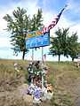
Memorial for Chiapperini and Kaczowka
See also
 In Spanish: Webster (Nueva York) para niños
