Phelps (village), New York facts for kids
Quick facts for kids
Phelps, New York
|
|
|---|---|
|
Village
|
|

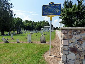
Pioneer Cemetery
|
|
| Country | United States |
| State | New York |
| County | Ontario |
| Area | |
| • Total | 1.16 sq mi (3.00 km2) |
| • Land | 1.16 sq mi (3.00 km2) |
| • Water | 0.00 sq mi (0.00 km2) |
| Elevation | 522 ft (159 m) |
| Population
(2020)
|
|
| • Total | 1,851 |
| • Density | 1,599.83/sq mi (617.78/km2) |
| Time zone | UTC-5 (Eastern (EST)) |
| • Summer (DST) | UTC-4 (EDT) |
| ZIP code |
14532
|
| Area code(s) | 315 |
| FIPS code | 36-57518 |
| GNIS feature ID | 0960275 |
Phelps is a small village located in Ontario County, New York, United States. In 2020, about 1,851 people lived there. The village was named after Oliver Phelps, who was one of its first owners.
The Village of Phelps is found in the middle of the larger Town of Phelps. It is located north of the city of Geneva. Every August, the village hosts a fun Sauerkraut Festival.
Contents
History of Phelps Village
The area where Phelps is now was first settled around 1793. This made it one of the earliest places to be settled in the town. The village was officially recognized as "Phelps" in 1855. Before that, it was known as "Vienna." People also used to jokingly call it "Woodpecker City." This nickname might have been a playful way to describe how busy the villagers always seemed to be.
Historic Buildings in Phelps
Several important buildings in Phelps are listed on the National Register of Historic Places. This means they are recognized for their historical value. These buildings include the First Baptist Church of Phelps, St. John's Episcopal Church, Phelps Town Hall, and the Dr. John Quincy Howe House.
Interestingly, the village of Vienna, Virginia was named after Phelps when it was still called Vienna.
Geography and Location
Phelps is located at coordinates 42°57′30″N 77°3′44″W. This means it is in the western part of New York State.
How Big is Phelps?
According to the United States Census Bureau, the village covers a total area of about 1.2 square miles (3.0 square kilometers). All of this area is land.
Roads and Waterways
Phelps is located south of the New York State Thruway (Interstate 90), a major highway. New York State Route 96 is another important road that goes through the village, running from east to west.
A stream called Flint Creek flows through the village. It eventually empties into the Canandaigua Outlet. Phelps is also part of the beautiful Finger Lakes District and is north of Seneca Lake.
Population and People
The population of Phelps has changed over the years. Here is a look at how many people have lived in the village during different census years:
| Historical population | |||
|---|---|---|---|
| Census | Pop. | %± | |
| 1870 | 1,355 | — | |
| 1880 | 1,369 | 1.0% | |
| 1890 | 1,336 | −2.4% | |
| 1900 | 1,306 | −2.2% | |
| 1910 | 1,354 | 3.7% | |
| 1920 | 1,200 | −11.4% | |
| 1930 | 1,397 | 16.4% | |
| 1940 | 1,499 | 7.3% | |
| 1950 | 1,650 | 10.1% | |
| 1960 | 1,887 | 14.4% | |
| 1970 | 1,989 | 5.4% | |
| 1980 | 2,004 | 0.8% | |
| 1990 | 1,978 | −1.3% | |
| 2000 | 1,969 | −0.5% | |
| 2010 | 1,980 | 0.6% | |
| 2020 | 1,851 | −6.5% | |
| U.S. Decennial Census | |||
Who Lives in Phelps?
In 2000, there were 1,969 people living in Phelps. These people made up 791 households and 521 families. Most residents were White (98.48%). A small number of people were from other racial groups or identified as Hispanic or Latino.
About 31.9% of households had children under 18 living with them. Many households (52.8%) were married couples. The average household had 2.47 people, and the average family had 3.01 people.
Age and Income
The population in Phelps was spread out across different age groups. About 25.6% of residents were under 18 years old. The median age was 38 years.
In 2000, the average income for a household in the village was $40,758. For families, the average income was $48,207. A small percentage of families (3.9%) and individuals (6.1%) lived below the poverty line.
See also

- In Spanish: Phelps (villa) para niños
 | Chris Smalls |
 | Fred Hampton |
 | Ralph Abernathy |


