Pine Creek Gorge facts for kids
Quick facts for kids Pine Creek Gorge |
|
|---|---|

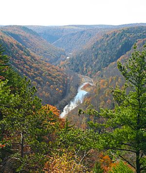
Pine Creek Gorge in autumn.
|
|
| Lua error in Module:Location_map at line 420: attempt to index field 'wikibase' (a nil value). | |
| Location | Tioga, Lycoming, and Clinton counties, Pennsylvania |
| Nearest city | Waterville |
| Designated | 1968 |
Pine Creek Gorge, often called The Grand Canyon of Pennsylvania, is a huge, deep valley in north-central Pennsylvania. It was carved out over many years by Pine Creek into the Allegheny Plateau. This amazing gorge stretches for about 47-mile (76 km) and is surrounded by the Tioga State Forest, covering a vast area of about 160,000 acres (650 km2).
The gorge starts near Ansonia and Wellsboro, following U.S. Route 6 south. Its deepest point is 1,450 feet (440 m) deep near Waterville. At Leonard Harrison and Colton Point State Parks, the gorge is over 800 feet (240 m) deep. The distance from one side (rim) to the other is about 4,000 feet (1,200 m).
Contents
How the Pine Creek Gorge Formed
About 20,000 years ago, something incredible happened that shaped Pine Creek Gorge. Before then, Pine Creek flowed north. But a giant sheet of ice, called the Laurentide Continental Glacier, started to melt and move back. As it melted, it left behind a huge pile of rocks, soil, and other debris. This debris acted like a dam, blocking Pine Creek.
A large lake formed behind this natural dam near where the town of Ansonia is today. Eventually, the lake overflowed, causing a massive flood that rushed south. This powerful flood carved a deep channel, creating the gorge we see now. The water continued its journey south, eventually joining the West Branch Susquehanna River.
Protected Areas in Pine Creek Gorge
Pine Creek Gorge is a special place, so it has several protections to keep it beautiful and natural.
National Natural Landmark Designation
The gorge is part of the National Natural Landmark program. This includes Colton Point and Leonard Harrison State Parks, along with parts of the Tioga State Forest. This protected area covers about 12 miles (19 km) of Pine Creek between Ansonia and Blackwell. The National Park Service says the gorge has "superlative scenery, geological and ecological value." It's considered one of the best examples of a deep gorge in the eastern United States.
State Natural Area and Scenic River
Pennsylvania also protects the gorge as the Pine Creek Gorge Natural Area. This area is about 12,163-acre (4,922 ha) and is the second largest State Natural Area in Pennsylvania. Within this, 699 acres (283 ha) of Colton Point and Leonard Harrison State Parks are even more protected as a State Park Natural Area. This state-protected area follows Pine Creek for about 12 miles (19 km) and is about 2 miles (3.2 km) wide.
Pine Creek itself, along with the gorge walls, is also protected as a Pennsylvania Scenic River. This means the state helps keep the creek wild and beautiful, preventing things like dam-building that could harm it. This protection helps ensure that people can continue to enjoy the natural beauty of Pine Creek for many years to come.
History of Pine Creek Gorge
The history of Pine Creek Gorge is rich with stories of early travelers, lumberjacks, and the changing landscape.
Native American History
For thousands of years, Native Americans used Pine Creek Gorge as an important travel route. They would hike through the gorge to reach a seasonal hunting camp near what is now Ansonia. This area was later named after Anson Phillips, who built a lumber mill there, attracting the first settlers.
The Lumber Era

When William Penn and his Quaker colonists arrived in Pennsylvania in 1682, most of the land was covered in thick forests. These forests had huge eastern white pine trees, some 3 to 6 feet (1 to 2 m) wide and over 150 feet (46 m) tall. There were also giant eastern hemlock trees and many other hardwoods.
Early settlers used this wood to build homes, barns, and ships. As the demand for wood grew, the lumber industry became very important in Pennsylvania. Trees were used for fuel, to make leather (tannin), for construction, furniture, and barrels.
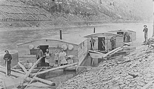
By the early 1800s, lumberjacks reached Pine Creek Gorge. The white pine from Pine Creek was considered the "best timber in the world for making fine ship masts." So, these trees were the first to be cut down on a large scale. The cut logs, called spars, were floated down Pine Creek to the Susquehanna River, and then to shipbuilders in Baltimore. After delivering the wood, the lumbermen would walk all the way back home along the old Pine Creek Path.

Over time, fewer pine trees were left, so lumberjacks started cutting down more hemlocks and hardwoods. Instead of picking out specific trees, they began to clear-cut entire areas. In 1879, Henry Colton oversaw the cutting of white pine in the area that is now Colton Point State Park. The overlook there is named after him.
By the early 1900s, almost all the old-growth forests in the gorge had been clear-cut. This left the land bare, with only dried tree tops, which were a huge fire risk. Many areas burned, leaving the soil damaged and barren. This period was sometimes called the "Pennsylvania Desert." Floods became more common, and much of the wildlife disappeared.
Recent History and Rebirth
Since the end of the lumber era, the forests in Pine Creek Gorge have slowly grown back. Today, you can find trees that are over 100 years old. Many animals have returned to these woods, including white-tailed deer, beaver, turkeys, black bears, river otters, and even bald eagles.
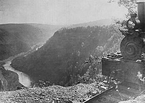
Visitors can explore the gorge and see its plants and animals in the state parks. There are also many hiking trails and the Pine Creek Rail Trail. This trail, which opened in 1996, follows the path of an old railroad for 64 miles (103 km) from Wellsboro Junction to Jersey Shore. It's a great way to experience the beauty of the gorge.
Images for kids
 | Jessica Watkins |
 | Robert Henry Lawrence Jr. |
 | Mae Jemison |
 | Sian Proctor |
 | Guion Bluford |


