White Deer Creek facts for kids
Quick facts for kids White Deer Creek |
|
|---|---|
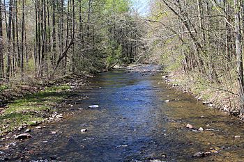
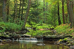
White Deer Creek looking upstream near Old Furnace
|
|
| Native name | Woap'-achtu-hanne |
| Physical characteristics | |
| Main source | valley to the north of Hall Mountain in Miles Township, Centre County, Pennsylvania 1,872 ft (571 m) |
| River mouth | West Branch Susquehanna River in West Buffalo Township, Union County, Pennsylvania near White Deer 446 ft (136 m) |
| Length | 28 mi (45 km) |
| Basin features | |
| Progression | West Branch Susquehanna River → Susquehanna River → Chesapeake Bay |
| Tributaries |
|
White Deer Creek is a stream in Pennsylvania, USA. It flows into the West Branch Susquehanna River. The creek is about 28 miles (45 km) long. It runs through Centre County and Union County.
The land area that drains into the creek, called its watershed, covers about 45.1 square miles (117 km2). Some parts of the creek are not as clean as they should be. The amount of water flowing in the creek can change a lot. It can be as low as 3 cubic feet per second (0.085 m3/s) or as high as 169 cubic feet per second (4.8 m3/s).
White Deer Creek is a "freestone stream," meaning it flows over rocks and gravel. It's in a mountainous area. The creek is fairly small and flows through a narrow valley. This valley can be up to 1,000 feet (300 m) wide in some spots.
Much of the land around the creek is covered by forests. Large parts are owned by the Pennsylvania Bureau of Forestry. The creek's watershed is a special area for coldwater fish and migrating fish. You can find both brook trout and brown trout here. The creek is also stocked with trout for fishing.
The name White Deer Creek comes from the Native American word Woap'-achtu-hanne. This means "white-deer stream." The creek has been on maps since 1759. Many mills were built along it in the 1700s and 1800s. Important industries in the past included cutting timber and farming. Many bridges have been built over the creek.
A lot of White Deer Creek is in Bald Eagle State Forest. It also flows through McCalls Dam State Park. People enjoy fishing and canoeing on the creek.
Contents
Journey of White Deer Creek
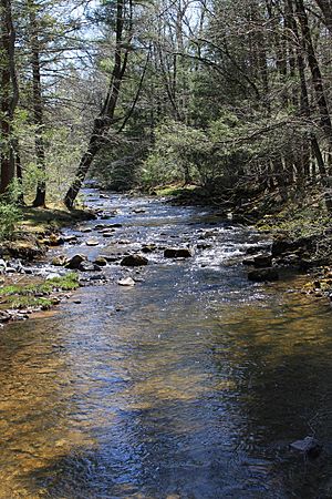
White Deer Creek starts in a valley north of Hall Mountain. This is in Miles Township, Centre County. It begins near the border of Centre and Clinton County.
The creek flows east through a deep, narrow valley. After about a mile, it gets its first named stream joining it, Tunis Run, from the right side. Then, the creek winds east-northeast for several miles. It passes near mountains like McCall Mountain. Eventually, it leaves Centre County.
Creek's Path Through Union County
When White Deer Creek leaves Centre County, it enters Hartley Township in Union County. It keeps winding east-northeast for a short distance. Then it flows into Lewis Township. Here, the creek continues its winding path for a few miles. It passes more mountains before entering West Buffalo Township.
In West Buffalo Township, the creek flows east-northeast for over a mile. It then turns northeast and receives Cowbell Hollow from the left. Soon after, it turns northwest, then north-northeast. Here, it gets its longest tributary, Sand Spring Run, from the left.
The creek then flows east-northeast again, close to Interstate 80. It receives Mile Run from the left. After passing Little Mountain, it enters White Deer Township. The creek heads east and receives Lick Run, its last named tributary, from the left.
White Deer Creek then turns northeast, then east. For several miles, it flows generally east. It runs between South White Deer Ridge and Catharines Crown/Nittany Mountain, still next to Interstate 80. The valley gets wider, and the mountains on its south side disappear.
The creek turns northeast, then east-southeast, then east-northeast. It crosses Interstate 80. It flows east for a few more miles, still following South White Deer Ridge. Finally, it crosses US Route 15. A short distance later, it joins the West Branch Susquehanna River.
White Deer Creek meets the West Branch Susquehanna River about 15.76 miles (25.36 km) upstream from the larger river's mouth.
Streams Joining White Deer Creek
White Deer Creek has five named streams that flow into it. These are Lick Run, Mile Run, Sand Spring Run, Cowbell Hollow, and Tunis Run.
- Lick Run joins the creek about 10.77 miles (17.33 km) upstream from its mouth. It drains an area of 2.10 square miles (5.4 km2).
- Mile Run joins about 11.82 miles (19.02 km) upstream. It drains 1.57 square miles (4.1 km2).
- Sand Spring Run joins about 12.48 miles (20.08 km) upstream. It drains 4.94 square miles (12.8 km2).
- Cowbell Hollow joins about 13.58 miles (21.85 km) upstream. Its watershed is the smallest, at 0.26 square miles (0.67 km2).
- Tunis Run joins about 25.62 miles (41.23 km) upstream. It drains 1.43 square miles (3.7 km2).
Water Quality and Flow
Some parts of White Deer Creek are healthy. However, other parts of the creek's watershed are not as healthy. In one section, the water quality is affected by changes to the habitat. In another part, there is mercury in the water from an unknown source.
The amount of water flowing in White Deer Creek has been measured many times. It has ranged from 3.0 to 169 cubic feet per second (0.085 to 4.786 m3/s). Between 1969 and 1973, the average flow was about 73.06 cubic feet per second (2.069 m3/s).
The water in the creek is usually clear. It only gets cloudy after big storms. The water temperature can range from very cold (−0.1 °C (31.8 °F)) to warm (23.1 °C (73.6 °F)). Even in warmer months, the creek stays cool enough for fish.
Land and Weather Around the Creek
The creek's mouth is 446 feet (136 m) above sea level. Its source is much higher, at 1,872 feet (571 m) above sea level. White Deer Creek is about 20 feet (6.1 m) wide. The slope of the creek changes, but it averages 40 feet per mile (7.6 m/km).
The valleys around White Deer Creek are mostly narrow. In some places, the valley walls rise steeply from the creek banks. This made it hard to build roads there. However, some parts of the valley are wider, about 1,000 feet (300 m) across.
White Deer Creek is known as a "freestone stream." It has many fallen trees and branches in the water. These are called "strainers." The creek's path can also split into several smaller channels in some areas.
The creek flows through a very narrow valley. In its upper parts, it's small for canoeing. The town of White Deer often has flooding problems. This is because it's on the creek's floodplain and the valley is narrow. The land around the creek is mountainous with steep ridges.
There are some camps along White Deer Creek. But the area is not heavily developed until the last few miles of the creek. There are many rocky rapids near Nittany Mountain. The fast-moving water, called whitewater, only stops in the lowest parts of the creek.
A 4-foot (1.2 m) dam is on White Deer Creek. It's used for water supply. The creek also has problems with erosion at its mouth.
The creek's path is winding. It flows through sandstone rock formations. The creek bed is rocky, and its banks are high. The flat land next to the creek, called the floodplain, is one of the biggest in Union County. There are many shallow, rocky areas, called riffles, where the creek flows past large rocks.
In the lower parts of the White Deer Creek watershed, the soil is coarse. You'll find lots of sand, silt, gravel, and large rocks. Clay is found near old dams. The valley sides have sandstone and dolomite rock outcrops. The tops of the ridges are made of strong sandstone.
The watershed gets about 35 to 45 inches (89 to 114 cm) of rain each year. The creek stays clear except after big storms.
Creek's Surroundings
The watershed of White Deer Creek covers 45.1 square miles (117 km2). The creek's mouth is near the town of White Deer. The watershed is mostly in eastern Centre County and northern Union County. It is one of the main streams in Union County.
White Deer Creek flows next to Interstate 80 for a long distance. However, you usually can't see or hear the highway from the creek.
The Pennsylvania-American Water Company uses a small dam on White Deer Creek for water supply. This water serves about 41,000 people in nearby counties. Upstream of this dam, over 99 percent of the watershed is forested. The Pennsylvania Bureau of Forestry owns most of this land.
Other groups also own small parts of the land. These include the Pennsylvania Bureau of State Parks and the Pennsylvania-American Water Company. The Pennsylvania Department of Transportation owns some land too. There is also farmland between White Deer Creek, Interstate 80, and US Route 15.
Things like power lines, a natural gas pipeline, and unpaved roads are in the watershed. These could potentially affect the water supply. There is a special zone where trees are selectively cut. This zone is 100 feet (30 m) wide on both sides of the creek in state forest lands.
History of White Deer Creek
White Deer Creek was officially named in 1979. It has also been called Whitedeer Creek or South Branch White Deer Creek. The name comes from a Native American word meaning "white-deer stream." The creek appeared on old maps as early as 1759.
In 1774, Catharine Smith started building a sawmill and a gristmill on the creek. She also built a boring mill in 1776. This mill made gun barrels for the Continental Army during the American Revolutionary War. An early settlement near the creek was destroyed in 1777.
A state road was built in 1824, connecting Bellefonte to the mouth of White Deer Creek. By the 1830s, many mills were on the creek. These included mills for grinding grain, making cloth, cutting wood, and even a distillery. In 1845, a furnace was built that used the creek's water power to make pig iron.
John McCall started a logging camp in the upper part of the watershed by 1860. He used special dams to float logs downstream to his mill. Later, Ario Pardee created a system to float logs all the way to the mouth of the creek. From there, they were taken to Watsontown for milling.
Around 1900, the Kulp Lumber Mill processed millions of board feet of timber from White Deer Creek. They used a narrow gauge railway system. In the early 1900s, farming was the main industry in the watershed. The White Deer and Loganton Railroad followed the creek for its entire length. It ran for 24 miles (39 km) until its tracks were removed in 1916.
Many bridges have been built over White Deer Creek over the years.
- A steel bridge for T-514 was built in 1915. It's 65.9 feet (20.1 m) long.
- A bridge for State Route 1003 was built in 1958. It's 86.9 feet (26.5 m) long.
- The US Route 15 bridge was built in 1963. It's 228.0 feet (69.5 m) long.
- Another bridge for State Route 1011 was built in 1963. It's 89.9 feet (27.4 m) long.
- Two bridges for Interstate 80 were built in 1970. Both are 136.2 feet (41.5 m) long.
- A steel bridge was built in 1974. It's 68.9 feet (21.0 m) long.
In 2000, a group called the White Deer Creek Restoration Committee received a grant. They used it to study problems with the creek's stability and find solutions.
Wildlife and Plants
The White Deer Creek watershed is a special place for fish. It's known as a High-Quality Coldwater Fishery. Wild trout naturally reproduce in the creek for about 18.40 miles (29.61 km). The creek is also stocked with brook trout and brown trout for fishing. This has been happening since the 1930s.
Rare animals have been seen near White Deer Creek. The land phase of the red-spotted newt was sometimes seen near the White Deer Dam. Beavers used to live in large numbers in the watershed. Other animals seen here include deer, bears, wildcats, and porcupines. Birds like whippoorwills and wild turkeys also live here. In the 1930s, rattlesnakes and copperheads were also observed.
Most of the White Deer Creek valley is covered by forests. You'll find dense areas of mountain laurel. The forests mainly have hemlock trees and mixed oak trees. Experts suggest keeping a forested area along the creek banks. This helps protect the water.
The original very old trees in the watershed were cut down in the 1890s. By the late 1930s, new trees had grown back. These included hardwoods, hemlocks, pines, and aspens. Some of these new trees were up to 1 foot (0.30 m) wide. However, a few old pine or oak trees remained. Thick rhododendrons and mountain laurel also grew densely. At higher elevations, the plants became less dense, with only scrub oak forests on the ridge tops.
Fun Activities
The White Deer Creek area has been a popular spot for outdoor fun since the 1930s. Better roads made it easier for people to visit. Wealthier residents from nearby towns built weekend cabins here. Hunting and fishing clubs were also active.
You can canoe on at least 17.1 miles (27.5 km) of White Deer Creek. This is best during spring snowmelt or after heavy rain. The creek's difficulty for canoeing ranges from easy to moderately challenging. The scenery is described as "good."
Much of White Deer Creek flows through state forest lands. McCalls Dam State Park, which is 8 acres (3.2 ha) big, is also near the creek. The state park is surrounded by Bald Eagle State Forest. The creek flows through this forest from its start to its lower parts.
The scenery around the creek is described as "thick and beautiful." It's a good place for fishing, even though it can be a bit challenging. The creek is known for its "excellent dry fly stream" fishing.
A marathon called Dam Full crosses the upper parts of White Deer Creek. The Mid State Trail also crosses the creek.
 | Roy Wilkins |
 | John Lewis |
 | Linda Carol Brown |


