White Deer Hole Creek facts for kids
Quick facts for kids White Deer Hole Creek |
|
|---|---|
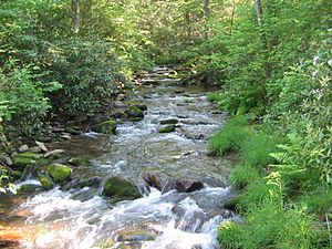
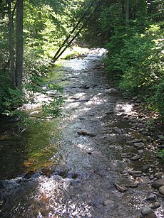
White Deer Hole Creek near the Fourth Gap of South White Deer Ridge
|
|
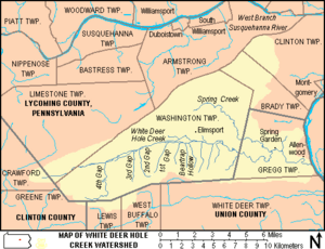
Map showing White Deer Hole Creek, its major tributaries and watershed
|
|
|
Location of the Mouth of White Deer Hole Creek in Union County, Pennsylvania
|
|
| Country | United States |
| State | Pennsylvania |
| Counties | Clinton, Lycoming, Union |
| Physical characteristics | |
| Main source | Crawford Township, Clinton County 2,180 ft (660 m) 41°05′19″N 77°11′38″W / 41.08861°N 77.19389°W |
| River mouth | West Branch Susquehanna River Gregg Township, Union County 445 ft (136 m) 41°06′02″N 76°53′22″W / 41.10056°N 76.88944°W |
| Length | 20.5 mi (33.0 km) |
| Discharge (location 2) |
|
| Basin features | |
| Basin size | 67.2 sq mi (174 km2) |
| Tributaries |
|
White Deer Hole Creek is a stream in Pennsylvania, USA. It flows for about 20.5 mi (33.0 km) and joins the West Branch Susquehanna River. The creek passes through Clinton, Lycoming, and Union counties. Its waters eventually reach the Chesapeake Bay.
The area around White Deer Hole Creek is called its watershed. This watershed covers 67.2 sq mi (174 km2) and includes parts of ten different townships. The creek flows through a valley in the Appalachian Mountains, where you can find different types of rocks like sandstone, limestone, and shale.
Most of the watershed is still natural, with about 71.6% covered by forests, including parts of Tiadaghton State Forest. The western part of the creek has very clean water. It's even called "Class A Wild Trout Waters" by the Pennsylvania Fish and Boat Commission. This means it's a great place for trout to live and grow naturally. Other parts of the creek and its main branch, Spring Creek, are stocked with fish. The area is also popular for outdoor activities like canoeing, hunting, camping, hiking, and horseback riding.
Long ago, Native American trails followed parts of the creek. Settlers arrived around 1770 but had to leave during the American Revolution. They came back later, and the creek became an important boundary for Lycoming County in 1795. A special railroad was built along the creek from 1901 to 1904 to help with logging. Today, some small-scale logging still happens. During World War II, a factory that made TNT was built in the watershed. This factory later became a federal prison. Most of the towns and farms are found in the eastern part of the valley, including several Amish communities.
Contents
What's in a Name?
The name "White Deer Hole Creek" is quite unique, and there are two main ideas about where it came from.
How Did White Deer Hole Creek Get Its Name?
One idea is that the name comes from the Lenape language, an old Native American language. The word Woap-achtu-woalhen means "white-deer digs a hole." Early maps from the 1750s show similar names like Opauchtooalin or Opaghtanoten, which meant "White Flint Creek." By 1770, maps started using "White Deer hole."
Another story comes from John Farley, who was 88 years old in 1870. His family settled by the creek in 1787. He said the creek was named because "a white deer is said to have been killed at an early day in a low hole or pond of water that once existed where my father built his mill." This "hole" was a large, low area of land that later became covered by water when his father built a mill and a dam. This mill was near the creek's end, in the village of Allenwood.
The name "White Deer Hole Creek" is special because no other place in the United States has the exact same name on maps. Even though the whole creek is called this now, in 1870, only the eastern part had this name. The western part was known as "South Creek." Today, "South Creek" is no longer used for the stream, but there's still a "South Creek Road" nearby.
Many people also call the valley where the creek flows "White Deer valley." It's important not to confuse White Deer Hole Creek with White Deer Creek, which is a different stream located just south of it.
Tributaries of White Deer Hole Creek
A tributary is a smaller stream that flows into a larger one. White Deer Hole Creek has one main named tributary called Spring Creek. It also has five unnamed smaller streams that flow into it from the South White Deer Ridge. These are found in places called Beartrap Hollow, First Gap, Second Gap, Third Gap, and Fourth Gap.
Where Does the Creek Flow?
White Deer Hole Creek starts in Crawford Township, in Clinton County. The western part of the creek flows through Tiadaghton State Forest.
Journey Through Lycoming County
The creek flows east and soon crosses into Lycoming County, entering Limestone Township. It then enters Washington Township, which has more of the creek than any other area. Here, it receives water from unnamed streams in the Fourth, Third, Second, and First Gaps of South White Deer Ridge.
After the Third Gap, the creek leaves Tiadaghton State Forest. It also stops being a "Class A Wild Trout Waters" area between the Second and First Gaps. The creek then passes south of the village of Elimsport.
Flowing into Union County
White Deer Hole Creek continues its journey east into Gregg Township in Union County. Here, its main tributary, Spring Creek, joins it. Spring Creek starts north of Elimsport and flows through Pennsylvania State Game Lands No. 252.
The creek then flows past the small community of Spring Garden and the village of Allenwood. Finally, it meets the West Branch Susquehanna River. The straight-line distance from where the creek starts to where it ends is about 16 miles (26 km).
Near its mouth, U.S. Route 15 and the Union County Industrial Railroad cross the creek. Pennsylvania Route 44 also runs roughly parallel to the creek between Elimsport and Allenwood. Many smaller roads follow the creek's path, especially in its eastern two-thirds.
Creek's Elevation and Path
The creek starts at an elevation of 2,180 feet (660 m) and ends at 445 feet (136 m). This means it drops 1,735 feet (529 m) over its 20.5 miles (33.0 km) length. This drop helps the water flow. The creek's path is not perfectly straight; it has some curves, especially near its mouth.
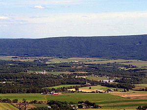
For its entire length, White Deer Hole Creek flows along the north side of South White Deer Ridge, which is a mountain ridge. North White Deer Ridge and Bald Eagle Mountain form the northern edge of the creek valley. The creek has many small streams flowing into it from the south side (from South White Deer Ridge) and fewer from the north side.
Creek's Geology
White Deer Hole Creek is located in a mountainous area with sandstone, limestone, and shale rocks. This region is part of the Ridge-and-valley Appalachians. The mountains around the creek are made of older rocks, while the valley itself has younger rocks. There are no coal, natural gas, or oil fields in this area.
The creek flows through a narrow mountain valley with steep sides in its upper parts. In the middle and lower parts, it has steep mountain slopes to the south, but a wider valley with rolling hills to the north.
Water Flow Measurements
From 1961 to 1995, the United States Geological Survey (USGS) measured the water flow of White Deer Hole Creek at the Gap Road bridge. The highest water flow recorded was 4,200 cubic feet (120 m3) per second on June 22, 1972, during Hurricane Agnes. The lowest flow was 135 cubic feet (3.8 m3) per second on November 26, 1986.
The USGS also measured the water flow near the creek's mouth between 1970 and 1975. The average flow there was 70.4 cubic feet (1.99 m3) per second, ranging from 33 cubic feet (0.93 m3) to 111 cubic feet (3.1 m3) per second.
White Deer Hole Creek Watershed
The White Deer Hole Creek watershed covers about 67 square miles (170 km2). Most of this area, about 48 square miles (120 km2), is covered by forests, and 19 square miles (49 km2) is used for farming.
Who Lives in the Watershed?
In 2000, about 2,672 people lived in the White Deer Hole Creek watershed. Since the 1970s, many Amish families have moved to the Elimsport area. By 1995, there were over 200 Amish people living in more than twenty families. Elimsport has Amish-owned shops for things like harnesses, machine repair, and food. A new one-room school was built nearby in 1997.
Most of the watershed (81.6%) is in Lycoming County. Smaller parts are in Union County (17.3%) and Clinton County (1.1%). Spring Creek is the largest tributary, draining about 31% of the entire watershed.
Water Quality and Pollution
In the past, cutting down large areas of forest and a factory that made explosives affected the water quality of White Deer Hole Creek. Water running off from farms can also cause pollution.
However, the area has improved. In 2001, the Pennsylvania Department of Environmental Protection called the drainage basin "a high quality watershed." This means the water is generally very clean.
The area gets about 40 to 42 inches of rain each year. Pennsylvania gets a lot of acid rain, which can be harmful to streams. Because the creek flows through certain types of rock, it can't easily cancel out the acid from the rain. This makes it important to protect the creek's plants and animals from acid rain. The "Class A Wild Trout Waters" section of the creek has very low alkalinity, meaning it's more sensitive to acid.
Fun Activities in the Watershed
White Deer Hole Creek is a great place for outdoor fun!
Canoeing and Kayaking
If you like whitewater sports, the creek is good for canoeing and kayaking in the spring or after heavy rains. There are about 10.6 miles (17.1 km) of easy whitewater (Class 1) from Back Road bridge to U.S. Route 15. You can start even further upstream for a more challenging ride (Class 2 whitewater), but watch out for fallen trees.
Fishing
The Pennsylvania Fish and Boat Commission has named parts of White Deer Hole Creek as "Class A Wild Trout Waters." This means it's an excellent place to catch naturally grown trout. The unnamed stream in Fourth Gap is also a "Class A Wild Trout Waters" area. Other parts of the creek and Spring Creek are stocked with trout, so you can fish there during trout season. You might also find other fish like carp, catfish, and pike.
Hunting and Camping
You can go hunting, trapping, and fishing in Tiadaghton State Forest and the 3,018 acres (1,221 ha) Pennsylvania State Game Lands No. 252, as long as you have the right licenses. The creek from its source to Spring Creek is considered a "High Quality-Cold Water Fishery." Many private hunting and fishing clubs are also in the area. Popular animals to hunt include black bears, white-tailed deer, and wild turkeys.
Hiking and Horseback Riding
Part of the 261-mile (420 km) Pennsylvania Mid State Trail runs along White Deer Hole Creek. This trail is only for hiking. There are other hiking trails too, and some are part of the 120-mile (190 km) Central Mountains Shared Use Trails System. These trails are also open for horseback riding and mountain biking. In winter, some trails are used for cross-country skiing and snowmobiling.
You can also go primitive camping in the state forest, but some areas need a permit. Small campfires are usually allowed, except during certain times of the year when only self-contained stoves are permitted.
A Look Back in Time
The area around White Deer Hole Creek has a rich history.
Native American Trails
The first people known to live in the Susquehanna River valley were the Susquehannocks. Later, the Lenape (or Delaware) people lived in the West Branch Susquehanna River valley. Two important Native American trails followed parts of White Deer Hole Creek.
The Great Island Path was a major trail that followed the West Branch Susquehanna River. It turned west at Allenwood and followed White Deer Hole Creek to near Elimsport. From there, it went northwest to another valley and then north to the Great Island, near the city of Lock Haven. Today, Pennsylvania Route 44 roughly follows this part of the trail.
Culbertson's Path also followed White Deer Hole Creek from Allenwood. It then followed Spring Creek north, crossed a mountain, and went to the river near Duboistown. This path was later used by settlers to take grain to a mill. It was also part of the Underground Railroad, a secret network that helped enslaved people escape to freedom before the American Civil War. Escaped slaves would sometimes walk in creeks to hide their scent from dogs. Today, a "Culbertson's Trail" still exists for hiking.
How Lycoming County Was Formed
When Lycoming County was created on April 13, 1795, White Deer Hole Creek was used as part of its southern border. The county's boundaries have changed since then, but the White Deer Hole Creek watershed still marks part of the county line in the south.
Early Settlers
Before settlers arrived, the area near the creek's mouth showed signs of being lived in by Native Americans for a very long time. The land around White Deer Hole Creek was bought by the Pennsylvania government in 1768. The first settlers came to the valley in 1769 or 1770. By 1778, there were many landowners, but many had to leave during the American Revolutionary War.
During the war, British allies and Native Americans attacked settlements in the Susquehanna valley. Many settlers fled their homes in what was called the "Big Runaway." They left their farms and belongings and went south to Sunbury. Their abandoned homes were sometimes burned. Some settlers returned later, but had to flee again in 1779.
After the war, more people began to settle in the area. By 1787, there were only fourteen families in the valley. The first mill to grind grain was built on the creek in 1789, and more were built in the years that followed.
Lumber and Logging Railroad
Over time, much of the land along White Deer Hole Creek was cleared of trees. Small sawmills were built in the 1800s. A much larger logging company, Vincent Lumber Company, operated from 1901 to 1904. They built a special narrow railroad from Elimsport west into the forest and east to Allenwood. This railroad, called the "Allenwood and Western Railroad," ran next to the creek. The logging stopped in 1904 when most of the trees were gone.
From 1900 to 1935, Pennsylvania bought much of the clear-cut land, which later became Tiadaghton State Forest. In the 1930s, groups like the Civilian Conservation Corps (CCC) built roads and trails in the forest. One CCC camp was located along the creek near Elimsport.
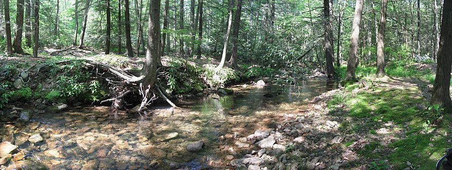
Today, some small-scale logging still happens in the watershed. The forests have grown back and are now a mix of oak trees, blueberries, and mountain laurel bushes. White Deer Hole Creek also has hemlock trees and rhododendron bushes along its banks. An Amish-owned sawmill in Elimsport continues to operate.
From Ordnance Plant to Federal Prison
During World War II, the government built a large factory called the Susquehanna Ordnance Depot to make TNT. This factory was partly in the White Deer Hole Creek watershed. In 1942, residents were asked to leave their homes and farms in the area. The village of Alvira disappeared, and most of the buildings were torn down.
After the war, the factory closed. In 1950, part of the land was given to the Federal Bureau of Prisons. In 1952, prisoners from another prison started to be housed there. In 1957, the "Allenwood Prison Camp" was built, which later became the "Federal Correctional Institute, Allenwood." This prison grew to be one of the largest federal prisons in the United States.
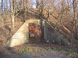
Some of the land was sold to create the "White Deer Golf Course." In 1973, some prison land was leased to Lycoming County for a landfill. The remaining 3,018 acres (1,221 ha) became Pennsylvania State Game Lands 252. Many of the old concrete bunkers from the factory are still there, but the area is now a mix of forests and wetlands, making it a great place for many different birds and animals.
The watershed is home to lots of wildlife. You can find painted turtles, snapping turtles, muskrats, frogs, rabbits, red foxes, and white-tailed deer. Many birds live here too, like warblers, hawks, wood ducks, herons, and kingfishers. Other common animals include gray squirrels, groundhogs, raccoons, crows, and various songbirds.
Some local people have reported seeing unusual things or experiencing strange activities in the bunker areas. While there haven't been official investigations, some individuals have looked into these reports.
 | Calvin Brent |
 | Walter T. Bailey |
 | Martha Cassell Thompson |
 | Alberta Jeannette Cassell |


