Mile Run (White Deer Creek tributary) facts for kids
Quick facts for kids Mile Run |
|
|---|---|

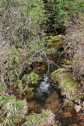
Mile Run looking upstream
|
|
| Physical characteristics | |
| Main source | valley between Fawn Ridge and Pine Flat in West Buffalo Township, Union County, Pennsylvania 1,546 ft (471 m) |
| River mouth | White Deer Creek in West Buffalo Township, Union County, Pennsylvania near White Deer 997 ft (304 m) 41°03′47″N 77°03′58″W / 41.06317°N 77.06616°W |
| Length | 1.9 mi (3.1 km) |
| Basin features | |
| Progression | White Deer Creek → West Branch Susquehanna River → Susquehanna River → Chesapeake Bay |
| Basin size | 1.57 sq mi (4.1 km2) |
| Tributaries |
|
Mile Run is a small stream, or tributary, that flows into White Deer Creek in Union County, Pennsylvania. It's about 1.9 miles (3.1 km) long. This stream runs through West Buffalo Township.
Mile Run is special because it's known as a "spring run". This means it gets its water from natural underground springs. Wild trout live and reproduce in the stream. Many tiny plant species called bryophytes also grow nearby.
Where Mile Run Flows
Mile Run starts in a valley. This valley is located between two places called Fawn Ridge and Pine Flat in West Buffalo Township.
The stream first flows towards the east-northeast. After a short distance, it gets water from a smaller stream that joins it from the left side. Then, Mile Run slowly turns south. Another small stream also joins it from the left.
As it continues south, Mile Run flows between Pine Flat and Little Mountain. It then leaves its valley and goes under Interstate 80. After this, the stream turns towards the east-southeast. A short way downstream, Mile Run meets and joins White Deer Creek. It joins White Deer Creek about 11.82 miles (19.02 km) before White Deer Creek reaches its own mouth.
Geography and Water
The place where Mile Run joins White Deer Creek is about 997 feet (304 meters) above sea level. Where Mile Run begins, its source, is higher up at about 1546 feet (471 meters) above sea level.
The area of land that collects water for Mile Run is called its drainage basin or watershed. This watershed covers about 1.57 square miles (4.07 square kilometers). The entire stream is located within the Williamsport SE area, as mapped by the United States Geological Survey. The end of the stream is near the town of White Deer.
Most of the watershed, about 1.25 square miles (3.24 square kilometers), is in Union County. On an average day, the amount of water flowing in Mile Run is about 2.58 cubic feet per second (0.073 cubic meters per second).
History of Mile Run
Mile Run was officially added to the Geographic Names Information System on August 2, 1979. This system keeps track of names and locations of places in the United States.
A railroad called the White Deer Valley Railroad used to pass near Mile Run. It was built in 1901 to help move logs from the forests. Later, it became part of the White Deer and Loganton Railroad in 1906.
Animals and Plants
Mile Run is a great place for wild trout. These fish naturally reproduce in about 1.24 miles (2 km) of the stream's length. The type of trout found here is the brook trout.
Many different kinds of tiny plants called bryophytes have been seen near Mile Run. Scientists observed about 20 different species here in 1995. Some of these included Hygroamblystegium tenax, Hypnum pallescens, Platyhypnidium riparioides, Platylomella lescurii, and Hypnum lindbergii.
 | Leon Lynch |
 | Milton P. Webster |
 | Ferdinand Smith |


