
Bald Eagle Creek (West Branch Susquehanna River tributary) facts for kids
For the Bald Eagle Creek in Blair County, Pennsylvania, see Bald Eagle Creek (Little Juniata River tributary).

Bald Eagle Creek is a river in Pennsylvania, United States. It flows for about 55 miles (89 kilometers) and is a branch, or tributary, of the West Branch Susquehanna River. Most of Bald Eagle Creek is located in Centre County.
This creek flows through a long valley called the Bald Eagle Valley. This valley is at the base of a mountain ridge also named Bald Eagle Mountain. The creek eventually reaches the town of Lock Haven.
There is also a shorter creek with the same name, Bald Eagle Creek. This other creek flows south from the same area near the border of Blair County and Centre County. It ends in the Little Juniata River near Tyrone.
Contents
Exploring Bald Eagle Creek
A railroad track, part of the Nittany and Bald Eagle Railroad, runs along both Bald Eagle creeks. This means you can often see the creek from the train tracks!
Important roads also cross the creek. Interstate 80 goes over the creek between the towns of Snow Shoe and Bellefonte. U.S. Route 322 crosses it between Port Matilda and State College.
A lot of water from the nearby Nittany Valley flows into Bald Eagle Creek. This happens through special openings in the Bald Eagle Mountain ridge called water gaps. These are like natural pathways for water to flow through the mountains.
History Along the Creek
Near the creek in a town called Unionville, there's an important place called the Fisher Farm Site. This is an archaeological site, which means it's a place where scientists study old human history by digging up artifacts and remains. It tells us about people who lived there long ago.
Towns Along Bald Eagle Creek
Many towns are located along the longer Bald Eagle Creek, from its start to where it joins the bigger river. Here are some of them:
Images for kids
-
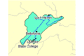
A map showing the Bald Eagle Creek watershed.

