Bald Eagle Valley facts for kids

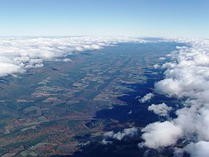
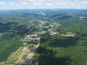
The Bald Eagle Valley is a long, low area in central Pennsylvania, United States. It's like a big ditch between two important land features: the Allegheny Front and the Bald Eagle Mountain ridge. Water from this valley flows into the Bald Eagle Creek.
This valley is part of the Ridge-and-Valley Appalachians, a region with many parallel mountains and valleys. It's located southwest of the West Branch Susquehanna Valley (where Williamsport is) and northwest of the Nittany Valley (where State College is).
The Bald Eagle Valley stretches through the middle of Centre County and the southern part of Clinton County. It goes from Port Matilda all the way to Lock Haven. You'll find the Bald Eagle Area School District and Bald Eagle Township here. The Bald Eagle State Park is also in the valley. This park has a large lake called the Joseph Foster Sayers Reservoir, which was made by building a dam on Bald Eagle Creek near Howard.
Contents
Main Towns in the Valley

Here are the main towns you'll find in the Bald Eagle Valley, listed from southwest to northeast along the Bald Eagle Creek:
Farming in the Valley
Farming is an important activity in the Bald Eagle Valley. In the upper part of the valley, the Bald Eagle Creek flows at the base of the mountain ridge. Here, you'll see long, narrow farm fields right next to the creek. There are also fields along the smaller valleys that branch off from the main creek. Some smaller fields are on the gentle hills near the creek.
As you go further down the valley, the flat area near the creek gets wider. This means there are larger farm fields. Between the flat areas and the higher plateau, there are two different kinds of land. Closer to the creek, there are steep, wooded hills that are not good for farming. But closer to the plateau, the hills are gentler. Here, you'll find a mix of fields, pastures for animals, and wooded areas. Farmers in the valley commonly grow crops like corn, hay, alfalfa, and winter wheat.
Getting Around the Valley

Roads for Travel
U.S. Alternate Route 220 used to be the main road through the valley. Now, the main US 220 route has moved to the Nittany Valley. The road in the Bald Eagle Valley is now called U.S. 220 Alternate.
Interstate 80 (I-80) crosses the valley from east to west between Snow Shoe, Pennsylvania and Bellefonte, Pennsylvania. U.S. Route 322 also crosses the valley through Port Matilda. Interstate 99 (I-99) runs through the upper valley, mostly along the ridge. It then joins U.S. 322 near Port Matilda.
Old Canals
A canal system called the Bald Eagle and Spring Creek Navigation started being built from Lock Haven in 1834. It reached Howard by 1837 and Milesburg by 1847. It finally reached Bellefonte in 1848.
This canal was useful at first. However, trains started to become popular during the American Civil War. The canal was badly damaged by floods in 1865 and was never rebuilt.
Railroad History
The first railroad in Centre County, the Bellefonte and Snow Shoe Railroad, began construction in 1858. It entered the valley near Milesburg. By 1862, a line was finished that went up a side valley to reach the timber and coal areas of Snow Shoe. This line climbed a very steep hill using a special series of turns called switchbacks.
The Pennsylvania Railroad helped build the Bald Eagle Valley Railroad line. This line ran through the valley from Tyrone to Lock Haven. When it was finished in 1865, it used part of the Bellefonte & Snow Shoe Railroad track. The Pennsylvania Railroad bought the Bellefonte & Snow Shoe Railroad in 1881. Today, the Nittany and Bald Eagle Railroad still uses the lines from Tyrone to Lock Haven and Bellefonte.
Air Travel
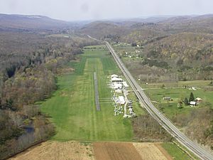
The Ridge Soaring Gliderport is the only airport in the valley. It's active most of the year, offering pilot training and glider rides. Another airport, Peterson Memorial Airport near Tyrone, closed in 1976 and is now an industrial park.
How the Valley Was Formed
The Bald Eagle Valley is in the western part of the Ridge-and-Valley Appalachians, which is a section of the larger Appalachian Mountains. Millions of years ago, when the supercontinent Pangaea was forming, huge forces pushed and folded the Earth's rock layers. This created a massive mountain range, much like the Himalayas today.
One of these ancient mountains was called the Nittany Arch. Over time, this huge mountain wore away due to erosion. The oldest rock layers, which were deep inside the mountain, are now visible on the east side of the Bald Eagle ridge. Younger rocks, from the outer parts of the ancient mountain, are found in the Bald Eagle Valley. The youngest rocks are at the foot of the Allegheny Front.
The rock layers in the valley were pushed from lying flat to standing almost straight up. Because of this, the valley is very straight. It's like looking at the pages of a giant history book made of rock!
The Silurian Tuscarora Formation is a very hard rock. It resisted erosion, which is why the Bald Eagle ridge still stands tall above the valley. The Bald Eagle Creek flows on a bed of softer rock called Devonian Hamilton Group Shale. Other strong rocks form parallel hills in the valley, some almost as high as the main ridge.
 | Dorothy Vaughan |
 | Charles Henry Turner |
 | Hildrus Poindexter |
 | Henry Cecil McBay |

