Unionville, Centre County, Pennsylvania facts for kids
Quick facts for kids
Unionville, Pennsylvania
|
|
|---|---|
|
Borough
|
|

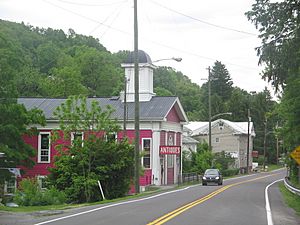
Looking northeast into Unionville along ALT US 220
|
|

Location in Centre County, Pennsylvania
|
|
| Country | United States |
| State | Pennsylvania |
| County | Centre |
| Settled | 1848 |
| Incorporated (borough) | 1859 |
| Area | |
| • Total | 0.24 sq mi (0.61 km2) |
| • Land | 0.24 sq mi (0.61 km2) |
| • Water | 0.00 sq mi (0.00 km2) |
| Elevation | 787 ft (240 m) |
| Population
(2010)
|
|
| • Total | 291 |
| • Estimate
(2019)
|
289 |
| • Density | 1,219.41/sq mi (471.37/km2) |
| Time zone | Eastern (EST) |
| • Summer (DST) | EDT |
| Area code(s) | 814 |
| FIPS code | 42-78616 |
| GNIS feature ID | 1215064 |
Unionville is a small town, called a borough, located in Centre County, Pennsylvania, in the United States. It's nestled in the beautiful Bald Eagle Valley and is part of the larger State College area. In 2010, about 291 people lived here.
Contents
Discover Unionville's Past
Long ago, between the years 1200 and 1600, a Native American village from the Late Woodland period stood near Unionville. This village, now called the Fisher Farm site, was right by the Bald Eagle Creek.
The town of Unionville officially started in 1848. It was built where temporary camps for lumberjacks used to be. In 1859, Unionville became the third borough in Centre County. A few years later, in 1864, it became a stop on the Bald Eagle Valley Railroad, which helped the town grow.
In the 1860s, a unique pink Methodist church was built in Unionville. Many years later, in 2015, this church was turned into an art exhibit known as Marry's Pink Church.
In 2024, Unionville experienced flooding due to heavy rains from Tropical Storm Debby.
Unionville's Historic Buildings
In 1979, almost all of Unionville was recognized as a special place called the Unionville Historic District. This means its old buildings and areas are very well-preserved, looking much like they did before World War I. Because of this, the district was added to the National Register of Historic Places. Nearly 200 buildings in the borough were considered important parts of this historic area.
Where is Unionville Located?
Unionville is located at coordinates 40.90698 degrees North and -77.87550 degrees West.
The United States Census Bureau says that Unionville covers a total area of 0.3 square miles (0.7 square kilometers). All of this area is land, with no water.
Who Lives in Unionville?
| Historical population | |||
|---|---|---|---|
| Census | Pop. | %± | |
| 1870 | 320 | — | |
| 1880 | 399 | 24.7% | |
| 1890 | 348 | −12.8% | |
| 1900 | 360 | 3.4% | |
| 1910 | 343 | −4.7% | |
| 1920 | 311 | −9.3% | |
| 1930 | 304 | −2.3% | |
| 1940 | 321 | 5.6% | |
| 1950 | 341 | 6.2% | |
| 1960 | 371 | 8.8% | |
| 1970 | 375 | 1.1% | |
| 1980 | 361 | −3.7% | |
| 1990 | 284 | −21.3% | |
| 2000 | 313 | 10.2% | |
| 2010 | 291 | −7.0% | |
| 2019 (est.) | 289 | −0.7% | |
| Sources: | |||
In 2010, there were 291 people living in Unionville. These people lived in 123 households, and 83 of these were families. The town had about 1,099 people per square mile.
Most people in Unionville were White (97.6%). A small number were Black or African American (0.3%), Asian (0.7%), or from other backgrounds. About 0.7% of the population was Hispanic or Latino.
About 26.8% of households had children under 18 living with them. Most households (53.7%) were married couples. The average household had 2.37 people, and the average family had 2.84 people.
The population was spread out by age. About 19.2% were under 18, and 14.4% were 65 or older. The average age in Unionville was 42 years old.
The average income for a household in Unionville was $34,792. For families, the average income was $31,964. About 22.9% of all people in Unionville lived below the poverty line. This included 44.4% of those under 18.
Famous People from Unionville
Herman Fisher, who founded the well-known Fisher Price toy and game company, was born in Unionville.
See also
 In Spanish: Unionville (condado de Centre) para niños
 | Misty Copeland |
 | Raven Wilkinson |
 | Debra Austin |
 | Aesha Ash |


