Snyder County, Pennsylvania facts for kids
Quick facts for kids
Snyder County
|
|
|---|---|
Snyder County Courthouse
|
|
Location within the U.S. state of Pennsylvania
|
|
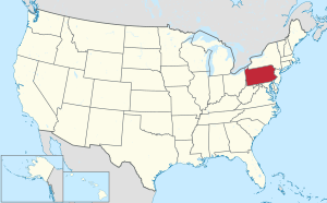 Pennsylvania's location within the U.S. |
|
| Country | |
| State | |
| Founded | March 2, 1855 |
| Named for | Simon Snyder |
| Seat | Middleburg |
| Largest borough | Selinsgrove |
| Area | |
| • Total | 332 sq mi (860 km2) |
| • Land | 329 sq mi (850 km2) |
| • Water | 2.8 sq mi (7 km2) 0.8%% |
| Population
(2020)
|
|
| • Total | 39,736 |
| • Density | 123/sq mi (47/km2) |
| Time zone | UTC−5 (Eastern) |
| • Summer (DST) | UTC−4 (EDT) |
| Area code | 570 & 272, 717 & 223 |
| Congressional district | 12th |
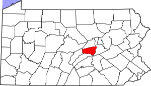
Snyder County is a place in Pennsylvania, a state in the USA. In 2020, about 39,736 people lived here. Its main town, or county seat, is Middleburg. Snyder County became its own county in 1855. It was created from parts of Union County. This county is in the central part of Pennsylvania.
Contents
History of Snyder County
People from Germany who lived in Berks and Lancaster counties first settled Snyder County in the 1740s. It officially became its own county on March 2, 1855. The county is named after Simon Snyder, a famous person who was the governor of Pennsylvania three times, from 1808 to 1817. He lived in Selinsgrove. The county seat, Middleburg, was planned in 1800 and became an official town in 1864.
Geography and Nature
Snyder County covers about 332 square miles. Most of this is land (329 square miles), and a small part (2.8 square miles) is water. It is the fifth-smallest county in Pennsylvania by size.
Mountains and Rivers
Snyder County is in the Appalachian Mountains. It has two long, parallel mountain ridges called Shade Mountain and Jacks Mountain. Between these ridges, you'll find steep hills, gentle hills, and flat valleys with creeks. The Susquehanna River forms the eastern border of the county.
Farms and Forests
Farming is very important here, with over 400 active farms. About half of the county is covered in forests. These woods are home to many wild animals, making it a great place for hunting.
Weather and Climate
Snyder County has a humid continental climate. This means it has hot summers. In Selinsgrove, the average temperature is about 27.4°F in January and 72.8°F in July. In Beavertown, it's about 26.6°F in January and 72.1°F in July.
Neighboring Counties
Snyder County shares borders with these counties:
- Union County (north)
- Northumberland County (east)
- Juniata County (south)
- Mifflin County (west)
People and Population
| Historical population | |||
|---|---|---|---|
| Census | Pop. | %± | |
| 1860 | 15,035 | — | |
| 1870 | 15,606 | 3.8% | |
| 1880 | 17,797 | 14.0% | |
| 1890 | 17,651 | −0.8% | |
| 1900 | 17,304 | −2.0% | |
| 1910 | 16,800 | −2.9% | |
| 1920 | 17,129 | 2.0% | |
| 1930 | 18,836 | 10.0% | |
| 1940 | 20,208 | 7.3% | |
| 1950 | 22,912 | 13.4% | |
| 1960 | 25,922 | 13.1% | |
| 1970 | 29,269 | 12.9% | |
| 1980 | 33,584 | 14.7% | |
| 1990 | 36,680 | 9.2% | |
| 2000 | 37,546 | 2.4% | |
| 2010 | 39,702 | 5.7% | |
| 2020 | 39,736 | 0.1% | |
| U.S. Decennial Census 1790–1960 1900–1990 1990–2000 2010–2017 2010-2020 |
|||
In 2010, there were 39,702 people living in Snyder County. Most people (97%) were White. About 1.2% were Black or African American, and 2% were Hispanic or Latino. The average income for a household in 2014 was $48,718.
Population in 2020
| Race | Number | Percent |
|---|---|---|
| White | 36,992 | 93.1% |
| Black or African American | 504 | 1.3% |
| Native American | 32 | 0.08% |
| Asian | 296 | 0.7% |
| Pacific Islander | 11 | 0.03% |
| Other/Mixed | 924 | 2.32% |
| Hispanic or Latino | 977 | 2.45% |
Local Areas and Statistics
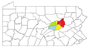
The U.S. government calls Snyder County the Selinsgrove, PA Micropolitan Statistical Area. In 2010, this area was the 15th most populated in Pennsylvania. Snyder County is also part of a larger area called the Bloomsburg–Berwick–Sunbury, PA Combined Statistical Area. This bigger area includes Snyder, Columbia, Montour, Northumberland, and Union Counties.
Utilities and Services
Electricity and Water
All towns in Snyder County get electricity from PPL Electric Utilities, Inc. Water services come from different local companies or private wells.
Gas and Communication
UGI Penn Natural Gas provides natural gas to some areas. Many propane dealers serve the countryside. Verizon and EvenLink offer phone services. Cable TV is available from Service Electric Cablevision, Nittany Media, Inc., and Beaver Springs Community TV Association. High-speed internet is mainly provided by Verizon, EvenLink, and Service Electric Cablevision.
Economy
Since 2001, the manufacturing industry in Snyder County has lost the most jobs. About 427 jobs, or 7.2% of all jobs in this industry, were lost. This made up 36% of all job losses in the county since 2001.
Education in Snyder County
Colleges and Universities
- Susquehanna University
Public Schools
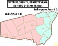
Students in Snyder County attend schools in these public school districts:
- Midd-West School District
- Selinsgrove Area School District
Private Schools
Many private schools are also in Snyder County, including:
- Bannerville School, McClure
- Chapman Parochial School, Port Trevorton
- Gospel Christian Academy, Selinsgrove
- Jacks Mountain School, McClure
- Kantz Church School, Middleburg
- Lakeview School, Port Trevorton
- Leaning Oak School, Mount Pleasant Mills
- Locust Grove School, Mount Pleasant Mills
- Meadow View School, Trevorton
- New Story School, Selinsgrove (for special education)
- Palace Creek School, Mount Pleasant Mills
- Penn View Christian Academy, Penns Creek
- Shady Grove Parochial School, Port Trevorton
- White Oak School, Liverpool
Transportation
Snyder County has two main roads. U.S. Routes 11/15 run through the eastern part of the county, near the Susquehanna River. The planned Central Susquehanna Valley Thruway will also go through the county. U.S. Route 522 starts in Selinsgrove and goes west through Kreamer and Middleburg. Other state routes like Route 35, 235, 104, and 204 also cross the county.
Towns and Communities
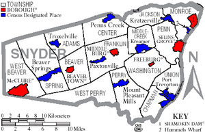
Pennsylvania has different types of towns. In Snyder County, you'll find boroughs and townships.
Boroughs (Towns)
- Beavertown
- Freeburg
- McClure
- Middleburg (This is the county seat)
- Selinsgrove
- Shamokin Dam
Townships (Rural Areas)
- Adams
- Beaver
- Center
- Chapman
- Franklin
- Jackson
- Middlecreek
- Monroe
- Penn
- Perry
- Spring
- Union
- Washington
- West Beaver
- West Perry
Other Communities
These are smaller communities that are not official towns but are recognized by the U.S. Census Bureau for data collection.
Community Size Ranking (2010 Census)
This table shows the population of the main communities in Snyder County from the 2010 census.
† county seat
| Rank | City/Town/etc. | Type | Population (2010 Census) |
|---|---|---|---|
| 1 | Selinsgrove | Borough | 5,654 |
| 2 | Shamokin Dam | Borough | 1,686 |
| 3 | Hummels Wharf | CDP | 1,353 |
| 4 | † Middleburg | Borough | 1,309 |
| 5 | Beavertown | Borough | 965 |
| 6 | McClure | Borough | 941 |
| 7 | Kreamer | CDP | 822 |
| 8 | Port Trevorton | CDP | 769 |
| 9 | Penns Creek | CDP | 715 |
| 10 | Beaver Springs | CDP | 674 |
| 11 | Freeburg | Borough | 575 |
| 12 | Richfield (partially in Juniata County) | CDP | 549 |
| 13 | Mount Pleasant Mills | CDP | 464 |
| 14 | Kratzerville | CDP | 383 |
| 15 | Paxtonville | CDP | 265 |
| 16 | Troxelville | CDP | 221 |
Culture and Heritage
Snyder County is known for its unique Pennsylvania German language and culture. It has a rich farming history. You can also find special folk art called fraktur, Kentucky rifles, and wood products here. The Middleswarth chip factory is also famous.
The county hosts many fairs, festivals, and auctions. These events help keep the local traditions alive. Some important historical buildings include the Governor Snyder Mansion and the Schoch Block House. You can also see ruins of the Pennsylvania Canal and old covered bridges. Snyder County is home to Snyder-Middleswarth State Park and the Tall Timbers Natural Area. There are also thirteen historical markers around the county.
Historical Markers in Snyder County
- Pennsylvania Canal (Susquehanna Division) – Near Port Trevorton
- Simon Snyder – South of Selinsgrove
- Simon Snyder Mansion (Plaque) – In Selinsgrove
- Coxey’s Army – In Selinsgrove
- Penns Creek Massacre – North of Selinsgrove
- Penns Creek Massacre (Plaque) – Near Penns Creek
- Schoch Blockhouse – At Kreamer
- Susquehanna University – West of Selinsgrove
- Albany Purchase – North of Selinsgrove
- Harris Ambush (Plaque) – West of Selinsgrove
- Sunbury – North of Selinsgrove
- Shikellamy – North of Selinsgrove, near Shikellamy State Park
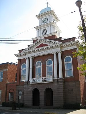
- Snyder County – At the county courthouse in Middleburg
See also
 In Spanish: Condado de Snyder para niños
 | William L. Dawson |
 | W. E. B. Du Bois |
 | Harry Belafonte |


