
Richfield, Pennsylvania facts for kids
Quick facts for kids
Richfield, Pennsylvania
|
|
|---|---|

Keystone Marker
|
|

Richfield, Pennsylvania
Location in Pennsylvania

Richfield, Pennsylvania
Location in the United States
|
|
| Country | United States |
| State | Pennsylvania |
| Counties | Juniata, Snyder |
| Townships | Monroe, West Perry |
| Area | |
| • Total | 1.17 sq mi (3.02 km2) |
| • Land | 1.16 sq mi (3.01 km2) |
| • Water | 0.00 sq mi (0.01 km2) |
| Elevation | 656 ft (200 m) |
| Population
(2020)
|
|
| • Total | 530 |
| • Density | 455.72/sq mi (176.01/km2) |
| Time zone | UTC-5 (Eastern (EST)) |
| • Summer (DST) | UTC-4 (EDT) |
| ZIP code |
17086
|
| Area code(s) | 717 |
| FIPS code | 42-64488 |
| GNIS feature ID | 1185007 |
Richfield is a small community in Pennsylvania, United States. It's known as an unincorporated community, which means it's not officially a city or town with its own local government. It's also a census-designated place (CDP), which is an area the government defines for counting people.
Richfield is special because it's located across two different counties: Juniata County and Snyder County. In 2010, about 549 people lived there.
Contents
Where is Richfield Located?
Richfield is found in the eastern part of Juniata County and the southern part of Snyder County. You can find it at these coordinates: 40°41′18″N 77°6′43″W / 40.68833°N 77.11194°W.
Most of Richfield is in Monroe Township in Juniata County. A smaller part is in West Perry Township in Snyder County. The border between these two townships and counties follows the West Branch Mahantango Creek. This creek flows from west to east, just north of the town's center.
Getting Around Richfield
Pennsylvania Route 35 is the main road that goes through Richfield. If you travel northeast on this road, you'll reach Selinsgrove in about 15 miles. If you go southwest, you'll get to Mifflintown in about 17 miles. Mifflintown is important because it's the main town, or county seat, for Juniata County.
How Big is Richfield?
According to the United States Census Bureau, the Richfield area covers about 3.0 square kilometers (about 1.17 square miles). Most of this area is land. Only a tiny part, about 0.17%, is water.
Who Lives in Richfield?
| Historical population | |||
|---|---|---|---|
| Census | Pop. | %± | |
| 2020 | 530 | — | |
| U.S. Decennial Census | |||
In the year 2000, there were 459 people living in Richfield. They lived in 160 homes, and 123 of these were families.
Many homes (about 31.3%) had children under 18 living there. Most homes (71.3%) were married couples living together. About 20.6% of all homes had just one person living there. Also, 13.1% of homes had someone 65 years old or older living alone.
The average home had about 2.58 people, and the average family had about 2.97 people.
Age Groups in Richfield
The people in Richfield are spread across different age groups:
- About 21.4% were under 18 years old.
- About 6.5% were between 18 and 24 years old.
- About 25.3% were between 25 and 44 years old.
- About 20.9% were between 45 and 64 years old.
- About 25.9% were 65 years old or older.
The average age of people in Richfield was 43 years old.
Images for kids
-
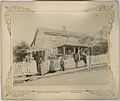
Postcard/picture of Unknown African family in front of home, Richfield Pa 1890s
-
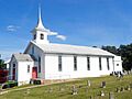
United Methodist Church
-

United Church of Christ
-
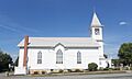
St. Johns Lutheran
.jpg)


See also
 In Spanish: Richfield (Pensilvania) para niños
