
Indiana County, Pennsylvania facts for kids
Quick facts for kids
Indiana County
|
||
|---|---|---|

Indiana County Courthouse
|
||
|
||

Location within the U.S. state of Pennsylvania
|
||
 Pennsylvania's location within the U.S. |
||
| Country | ||
| State | ||
| Founded | November 3, 1806 | |
| Seat | Indiana | |
| Largest borough | Indiana | |
| Area | ||
| • Total | 834 sq mi (2,160 km2) | |
| • Land | 827 sq mi (2,140 km2) | |
| • Water | 7.3 sq mi (19 km2) 0.9% | |
| Population
(2020)
|
||
| • Total | 83,246 | |
| • Density | 101/sq mi (39/km2) | |
| Time zone | UTC−5 (Eastern) | |
| • Summer (DST) | UTC−4 (EDT) | |
| Congressional district | 15th | |

Indiana County is a county in the state of Pennsylvania. It is located in the west-central part of Pennsylvania. In 2020, about 83,246 people lived there. The main town, or county seat, is Indiana.
Indiana County is part of the Pittsburgh region. It is also known as the "Christmas Tree Capital of the World." This is because it ships over one million Christmas trees every year! Farming is a very important part of its economy.
Contents
History of Indiana County
Indiana County got its name from the "Indiana Grant of 1768." This was a large area of land that the Iroquois Six Nations were forced to give up. It was part of the Fort Stanwix Treaty of 1768. The Iroquois had used this land for hunting for a long time.
Early American settlers wanted to develop this area. Some people even suggested it become a new British colony called Vandalia. However, the Revolutionary War stopped these plans.
After the war, both Virginia and Pennsylvania claimed the land. The federal government decided that this area belonged to Pennsylvania. Indiana County was officially created on March 30, 1803. It was formed from parts of Westmoreland and Clearfield counties. It was formally organized in 1806.
Indiana County and the Underground Railroad
Indiana County was a very important place for the Underground Railroad. This was a secret network that helped enslaved people escape to freedom. Many people in Indiana County were against slavery. They helped guide runaway slaves to safe hiding spots. From there, the enslaved people would continue their journey to freedom in Canada.
At least 90 people in the county were known as "conductors" or "agents." These brave individuals risked their lives to help others. Local leader James Moorhead published anti-slavery newspapers. These papers helped spread the word about the fight against slavery.
Geography of Indiana County
Indiana County covers about 834 square miles. Most of this area, about 827 square miles, is land. The rest, about 7.3 square miles, is water. A beautiful place called the Buttermilk Falls Natural Area is located here.
The county has a climate with warm summers. The average temperature in the town of Indiana ranges from 27.2 degrees Fahrenheit in January to 70.9 degrees Fahrenheit in July.
Neighboring Counties
Indiana County shares borders with several other counties:
- Jefferson County (to the north)
- Clearfield County (to the northeast)
- Cambria County (to the southeast)
- Westmoreland County (to the south)
- Armstrong County (to the west)
Major Roads in Indiana County
Many important roads run through Indiana County, helping people travel around. These include:
 US 22
US 22 US 119
 US 219
 US 422


US 422 Bus. PA 36
PA 36 PA 56
PA 56 PA 85
PA 85 PA 110
 PA 156
 PA 210
 PA 217
 PA 240
 PA 259
 PA 286
 PA 403
 PA 553
 PA 580
 PA 711
 PA 954
People and Population
In 2000, there were 89,605 people living in Indiana County. The population density was about 108 people per square mile. Most residents were White (96.87%). Other groups included Black or African American (1.57%) and Asian (0.74%). About 0.51% of the population was Hispanic or Latino.
The county's population is diverse. Many people have German, Italian, Irish, American, English, and Polish backgrounds.
Population Changes (2020 Census)
The 2020 census showed some changes in the county's population.
| Race | Num. | Perc. |
|---|---|---|
| White (NH) | 75,718 | 91% |
| Black or African American (NH) | 2,409 | 2.9% |
| Native American (NH) | 116 | 0.14% |
| Asian (NH) | 816 | 1% |
| Pacific Islander (NH) | 7 | 0.01% |
| Other/Mixed (NH) | 2,704 | 3.25% |
| Hispanic or Latino | 1,476 | 1.77% |
Education in Indiana County
Indiana County has several schools and colleges.
Public School Districts
Students in Indiana County attend various public school districts, including:
- Armstrong School District (part)
- Apollo-Ridge School District (part)
- Harmony Area School District (part)
- Homer-Center School District
- Indiana Area School District
- Marion Center Area School District
- Penns Manor Area School District
- Punxsutawney Area School District (part)
- Purchase Line School District (part)
- River Valley School District (formerly Blairsville-Saltsburg School District)
- United School District
Colleges and Universities
For higher education, students can attend:
- Indiana University of Pennsylvania – located in Indiana
- Westmoreland County Community College – also in Indiana
Communities of Indiana County
Indiana County has different types of communities. These include boroughs and townships.
Boroughs
Boroughs are smaller, self-governing towns.
- Armagh
- Blairsville
- Cherry Tree
- Clymer
- Creekside
- Ernest
- Glen Campbell
- Homer City
- Indiana (This is the county seat, the main town)
- Marion Center
- Plumville
- Saltsburg
- Shelocta
- Smicksburg
Townships
Townships are larger areas that often include smaller villages or rural areas.
- Armstrong
- Banks
- Black Lick
- Brush Valley
- Buffington
- Burrell
- Canoe
- Center
- Cherryhill
- Conemaugh
- East Mahoning
- East Wheatfield
- Grant
- Green
- Montgomery
- North Mahoning
- Pine
- Rayne
- South Mahoning
- Washington
- West Mahoning
- West Wheatfield
- White
- Young
Census-Designated Places (CDPs)
CDPs are areas that the U.S. Census Bureau identifies for gathering data. They are not official towns or cities.
- Alverda
- Black Lick
- Chevy Chase Heights
- Commodore
- Coral
- Dicksonville
- Graceton
- Heilwood
- Jacksonville
- Lucerne Mines
- Robinson
- Rossiter
Unincorporated Communities
These are smaller communities that are not officially part of a borough or township.
- Arcadia
- Clarksburg
- Covode
- Dilltown
- Dixonville
- Gipsy
- Home
- Iselin
- Jewtown
- Locust
- Loop
- Mentcle
- Nolo
- Rexis
- Rochester Mills
- Starford
- Strongstown
- Wehrum
- West Lebanon
Largest Communities by Population
Here are the largest communities in Indiana County based on the 2010 census:
| Rank | City/Town/etc. | Municipal type | Population (2010 Census) |
|---|---|---|---|
| 1 | * Indiana | Borough | 13,975 |
| 2 | Blairsville | Borough | 3,412 |
| 3 | Homer City | Borough | 1,707 |
| 4 | Chevy Chase Heights | CDP | 1,502 |
| 5 | Black Lick | CDP | 1,462 |
| 6 | Clymer | Borough | 1,357 |
| 7 | Lucerne Mines | CDP | 937 |
| 8 | Saltsburg | Borough | 873 |
| 9 | Heilwood | CDP | 711 |
| 10 | Rossiter | CDP | 646 |
| 11 | Jacksonville | CDP | 637 |
| 12 | Robinson | CDP | 614 |
| 13 | Dixonville | CDP | 467 |
| 14 | Ernest | Borough | 462 |
| 15 | Marion Center | Borough | 451 |
| 16 | Cherry Tree | Borough | 364 |
| 17 | Commodore | CDP | 331 |
| 18 | Coral | CDP | 325 |
| 19 | Creekside | Borough | 309 |
| 20 | Plumville | Borough | 307 |
| 21 | Graceton | CDP | 257 |
| 22 | Glen Campbell | Borough | 245 |
| 23 | Shelocta | Borough | 130 |
| 24 | Armagh | Borough | 122 |
| 25 | Smicksburg | Borough | 46 |
Famous People from Indiana County
Many notable people have come from Indiana County:
- Edward Abbey – An environmentalist and author.
- Henry Homer "Doc" Gessler – A professional baseball player and manager. He was born and died in Indiana Borough.
- James H. Brady – Served as the Governor of Idaho from 1909–1911 and as a U.S. Senator. He was born in Indiana County.
- John Buccigross – An ESPN anchor.
- Samuel Kier – Known as the "Grandfather of the American Oil Industry."
- Mary D. Lowman – One of the first women mayors in Kansas. She was born in Indiana County.
- Ben McAdoo – A former head coach for the New York Giants football team.
- Jim Nance – A football player who played for Syracuse University and the New England/Boston Patriots.
- James Stewart – A famous actor, born in Indiana Borough.
Images for kids
-
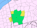
Map of the Pittsburgh-New Castle-Weirton, PA-OH-WV Combined Statistical Area (CSA)
-
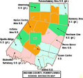
Map of Indiana County, Pennsylvania Public School Districts
-
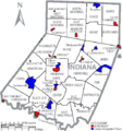
Map of Indiana County, Pennsylvania with Municipal Labels showing Boroughs (red), Townships (white), and Census-designated places (blue).


See also
 In Spanish: Condado de Indiana para niños
