Mahaffey, Pennsylvania facts for kids
Quick facts for kids
Mahaffey, Pennsylvania
|
|
|---|---|
|
Borough
|
|

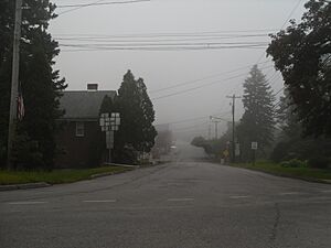
Southbound PA 36 (Market Street) from US 219
|
|

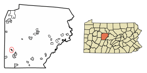
Location of Mahaffey in Clearfield County, Pennsylvania.
|
|

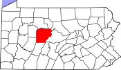
Location of Clearfield County in Pennsylvania
|
|
| Country | United States |
| State | Pennsylvania |
| County | Clearfield |
| Settled | 1841 |
| Incorporated | 1889 |
| Government | |
| • Type | Borough Council |
| Area | |
| • Total | 0.44 sq mi (1.13 km2) |
| • Land | 0.43 sq mi (1.11 km2) |
| • Water | 0.01 sq mi (0.02 km2) |
| Elevation | 1,320 ft (400 m) |
| Population
(2020)
|
|
| • Total | 329 |
| • Density | 768.69/sq mi (296.72/km2) |
| Time zone | UTC-5 (Eastern (EST)) |
| • Summer (DST) | UTC-4 (EDT) |
| ZIP code |
15757
|
| Area code(s) | 814 |
| FIPS code | 42-46568 |
Mahaffey is a small town, called a borough, located in Clearfield County, Pennsylvania, United States. In 2020, about 329 people lived there. The town is served by U.S. Route 219, a main road that helps people travel through the area.
Contents
History of Mahaffey
Mahaffey was started in 1841 by a person named Robert Mahaffey. It was built where Chest Creek flows into the West Branch Susquehanna River. This was a good spot for a settlement because of the water.
When it was first founded, the town was called "Franklin". It officially became a borough in 1841. Back then, it had important places like a public school, four churches, a grist mill (which grinds grain), and a tannery (where animal hides are made into leather).
Mahaffey also became an important meeting point for trains. The New York Central & Hudson River Railroad and the Pennsylvania & Northwestern Railroad both had lines that met there. This helped the town grow and connect with other places.
Geography and Location
Mahaffey is found in the southwestern part of Clearfield County. It's located at 40°52′33″N 78°43′41″W / 40.875779°N 78.728108°W. U.S. Route 219 goes right through the borough. This road leads about 11 miles northeast to Grampian and about 8 miles southwest to Burnside.
The United States Census Bureau says that Mahaffey covers a total area of about 0.44 square miles (1.13 square kilometers). Most of this area, about 0.43 square miles (1.11 square kilometers), is land. A very small part, about 0.01 square miles (0.02 square kilometers), is water.
Population Over Time
| Historical population | |||
|---|---|---|---|
| Census | Pop. | %± | |
| 1890 | 627 | — | |
| 1900 | 741 | 18.2% | |
| 1910 | 754 | 1.8% | |
| 1920 | 801 | 6.2% | |
| 1930 | 667 | −16.7% | |
| 1940 | 609 | −8.7% | |
| 1950 | 646 | 6.1% | |
| 1960 | 582 | −9.9% | |
| 1970 | 482 | −17.2% | |
| 1980 | 513 | 6.4% | |
| 1990 | 341 | −33.5% | |
| 2000 | 402 | 17.9% | |
| 2010 | 368 | −8.5% | |
| 2020 | 329 | −10.6% | |
| 2021 (est.) | 323 | −12.2% | |
| Sources: | |||
In 2000, there were 402 people living in Mahaffey. The population has changed over the years, as you can see in the chart above. In 2020, the population was 329 people.
Fun Things to Do
North of Mahaffey, you can find Mahaffey Camp. This is a special camp and conference center that is part of the Christian and Missionary Alliance church group.
Another interesting place is the McGees Mills Covered Bridge. It's located west of Mahaffey on U.S. Route 219. This bridge is one of the few old covered bridges left in Pennsylvania. It's so special that it's listed on the National Register of Historic Places. This means it's an important historical site.
Schools in the Area
The children in Mahaffey go to schools that are part of the Purchase Line School District.
Famous People from Mahaffey
- Melvin L. Brown: He was awarded a Medal of Honor for his brave actions during the Korean War. The Medal of Honor is the highest award a person can receive for military bravery in the United States.
See also
 In Spanish: Mahaffey para niños
 | Kyle Baker |
 | Joseph Yoakum |
 | Laura Wheeler Waring |
 | Henry Ossawa Tanner |


