Chillisquaque Creek facts for kids
Quick facts for kids Chillisquaque Creek |
|
|---|---|

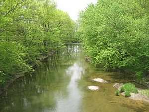
Chillisquaque Creek looking downstream above Washingtonville
|
|
| Other name(s) | Chilisquaque Creek |
| Physical characteristics | |
| Main source | confluence of Middle Branch Chillisquaque Creek and East Branch Chillisquaque Creek in Derry Township, Montour County, Pennsylvania 520 ft (160 m) |
| River mouth | West Branch Susquehanna River in West Chillisquaque Township, Northumberland County, Pennsylvania 430 ft (130 m) 40°55′59″N 76°51′37″W / 40.93306°N 76.86020°W |
| Length | 20.2 mi (32.5 km) |
| Basin features | |
| Progression | West Branch Susquehanna River → Susquehanna River → Chesapeake Bay |
| Basin size | 112 sq mi (290 km2) |
| Tributaries | |
Chillisquaque Creek is a stream that flows into the West Branch Susquehanna River. It runs through Montour County and Northumberland County in Pennsylvania, USA. The creek is about 20.2 miles (32.5 km) long.
It flows through several towns and townships. These include Derry Township, Washingtonville, and Liberty Township in Montour County. It also goes through East Chillisquaque Township and West Chillisquaque Township in Northumberland County.
The area of land that drains into the creek, called its watershed, is 112 square miles (290 km2). Sadly, farming activities have caused many streams in this area to be polluted. This pollution includes too much dirt and changes to the natural habitats.
The amount of water flowing in the creek changes throughout the year. Between 1980 and 2014, the average flow ranged from 48.2 to 146.0 cubic feet per second (1.36 to 4.13 m3/s). The land around the creek is mostly rolling farmland. The creek's path cuts through rocks like sandstone and shale. Chillisquaque Creek is known as a warmwater stream.
The creek's watershed covers parts of four counties: Columbia, Montour, Northumberland, and Lycoming. There's a special station near Washingtonville that measures the creek's flow. Long ago, a Shawnee village was located where the creek meets the West Branch Susquehanna River. A fort called Fort Bosley also used to be near Washingtonville.
Many bridges were built over the creek over the years. Two of these bridges are so old and important that they are listed on the National Register of Historic Places. The creek is a good place for fishing, especially for warmwater fish. It's also a place where fish travel to lay their eggs.
A special natural area, the Chillisquaque Creek Natural Area, is found along the creek. Bucknell University owns this land. Many different birds and wildflowers can be seen near the creek. People can enjoy canoeing and fishing in the watershed.
Contents
The Creek's Journey
Chillisquaque Creek starts where two smaller streams meet. These are East Branch Chillisquaque Creek and Middle Branch Chillisquaque Creek. This meeting point is in Derry Township, Montour County.
The creek first flows west-southwest, then turns south-southwest. It soon turns west and gets water from West Branch Chillisquaque Creek. Then, it flows south-southeast, following Pennsylvania Route 54. It crosses this road once.
The creek flows past Washingtonville and crosses Pennsylvania Route 254. Here, it receives Mud Creek from its left side. After this, the creek generally flows west-southwest and enters Liberty Township.
In Liberty Township, the creek flows through a wide valley. Limestone Ridge is to its north. Many small, unnamed streams join the creek here. After several miles, the creek leaves the valley and goes under Interstate 80. It then leaves Liberty Township and Montour County.
When it leaves Montour County, the creek enters East Chillisquaque Township, Northumberland County. It flows south-southeast, near the county line, and crosses Pennsylvania Route 642. Here, it gets water from Beaver Run, its last named tributary.
The creek then turns southwest, then south, and then west. It crosses Pennsylvania Route 45 and winds its way southwest. It flows along the border between East Chillisquaque Township and West Chillisquaque Township. It passes the Rishel Covered Bridge while still on the border.
Finally, the creek turns west-southwest and enters West Chillisquaque Township. It flows through a valley between Montour Ridge and a smaller hill. After leaving this valley, it crosses Pennsylvania Route 147 and Pennsylvania Route 405. It then flows southwest for a short distance before joining the West Branch Susquehanna River.
Chillisquaque Creek meets the West Branch Susquehanna River about 5.01 miles (8.06 km) upstream from the river's mouth.
Creek Branches
Chillisquaque Creek has five main branches that feed into it. These are Beaver Run, Mud Creek, West Branch Chillisquaque Creek, East Branch Chillisquaque Creek, and Middle Branch Chillisquaque Creek.
- Beaver Run joins the creek about 7.80 miles (12.55 km) from its mouth. Its watershed covers 12.0 square miles (31 km2).
- Mud Creek joins about 16.79 miles (27.02 km) from the mouth. Its watershed is 17.7 square miles (46 km2).
- West Branch Chillisquaque Creek joins about 18.26 miles (29.39 km) from the mouth.
- East Branch Chillisquaque Creek and Middle Branch Chillisquaque Creek both join about 19.96 miles (32.12 km) from the mouth. Their watersheds are 9.75 square miles (25.3 km2) and 9.64 square miles (25.0 km2) respectively.
Water Quality
Parts of Chillisquaque Creek are considered "impaired," meaning the water quality isn't as good as it should be. The main problems are too much dirt (sedimentation) and changes to the natural environment. These issues mostly come from agriculture and some industrial sources.
Heavy farming in the area affects the creek's water quality. About 83% of all the streams in the watershed, which is 215 miles (346 km), are impaired. In the 1980s, pollution levels in the creek were generally low. Even though a nearby power plant added some things to the water, the levels were still safe for most pollutants.
The amount of water flowing in the creek changes a lot each year. The highest average flow between 1980 and 2014 was 146.0 cubic feet per second (4.13 m3/s) in 2011. The lowest average flow was 48.2 cubic feet per second (1.36 m3/s) in 2001. The months with the most water flow are March, April, and December.
Measurements in the 1970s showed the creek's pH (how acidic or basic the water is) was between 6.3 and 7.1. This is a fairly neutral range. The water's clarity (turbidity) was also measured. The amount of dissolved oxygen, which fish need to breathe, was good, ranging from 9.0 to 11.0 milligrams per liter.
Land and Climate
The land around the mouth of Chillisquaque Creek is about 430 feet (130 m) above sea level. Where the creek starts, it's about 520 feet (160 m) above sea level. This means the creek drops about 3 feet per mile (0.57 m/km) as it flows.
The upper parts of the creek's watershed are in the Muncy Hills. Montour Ridge is to the south, and Limestone Ridge is also nearby. The area around the creek is mostly rolling farmland. There are also some forested areas along the creek's banks.
Many parts of Montour County are in the creek's 100-year floodplain. This means these areas could flood once every 100 years on average. The creek usually flows calmly, but it has some rocky, shallow areas called riffles and gravel bars. It's generally 20 and 30 feet (6.1 and 9.1 m) wide.
The creek flows through a wide, flat valley. This valley is about 2 to 3 miles (3.2 to 4.8 km) wide. The creek's path is winding and goes through rock formations made of sandstone and shale. Other types of rocks like limestone and chert are also found nearby.
In the early 1900s, the area around Chillisquaque Creek received about 35 to 45 inches (89 to 114 cm) of rain each year. The creek's water is generally warm.
Creek's Surroundings
The entire area that drains into Chillisquaque Creek, its watershed, covers 112 square miles (290 km2). The creek's mouth is in the Northumberland map area, and its source is in the Washingtonville map area. The creek also flows through the Milton map area. You can reach the creek from several state roads, including Pennsylvania Route 45, 405, and 642.
The watershed of Chillisquaque Creek is in parts of four counties: Montour, Northumberland, Columbia, and Lycoming. It's the largest watershed in Montour County, covering 56% of its land. It's also the only big stream in northern Northumberland County. There are about 260 miles (420 km) of streams in the whole watershed.
Most of the land along Chillisquaque Creek is used for farming. In the 1980s, the main crops grown were corn and soybeans.
There's a special station at Washingtonville that measures the creek's water flow. Upstream from this point, the watershed covers 51.3 square miles (133 km2). A lake called Lake Chillisquaque is on the Middle Branch Chillisquaque Creek. It's the biggest lake in Montour County, covering 165 acres (67 ha). There are two dams in the watershed, both built in 1971.
Creek's Past
Chillisquaque Creek was officially named in the Geographic Names Information System on August 2, 1979. It's also sometimes called Chilisquaque Creek. Its name probably comes from a Shawnee word, chilisuagi, which might mean "place of the snow-birds." Other ideas for the name's meaning include "flight of the wild goose" or "frozen duck."
Long ago, the Shawnee Native Americans had a large village at the mouth of Chillisquaque Creek. This village was there by 1728 and was known as Chenastry or Otzinachson. The Shawnees living on the creek moved to Western Pennsylvania in 1728. A Mingo chief named Logan lived near the creek's mouth around 1753.
A frontier fort, Fort Rice, used to be located on Chillisquaque Creek near what is now Washingtonville. In 1791, a mill was built at the creek's mouth. The first Methodist religious meeting in the area was held near the creek in August 1806. In the 1820s, the creek was declared a public highway, meaning it could be used for travel.
In the early 1900s, farming and clay mines were the main businesses in the creek's area. The creek's water power also ran several small mills. Railroads like the Susquehanna, Bloomsburg, and Berwick Railroad also passed through the watershed. Some major communities along the creek included Exchange, Jerseytown, Potts Grove, and Washingtonville.
Many bridges have been built over Chillisquaque Creek over the years. The Washingtonville Bridge was built in 1887. The Rishel Covered Bridge, built in 1830, and the Gottlieb Brown Covered Bridge, built in 1881, are both listed on the National Register of Historic Places. These old bridges show the history of the area.
Wildlife and Plants
The area around Chillisquaque Creek is a good place for warmwater fish and for fish that travel to lay eggs. While you won't find trout here, the creek has many other fish species. In 1934, it was stocked with black bass, sunfish, and yellow perch. Smallmouth bass are also common in the creek.
There's a special forested area called the Chillisquaque Creek Natural Area in Liberty Township. It's also known as the Bucknell Preserve. This area has a forest with pools and channels along the creek. Bucknell University owns this land, and its students often study the many different trees found there. Common trees include basswood, bitternut hickory, pin oak, and shagbark hickory.
You can also find cat-tail sedges and marshes dominated by cattails, grasses, and sedges near the creek. Planting more native trees along the creek would help improve the water quality. In April, you can see beautiful woodland wildflowers like bluebells, Virginia cowslip, and mint.
Many bird species live at the Bucknell Preserve, including marsh wrens and soras. Virginia rails have also been seen there. Several types of mussels, which need very clean water to survive, have been found in the creek.
Fun Activities
You can go canoeing on at least 17.9 miles (28.8 km) of Chillisquaque Creek. This stretch goes from Pennsylvania Route 54 at Washingtonville down to where the creek meets the river. The creek is easy for beginners to canoe on. It's usually best for canoeing from March to May, unless it's a very dry year.
A plan has been suggested to create a greenway along Chillisquaque Creek. This would be a nice path for walking or biking. You can also go fishing and boating on Lake Chillisquaque, but only non-powered or electric boats are allowed. The best time to fish in the creek is in the spring.
There's a campsite called Shangri-La on the Creek, located at the base of Montour Ridge. It has many campsites right by the creek and others in forested areas. At the campsite, you can go fishing and play Frisbee golf.
Chillisquaque Creek was once considered for a special "Pennsylvania Scenic Rivers" designation.
 | Madam C. J. Walker |
 | Janet Emerson Bashen |
 | Annie Turnbo Malone |
 | Maggie L. Walker |


