East Branch Chillisquaque Creek facts for kids
Quick facts for kids East Branch Chillisquaque Creek |
|
|---|---|

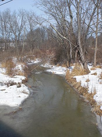
East Branch Chillisquaque Creek about 2 miles (3.2 km) downstream of its headwaters
|
|
| Physical characteristics | |
| Main source | Pennsylvania State Game Lands Number 226 in Madison Township, Columbia County, Pennsylvania |
| River mouth | Chillisquaque Creek in Derry Township, Montour County, Pennsylvania 522 ft (159 m) 41°04′55″N 76°39′53″W / 41.08205°N 76.66476°W |
| Length | 6.2 mi (10.0 km) |
| Basin features | |
| Progression | Chillisquaque Creek → West Branch Susquehanna River → Susquehanna River → Chesapeake Bay |
| Basin size | 9.75 sq mi (25.3 km2) |
| Tributaries |
|
The East Branch Chillisquaque Creek is a cool stream in Pennsylvania, United States. It flows through Columbia County and Montour County. This creek is about 6.2 miles (10.0 km) long. It eventually joins the Middle Branch Chillisquaque Creek to form the main Chillisquaque Creek.
The name Chillisquaque comes from a Native American word. It might mean "a place where snowbirds visit often" or "frozen duck." The land around the creek is mostly forests and farms. However, the creek faces a challenge: siltation, which means too much dirt and mud are in the water. Because of this, the water quality isn't as good as it should be.
Contents
Exploring the East Branch Chillisquaque Creek's Path
The East Branch Chillisquaque Creek starts in northern Madison Township. Its very beginning, called the headwaters, is in a special protected area called Pennsylvania State Game Lands Number 226. This spot is on the southern side of the Muncy Hills.
The creek first flows south through a valley. Soon, it leaves the game lands and continues south. It then crosses Pennsylvania Route 44 and turns southwest, leaving Madison Township.
Journey Through Montour County
After leaving Columbia County, the creek enters northern Derry Township in Montour County. Here, it turns west and flows near a place called Strawberry Ridge. In the middle of the township, the creek meets its only named smaller stream, White Hall Creek.
The East Branch Chillisquaque Creek then keeps flowing west. It passes a special station that measures its water flow and a power plant. Not long after, it meets the Middle Branch Chillisquaque Creek. When these two branches join, they officially become the main Chillisquaque Creek. The mouth, or end, of the East Branch is near the northern border of Derry Township.
White Hall Creek: A Tributary
White Hall Creek is the only named stream that flows into the East Branch Chillisquaque Creek. It travels south through Anthony Township before joining the East Branch in Derry Township. White Hall Creek adds its water to the main creek about 0.94 miles (1.51 km) before the East Branch ends. Its own watershed, or the area of land that drains into it, is about 2.31 square miles (6.0 km2).
Water Flow and Health of the Creek
The study of how water moves and behaves is called hydrology. The East Branch Chillisquaque Creek has an average water flow, or discharge, of about 9.66 cubic feet per second. This is measured at a special station along the creek.
Unfortunately, the creek has a problem with siltation. This means that too much sediment (like dirt, sand, and mud) is getting into the water. This can make the water cloudy and harm the plants and animals that live there. Because of this, the creek's water quality doesn't meet the standards set by the Pennsylvania Department of Environmental Protection. This means it needs help to become healthier.
Land and Rocks Around the Creek
The land around the East Branch Chillisquaque Creek is made up of different kinds of rocks. You can find sandstone and shale. Some of the shale near the creek in Montour County is very old, from a time called the Devonian period. There are also areas with limestone that are about 30 to 40 feet (9.1 to 12.2 m) thick.
These limestone beds are special because they contain fossils! Scientists have found fossils of ancient sea creatures like Ambrocoelia umbonata, Spirifira zicac, and Atrypa reticularis. They've also found two types of fossilized trilobites, which were ancient sea bugs: Dalmanites calliteles and Phacops rana.
The creek's elevation, or how high it is above sea level, is about 530 feet (160 m) at the measuring station. At its mouth, where it joins the Middle Branch, the elevation is 522 feet (159 m).
Creek Banks and Erosion
Along the East Branch Chillisquaque Creek, especially between Pennsylvania Route 44 and where it joins the Middle Branch, there are many spots where the creek banks show signs of wear and tear. Most of these spots are places where the soil is eroding, meaning it's washing away. This adds to the siltation problem in the creek.
The creek has many different stream banks. Some are short, less than 50 feet (15 m) long, and most are not very high. Others are longer, up to 250 feet (76 m) or more. A few of these longer banks can be quite high. Besides erosion, you might also see gravel bars (piles of rocks and pebbles), bridges, and pipes along the creek.
The Creek's Watershed
The watershed of the East Branch Chillisquaque Creek is the entire area of land where all the rain and snow eventually drain into this creek. This watershed covers about 9.75 square miles (25.3 km2). It includes parts of both Montour County and Columbia County. There are about 18.38 miles (29.58 km) of streams flowing within this watershed.
Most of the land in the watershed is used for farming (about 57.1 percent) or is covered by forests (about 41.8 percent). The forests are mostly in the higher parts of the watershed. There are also some wetlands and open water areas, especially near the border between the two counties. Some residential areas, where people live, are also found along the creek. The land under the creek itself is owned by the public.
History of the East Branch Chillisquaque Creek
The area around the upper parts of the East Branch Chillisquaque Creek was first settled by Europeans in 1775. Two people from New Jersey, Daniel Welliver and Michael Billhiemer, were among the first to make their homes there.
A special kind of pony truss bridge was built over the lower part of the creek in 1909. This bridge is 49.9 feet (15.2 m) long and is still used by cars today!
As mentioned earlier, the name chillisquaque has a cool meaning. It comes from a Native American word that either describes a "place frequented by snowbirds" or means "frozen duck."
 | William L. Dawson |
 | W. E. B. Du Bois |
 | Harry Belafonte |


