White Hall Creek facts for kids
Quick facts for kids White Hall Creek |
|
|---|---|

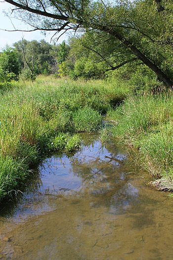
White Hall Creek looking downstream
|
|
| Physical characteristics | |
| Main source | base of a hill in Madison Township, Columbia County, Pennsylvania between 900 and 920 feet (270 and 280 m) |
| River mouth | East Branch Chillisquaque Creek in Derry Township, Montour County, Pennsylvania 545 ft (166 m) 41°05′02″N 76°38′59″W / 41.08382°N 76.64975°W |
| Length | 3.8 mi (6.1 km) |
| Basin features | |
| Progression | East Branch Chillisquaque Creek → Chillisquaque Creek → West Branch Susquehanna River → Susquehanna River → Chesapeake Bay |
| Basin size | 2.31 sq mi (6.0 km2) |
| Tributaries |
|
White Hall Creek is a small stream, also called a tributary, that flows into the East Branch Chillisquaque Creek. You can find it in Columbia County and Montour County, in the state of Pennsylvania, USA. This creek is about 3.8 miles (6.1 km) long. It winds its way through different areas like Madison Township, Anthony Township, and Derry Township.
The land area that drains water into White Hall Creek, called its watershed, covers about 2.31 square miles (6.0 km2). Sadly, all the streams in this area have water quality problems, mainly because of dirt and mud (called siltation) from nearby farms. Even so, White Hall Creek is a good place for fish that like warmer water.
Contents
Where White Hall Creek Flows
White Hall Creek starts at the bottom of a hill in Madison Township, which is in Columbia County. It first flows towards the south-southwest for a short distance. Then, it changes direction and heads south-southeast for a little while.
After that, the creek turns south-southwest again for about half a mile. During this part of its journey, it leaves Columbia County.
Once it leaves Columbia County, White Hall Creek enters Anthony Township in Montour County. It continues flowing south-southwest for several tenths of a mile. Along this path, it crosses Pennsylvania Route 44. It also picks up water from a small, unnamed stream joining it from the left side.
The creek then turns west-southwest for a short distance. Here, another unnamed stream adds its water from the left. After this, White Hall Creek turns south. Further downstream, it gets water from a third unnamed stream, also from the left. A bit more downstream, it turns west-southwest one last time. Soon after, it meets and joins the East Branch Chillisquaque Creek.
White Hall Creek joins the East Branch Chillisquaque Creek about 0.94 miles (1.51 km) before the East Branch reaches its own end.
Water Quality of the Creek
All the streams in the White Hall Creek watershed, including the creek itself, are listed as having water quality issues. The main problem is siltation, which means there's too much dirt and mud in the water. This siltation mostly comes from farming activities in the area.
Land and Landscape Around the Creek
The land where White Hall Creek ends, called its mouth, is about 545 feet (166 m) above sea level. Where the creek begins, its source, the land is higher, between 900 and 920 feet (270 and 280 m) above sea level.
Creek's Surroundings and Wildlife
The entire area that drains water into White Hall Creek is called its watershed, and it covers about 2.31 square miles (6.0 km2). The mouth of the creek is located in a map area known as the Washingtonville quadrangle. However, the creek's source is in the Hugesville quadrangle, and it also flows through the Millville quadrangle. In total, there are about 5.43 miles (8.74 km) of streams within this watershed.
White Hall Creek is known as a Warmwater Fishery, meaning it's a good home for fish that prefer warmer water. To make the water even better, adding more riparian buffers along the creek would help. These are strips of plants and trees along the banks that filter out pollution and keep the soil in place.
History of White Hall Creek
White Hall Creek was officially added to the Geographic Names Information System on August 2, 1979. This system keeps track of names and locations of places in the United States. Its special ID number there is 1191276.
A bridge that carried Preserve Road over White Hall Creek was built in 1937. It was 17 feet (5.2 m) long and was located about 3.5 miles (5.6 km) east of Pennsylvania Route 54 in Anthony Township, Montour County. However, by 2012, a road crew from the Pennsylvania Department of Transportation replaced this old bridge. They put in a new precast concrete box culvert, which is like a large concrete pipe or tunnel.
White Hall Creek was first listed as having water quality problems in 1998. The plan to fix these problems, called a total maximum daily load (TMDL), was set for 2011.
 | Leon Lynch |
 | Milton P. Webster |
 | Ferdinand Smith |


