
West Branch Chillisquaque Creek facts for kids
Quick facts for kids West Branch Chillisquaque Creek |
|
|---|---|

West Branch Chillisqaque Creek in Anthony Township, Montour County
|
|

Satellite map of West Branch Chillisquaque Creek. The red dot is the stream's source and blue dot is its mouth.
|
|
| Physical characteristics | |
| Main source | Columbia County, Pennsylvania |
| River mouth | Chillisquaque Creek 41°03′57″N 76°40′49″W / 41.06594°N 76.68030°W |
| Length | 5 mi (8.0 km) |
| Basin features | |
| Tributaries |
|
West Branch Chillisquaque Creek is a small river, also called a tributary, that flows into Chillisquaque Creek. Its watershed is the area of land where all the rain and snow melt drains into the creek. This watershed covers parts of Northumberland, Montour, Lycoming, and Columbia counties in Pennsylvania. West Branch Chillisquaque Creek is about 5 mi (8.0 km) long. Many different trees and plants grow along its banks. The land around the creek also has five main types of rock and four main types of soil.
Contents
Where Does the Creek Flow?

West Branch Chillisquaque Creek is about five to six miles (8.0 to 9.7 km) long. It begins a little east of Anthony Township. From there, it flows west. The creek then turns southwest for a while. After that, it flows almost straight south. It passes under Pennsylvania Route 44 as it goes through the town of Exchange.
The creek gets its only named smaller stream, called County Line Branch, right where it joins Chillisquaque Creek. West Branch Chillisquaque Creek then empties into Chillisquaque Creek near Washingtonville.
What is the Land Like Around the Creek?
The area around West Branch Chillisquaque Creek is part of the Ridge-and-Valley Appalachians. This means it has many long, parallel ridges and valleys. The place where the creek starts, called its headwaters, is 750 feet (230 m) higher than where it ends, called its mouth. The highest part of the watershed is in the northeast.
Rocks and Soil in the Watershed
Most of the upper part of the creek's watershed has sedimentary rock. This kind of rock forms from layers of sand, mud, and tiny bits of plants and animals over a long time. Common rock types here include the Hamilton Group and the Trimmers Rock. Other rocks are mostly shale and carbonate minerals, like the Keyser/Tonoloway formation.
The Hamilton Group rocks are mostly found in the middle of the watershed. The Trimmers Rock is in the northern part.
There are also several types of soil in the watershed. Most of these soils are silt loams. Silt loam is a type of soil that feels smooth and powdery when dry. These soils include the Watson-Berks-Elvira soil and the Berks-Weikert-Bedington soil. There is also a different type of soil called Chenango-Pope-Holly soil.
The Watson-Berks-Elvira soil is mostly in the middle of the watershed. The Berks-Weikert-Bedington soil is mainly in the northern part. The Chenango-Pope-Holly soil is in a small area in the southeast. The soil near the creek's beginning is very fertile, which means it's good for growing plants.
Sometimes, livestock like cows graze near the creek. This can cause the creek's banks to wear away, a process called erosion.
How Clean is the Creek's Water?
About 20,759 pounds (9,416 kg) of sediment (tiny bits of dirt and rock) and 21.2635 pounds (9.6450 kg) of phosphorus (a nutrient) flow through the creek's watershed every day. Luckily, there is no point-source pollution. This means no single pipe or drain is dumping pollution directly into the creek. West Branch Chillisquaque Creek is similar to Roaring Creek in how much rain and snow falls in its area.
What is the Creek's Watershed Like?
The watershed of West Branch Chillisquaque Creek covers an area of 33.2 square miles (86 km2). You can reach the creek and its smaller streams using local roads. You can also get there by Pennsylvania Route 44 and Pennsylvania Route 54.
The creek has several tributaries, including County Line Branch and Beaver Run. There are also many smaller streams that don't have names.
Land Use in the Watershed
The land in the watershed is used in different ways:
- 58% is agricultural areas, meaning farms.
- 36% is forest, covered in trees.
- 6% is developed areas, like towns and buildings.
The forests are mostly in the northern part of the watershed. The farms are mainly in the southern and central parts. The developed areas are small sections in the eastern part of the watershed.
A Look at the Creek's History
The name 'Chillisquaque' comes from a Native American word. It means a place where snowbirds often visit. In 2010, West Branch Chillisquaque Creek was part of a project to help restore its natural health.
Plants and Animals Around the Creek
Some parts of the creek have 91.15 miles (146.69 km) of streams with too much organic material, sediment from farms, and low levels of dissolved oxygen. Dissolved oxygen is important for fish and other water creatures to breathe.
Where the creek flows past farms, the natural area along its banks, called the riparian buffer, is not doing well. This buffer of plants helps protect the creek. However, near the creek's beginning, there are northern hardwood trees and hemlock forests. You can also find many wild leeks and other spring flowers there. These trees and plants act like a natural shield for the creek.
Common Species in the Watershed
There are 12 common types of trees in the watershed of West Branch Chillisquaque Creek. You can also find 22 common types of herbs, which are plants with soft stems.
Many different birds live here too. The main bird species include Ovenbirds, black-throated green warblers, wood thrushes, blue-headed vireos, and common yellowheads.
Images for kids
-
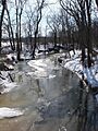
West Branch Chillisqaque Creek in Anthony Township, Montour County
-
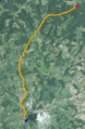
Satellite map of West Branch Chillisquaque Creek. The red dot is the stream's source and blue dot is its mouth.
-
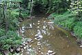
West Branch Chillisquaque Creek in the summer
