Mud Creek (Chillisquaque Creek tributary) facts for kids
Quick facts for kids Mud Creek |
|
|---|---|

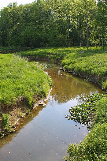
Mud Creek looking downstream in Derry Township
|
|
| Physical characteristics | |
| Main source | Madison Township, Columbia County, Pennsylvania 760 ft (230 m) |
| River mouth | Chillisquaque Creek in Derry Township, Montour County, Pennsylvania 502 ft (153 m) 41°02′48″N 76°40′33″W / 41.04673°N 76.67570°W |
| Length | 8.3 mi (13.4 km) |
| Basin features | |
| Progression | Chillisquaque Creek → West Branch Susquehanna River → Susquehanna River → Chesapeake Bay |
| Basin size | 17.70 sq mi (45.8 km2) |
Mud Creek is a small stream in Columbia County and Montour County, Pennsylvania. It flows into Chillisquaque Creek. The creek is about 8.3 miles (13.4 kilometers) long. It flows through Madison Township in Columbia County and Derry Township in Montour County.
Mud Creek gets its name because its water often looks muddy, especially after storms. The area around the creek was settled a long time ago, in 1772. Several bridges were built over it in the 1900s. Mud Creek is known as a good place for warm-water fish.
The land around the creek, called its watershed, covers 17.70 square miles (45.8 square kilometers). This area is mostly farms and forests. The main towns in the watershed are Washingtonville and Jerseytown.
| Top - 0-9 A B C D E F G H I J K L M N O P Q R S T U V W X Y Z |
Where Mud Creek Flows
Mud Creek starts in the middle of Madison Township, Columbia County. It first flows south for a short distance. Then, it turns southwest and goes through Jerseytown. In Jerseytown, it crosses Pennsylvania Route 44.
The creek keeps flowing southwest, running next to Pennsylvania Route 254. Over the next few miles, its path slowly changes from southwest to west. It then leaves Madison Township and enters Derry Township, Montour County.
Mud Creek turns southwest again, still following Pennsylvania Route 254. Along the way, it gets water from several smaller streams that don't have names. Finally, it crosses Pennsylvania Route 54 and joins Chillisquaque Creek. This meeting point is just south of Washingtonville.
Water Quality and Health
The water in Mud Creek and its smaller streams has some problems. In 2011, scientists found that many streams in the area were not as healthy as they should be. This was due to too much organic material, low oxygen levels, and a lot of mud or dirt, called sediment.
Sediment in the Water
Sediment is tiny bits of dirt, sand, or rock that get carried by water. Too much sediment can make the water cloudy and harm fish and other water creatures. In 2011, about 24,165 pounds (10,961 kilograms) of sediment flowed through Mud Creek each day. This was much more than the healthy limit of 11,371 pounds (5,158 kilograms) per day.
Most of this sediment came from farm fields, especially croplands. Streambanks and pastures also added a lot of sediment. After heavy rainstorms, the streams in the Mud Creek area can stay muddy for several days.
Phosphorus Levels
Phosphorus is a nutrient that can cause problems in water if there's too much of it. It can make algae grow too fast, which uses up oxygen that fish need. In 2011, about 16.64 pounds (7.55 kilograms) of phosphorus flowed through Mud Creek daily. This was more than the healthy limit of 6.71 pounds (3.04 kilograms) per day.
Like sediment, most of the phosphorus came from farm fields. Groundwater and pastures also contributed to the phosphorus levels. Even septic systems, which treat wastewater, added a small amount of phosphorus to the creek.
Other Water Details
The amount of water flowing in Mud Creek changes a lot. It can be as low as 0.1 cubic feet per second or as high as 13 cubic feet per second. On average, it flows at 5.8 cubic feet per second.
Scientists also measure the water's pH, which tells us how acidic or basic the water is. Mud Creek's pH usually ranges from 6.3 to 7.9. They also check for different chemicals like bicarbonate, nitrates, sulfates, and chlorides. These measurements help them understand the water's overall health.
Much of the pollution in Mud Creek comes from "nonpoint sources." This means the pollution doesn't come from one single pipe or factory. Instead, it comes from many different places across the land, like farms or developed areas, and washes into the creek when it rains. Experts have suggested fixing this pollution to make the creek healthier.
Land and Environment
Creek's Location and Height
Mud Creek starts at an elevation of about 760 feet (232 meters) above sea level. Where it joins Chillisquaque Creek, the elevation is about 502 feet (153 meters). The highest parts of the land around the creek are in the southeast. The entire area is part of the ridge and valley region of the Appalachian Mountains. This means it has long, parallel ridges and valleys.
Rocks and Soil
The most common type of rock in the Mud Creek watershed is shale. You can also find siltstone and sandstone in some areas. These different rocks affect the landscape and how water flows.
The soil around Mud Creek is mostly a type called Watson-Berks-Alvira series. This is a shaly silt loam, which is a mix of sand, silt, and clay. Other types of soil are found closer to the creek and along the southern edge of its watershed. In the flat areas next to the creek, called the floodplain, you can find different soil types like Holly-Monogahela-Basher.
Rainfall
On average, the Mud Creek watershed gets about 44.5 inches (113 centimeters) of rain each year. A small amount of this rain, about 0.13 inches (0.33 centimeters), runs off the land into the creek each year.
Land Use and Communities
The land around Mud Creek, its watershed, covers 17.70 square miles (45.8 square kilometers). Most of this land is in Madison Township and Derry Township. A small part is also in West Hemlock Township.
Most of the land in the watershed is used for farming, making up about 63% of the area. Forests cover about 31% of the land, mostly on the southern and eastern edges. About 5.5% of the land is developed, meaning it has buildings or roads. Most of these developed areas are near Jerseytown and Washingtonville.
The main towns in the Mud Creek watershed are Jerseytown and Washingtonville. Important roads like Pennsylvania Route 254 run through the area. Many smaller township roads also lead to the creek and its tributaries.
History of the Creek
One of the first settlers in the Mud Creek valley was George Whitmoyer, who built a cabin in Jerseytown in 1772.
Over the years, many bridges have been built over Mud Creek. The Mud Creek Bridge, a type of bridge called a Pratt pony truss, was built in 1907. It is 40 feet (12 meters) long. This old bridge is now closed to traffic because it is very old and damaged. Eight other bridges also cross the creek. Four were built in the 1930s, one in 1946, two in 1962, and the newest one in 1984. Four more bridges were built over the smaller streams that feed into Mud Creek in the 1940s.
In an 1888 book about Columbia County, the writer John Gosse Freeze called Mud Creek the "East Branch of Chillisquaque Creek." However, he also said that "Mud Creek" was the more common and correct name. The creek is indeed named for its muddy appearance, especially after heavy rains.
Plants and Animals
Along parts of Mud Creek that flow through farmland, there are not many riparian buffers. These are strips of plants and trees along the banks that help filter pollution and keep the soil from washing away. Experts have suggested planting more of these buffers in Derry Township to help the creek.
North of Washingtonville, there is a special area called a wet meadow along the creek. Wet meadows are damp areas with specific types of plants. You might find different kinds of ferns, sedges, grasses, and red maple trees growing there.
Mud Creek is a "warm-water fishery." This means its waters are suitable for fish that prefer warmer temperatures, like certain types of bass or sunfish.
 | William L. Dawson |
 | W. E. B. Du Bois |
 | Harry Belafonte |


