Loyalsock Creek facts for kids
Quick facts for kids Loyalsock Creek |
|
|---|---|

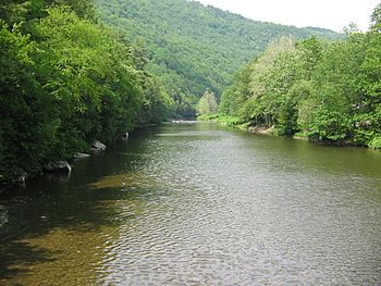
Loyalsock Creek from the Hillsgrove Covered Bridge
|
|
| Country | Pennsylvania, United States |
| Physical characteristics | |
| Main source | Western Wyoming County 2,272 feet (693 m) |
| River mouth | West Branch Susquehanna River, at Montoursville |
| Length | 64.3 miles (103.5 km) |
| Basin features | |
| Basin size | 495 square miles (1,280 km2) |
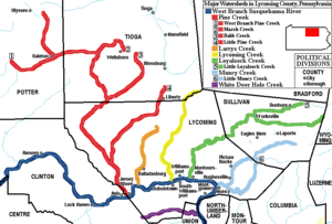
Loyalsock Creek is a 64-mile-long (103 km) tributary (a smaller stream that flows into a larger one) of the West Branch Susquehanna River. It is mostly found in Sullivan and Lycoming counties in Pennsylvania, United States. Lycoming County is about 130 miles (209 km) northwest of Philadelphia. It is also about 165 miles (266 km) east-northeast of Pittsburgh.
Contents
What's in a Name?
The name "Loyalsock" comes from the language of the Native American tribes who lived there long ago. It means "middle creek." This name makes sense because Loyalsock Creek is located between Lycoming Creek and Muncy Creek. The mouths of these creeks are about 6 miles (10 km) away from the mouth of the Loyalsock.
Many important trails used by the local Native American peoples followed parts of the Loyalsock Creek. Two important Native American villages were also located along its banks. One of these, Ots-ton-wak-in, was the home of Madame Montour and her son Andrew Montour. This village later became the town of Montoursville.
About Loyalsock Creek
Loyalsock Creek is 64.3 miles (103.5 km) long. It starts in western Wyoming County, near the border with Sullivan County. The creek then flows into the West Branch Susquehanna River at Montoursville. The area where it meets the Susquehanna River has experienced many floods, which have damaged homes and businesses.

The main stream that flows into Loyalsock Creek is called Little Loyalsock Creek. These two creeks meet at Forksville in Sullivan County. The names of Forksville and the nearby Forks Township come from this "fork" or meeting point of the creeks.
Pennsylvania gets a lot of acid rain. Loyalsock Creek flows through a region with sandstone, shale, and coal mountains. This means the creek's water cannot easily neutralize (or balance out) the added acid. This makes the creek very sensitive to acid rain, which can harm the plants and animals living in it over time.
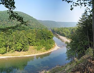
Loyalsock Creek is a popular spot for outdoor activities. People enjoy trout fishing and whitewater kayaking here. The Loyalsock Trail runs along the creek, offering great opportunities for hiking. Worlds End State Park is also located on the Loyalsock in Sullivan County, near Forksville. Pennsylvania Route 87 follows the creek's valley for much of its length.
Major Floods
Loyalsock Creek has flooded many times throughout history. Some of the biggest floods happened in 1866, 1889, 1894, and 1936. More recently, floods in 1972, 1975, 1996, and 2011 set new records for how much water flowed and how high the river rose.
Large storms like hurricanes and tropical storms are the main cause of these floods. Examples include Lee (2011), Ivan (2004), Agnes (1972), and Eloise (1975). The second largest flood, in January 1996, happened because of heavy rain and a lot of melting snow.
The record-breaking flood on September 8, 2011, was caused by several unusual events happening at once:
- Very heavy rains fell during August that year.
- Hurricane Irene brought three to five inches of rain on August 28.
- The remains of Tropical Storm Lee caused extreme rains (more than 7 inches) far upstream.
- More rain fell on September 7–8 due to moisture from Hurricane Katia.
The Loyalsock valley is deep and narrow. Water from a large area (435 square miles) funnels into this narrow valley. This causes the water level to rise very quickly and dangerously. The floods in 1996 and 2011 caused millions of dollars in damage.
The Haystacks
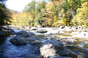
The Haystacks are unique rock formations found in Loyalsock Creek. They are mounds of sandstone that stick out of the creek south of Dushore in Sullivan County. These rocks are part of a geological layer called the Upper Huntley Mountain Formation. They were formed during the Mississippian and Devonian periods, which were millions of years ago.
History of the Loyalsock Valley
The Village of Otstonwakin
The village of Otstonwakin or Ostuagy, led by Madame Montour, was a very important place when settlers first came to what is now Lycoming County. Madame Montour ran a trading post and supply center there. The Pennsylvania Assembly even helped fund it. Her village, located where Loyalsock Creek meets the West Branch Susquehanna River (now part of Montoursville), was a key stop for Moravian missionaries. These missionaries were spreading their Christian message throughout the wilderness of Pennsylvania in the 1740s. For example, Count Zinzendorf, a missionary, visited Otstonwakin in 1742.
Madame Montour was known to be a friend of the British. She welcomed the white settlers who were moving into the West Branch Susquehanna Valley. She also had a lot of influence with different Native American tribes. Madame Montour remained loyal to the British, even though the French tried to get her to join their side. This was quite remarkable, especially since the British colonial government sometimes took a year or more to pay her for her services.
Railroads and Lumbering
Even though lumbering (cutting down trees for wood) was a big industry in the Loyalsock Creek area, railroads didn't use the creek valley much below Forksville. One exception was the Susquehanna and Eagles Mere Railroad. This line was built into Hillsgrove and along the creek as far as Ogdonia in 1902. It was removed in 1922.
Above Forksville, the Williamsport and North Branch Railroad followed Mill Creek to reach the Loyalsock. It then followed the Loyalsock to a crossing at Ringdale. This line was built in 1893 and removed in 1938.
About six miles (10 km) to the east, the town of Lopez is the largest settlement on the upper part of the creek. Jennings Brothers Lumber Co. built a narrow-gauge logging line in the area in 1890. Another line was built in 1891 up the creek into Wyoming County. These lines helped supply their sawmill at Lopez.
In 1892, the Loyalsock Railroad crossed the creek here. It was built south to bring coal from the Bernice area. This line was quickly leased to the Lehigh Valley Railroad. The Loyalsock Railroad also built a branch line along the Loyalsock downstream from Lopez to Ellis Creek. This branch was removed in 1898.
Jennings Bros. continued to operate, making their rail line wider around 1900. They built up the Loyalsock as far as Shumans Lake. The logging railroad was finally removed in 1905. However, it was partly brought back in 1911. Stony Brook Lumber Co. used the old path for a while.
Over time, traffic on the Lehigh Valley line decreased. Their line south of Lopez was abandoned in 1939. The abandonment of the line to Lopez marked the end of most train traffic on the Loyalsock. The only exception was the Reading Railroad crossing near its mouth at Montoursville. The bridge there is now owned by the Lycoming Valley Railroad. The original Reading bridge was destroyed by flooding from Tropical Storm Lee in 2011. A new replacement bridge was opened on August 13, 2014.
 | Claudette Colvin |
 | Myrlie Evers-Williams |
 | Alberta Odell Jones |


