
Great Shamokin Path facts for kids

The Great Shamokin Path was a very important trail used by Native Americans in Pennsylvania. It was like an ancient highway connecting different villages. The path started at the village of Shamokin, which is now the city of Sunbury.
From Shamokin, the trail followed the West Branch Susquehanna River. It went north and then west to a place called the Great Island, near modern-day Lock Haven. The path then left the river and continued west. It passed through Chinklacamoose, which is now Clearfield. Finally, it ended at Kittanning on the Allegheny River.
This path connected villages along the Susquehanna River with those on the Allegheny River. The Allegheny River eventually flows into the Ohio River. In the early 1700s, Shamokin and Kittanning were two of the most important Native American villages in Pennsylvania.
In 1772, a group of Moravian Christians used this path. They were led by Bishop Ettwein. About 200 Lenape and Mohican Christians traveled west. They went from their village of Friedenshütten (meaning Cabins of Peace) near Wyalusing. Their journey ended at a new village called Friedensstadt (meaning City of Peace). This new village was on the Beaver River in southwestern Pennsylvania.
Today, a 4-mile long rail trail in Armstrong County follows a small part of the Great Shamokin Path. This trail also follows the old route of the Rural Valley Railroad.
Contents
Journey Along the Path: Susquehanna to Allegheny

The village of Shamokin was located just south of where the Susquehanna River splits. This is where the West Branch Susquehanna River meets the main Susquehanna River. From Shamokin, the Great Shamokin Path went north. It crossed the river where Northumberland is today.
The path then followed the west bank of the West Branch Susquehanna River. It led to the Shawnee town of Chillisquaque. This town was on Chillisquaque Creek. The path continued north through what are now Milton and Watsontown. Here, the path split into two branches. Both branches led to Canaserage on Muncy Creek, which is now Muncy.
At Canaserage, the river and the path turned west. Other paths also branched off from here. The Wyalusing Path went northeast along Muncy Creek to Wyalusing. The Towanda Path went to Towanda. Both Wyalusing and Towanda are on the North Branch of the Susquehanna River.
The Great Shamokin Path continued west to the village of Otstonwakin. This village is now Montoursville. It was located on Loyalsock Creek where it meets the West Branch of the Susquehanna. Further upriver was French Margaret's Town. This area later became western Williamsport on Lycoming Creek. The Sheshequin Path went north along Lycoming Creek to Sheshequin, now Ulster. This town is on the North Branch Susquehanna River.
Further west, the path passed through the village of Quenashawakee. It crossed Larrys Creek and Pine Creek. Then it reached the Great Island, just east of Lock Haven.
The Great Island was a very important meeting point for many trails. The Great Shamokin Path left the river here. The river turns north at this point. The path continued west along Bald Eagle Creek. It crossed Beech Creek and followed Marsh Creek and Little Marsh Creek. Then it climbed the Allegheny Front to modern-day Snow Shoe.
From Snow Shoe, the path went to Moshannon. Here, there were two possible branches to Kylertown. These branches had different places to cross Black Moshannon Creek and Moshannon Creek. Both creeks were hard to cross. From Kylertown, the path continued west. It crossed Clearfield Creek before reaching Chinklacamoose, which is now Clearfield.
At Chinklacamoose, the Great Shamokin Path rejoined the West Branch Susquehanna River. It followed the river west for seven miles (11 km) to Curwensville, Pennsylvania and Anderson Creek. The path had to cross the Susquehanna River several times here. This was to avoid thick bushes of mountain laurel. The path followed Anderson Creek Gorge for a few miles. Then it turned west to what is now Chestnut Grove. Finally, it reached The Big Spring, near Luthersburg in Brady Township, Clearfield County, Pennsylvania.
Fort Augusta: A Historic Stronghold
Fort Augusta was a strong fort in Northumberland County, Pennsylvania. It was located in the upper Susquehanna Valley. The fort was important during the French and Indian War and the American Revolution. Colonel William Clapham built the fort in 1756. It was built in an area the Native Americans called "Shamokin". This site is now part of Sunbury.
The British first built Fort Augusta to defend against attacks from the French and Native Americans. These attacks came from the upper Allegheny region. Later, during the American Revolution, it became an American fortress. It helped protect settlers in the upper Susquehanna from Britain's Native American allies.
The fort was named after Princess Augusta of Saxe-Gotha. She was the mother of King George III. Fort Augusta was the largest of the forts built by the Pennsylvania colony. It was taken down in 1794 after the United States became independent.
During the French and Indian War in 1757–1758, hundreds of French and Native American troops used the Great Shamokin Path. They planned to destroy Fort Augusta. This army gathered from French forts like Duquesne, Kittanning, Venango, and Le Boeuf. They met at the mouth of Anderson Creek.
They built simple boats, rafts, and bateau to travel down the Susquehanna River. They even brought two small brass cannons. But after looking at the fort, they realized it was too far away for their cannons to reach. The defenses at Fort Augusta were too strong for a direct attack. So, the French attack was called off. If the British had lost Fort Augusta, it might have changed the course of the French and Indian War.
Today, the Northumberland County Historical Society has its headquarters at the site of the old fort. It is in the "Hunter House Museum." The museum has historical items and artifacts from Fort Augusta. It also has items about local history. The museum is located at 1150 North Front Street in Sunbury, Pennsylvania. Fort Augusta's underground powder magazine still exists today.
-
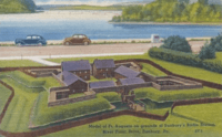
Model of Ft. Augusta, 1939
-
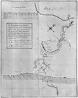
George Washington's map of French forts along the Allegheny River. French and Native American troops gathered at Anderson Creek before planning to attack Fort Augusta.


Big Spring: A Key Meeting Point

The Big Spring near Luthersburg, Brady Township, Clearfield County, Pennsylvania, was an important camp and trail center. Here, the Goschgoschink Path turned northwest. This path later became known as Mead's Path. It led to the Venango Path, Lake Erie, and even Canada.
The Great Shamokin Path continued through Troutville. It followed smaller streams that flow into Mahoning Creek. This led to Punxsutawney. From Punxsutawney, the trail followed Cowanshannock Creek to Smicksburg. It then went to Rural Valley, Kittanning, and the Allegheny River.
During the War of 1812, Major William McCelland led troops along this path. On March 4, 1814, he left Fort Loudoun near Chambersburg, Pennsylvania. His group had 221 soldiers, three captains, five lieutenants, and two ensigns. They marched along Anderson Creek to meet the Goschgoschink Path at the Big Spring. McClelland's group helped American forces at Lake Erie. They also fought bravely at the Battle of Chippewa and Battle of Lundy's Lane.
Amish Communities Along the Path

An Amish heritage area generally follows the Great Shamokin Path. This area goes through Clearfield, Jefferson, Indiana, and Armstrong counties. It starts at Big Spring near Luthersburg, Clearfield County. It ends in Rural Valley in Armstrong County.
The area winds through Amish settlements. These are near villages like Troutville in Clearfield County. Also, Big Run, Cloe, and Punxsutawney in Jefferson County. You'll find them in Smicksburg in Indiana County, and Rural Valley in Armstrong County. Amish buggies share the roads with cars in this area.
The Troutville Amish settlement in Brady Township, Clearfield County, is quite large. It has eight congregations. The settlement has farms, businesses, and small shops. Troutville was named after Jacob Trautwien, who settled there in 1832.
The Smicksburg Amish settlement is centered around the town of Smicksburg, Indiana County. It's about 10 miles southwest of Punxsutawney. This settlement is the third-largest Amish settlement in Pennsylvania. It's also the eleventh largest in the United States. The Smicksburg settlement has 18 church districts. It was started in 1962. The Amish here use black buggies, like those seen in the Midwest.
Smicksburg was founded in 1827 by Reverend J. George Schmick. Most of the people living there are Amish. In 2010, the population was 46. It is one of the smallest towns in Pennsylvania. The Smicksburg settlement has special shops. They sell Amish handmade crafts, quilts, furniture, foods, and have places to eat.
Rural Valley is a town in Armstrong County, Pennsylvania. The Cowanshannock Creek flows west here towards the Allegheny River. In 2010, the population was 876. The local high school, West Shamokin High School, is named after the historic Great Shamokin Path.
